 www.geodatenkatalog.de (S3L)
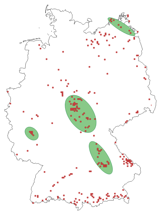
Darstellungsdienst seltene Baumart Eibe in Deutschland
Der Darstellungsdienst zeigt auf Basis von Rasterzellen (5 km x 5 km) das Vorkommen, die Baumanzahl, den Zustand der Naturverjüngung, die Vitalität, die Erhaltungsfähigkeit der Vorkommen sowie die daraus resultierenden Genzentren der Eibe. Die Ergebnisse stammen aus einer Untersuchung zur Erfassung seltener Waldbaumarten in Deutschland, die im Auftrag des Bundesministeriums für Ernährung und Landwirtschaft (BMEL) durchgeführt wurde. Der Zugriff auf die Sachinformationen (GetFeatureInfo) ist beschränkt.
Mit der Veröffentlichung soll die Erhaltung und nachhaltige Nutzung der Baumart Eibe in Deutschland unterstützt werden.
|
|
Citation proposal
. Darstellungsdienst seltene Baumart Eibe in Deutschland. https://gdk.gdi-de.org/geonetwork/srv/api/records/a3018d04-5d64-412e-88f7-fc315fb8e0c0 |
INSPIRE
Identification
- File identifier
- a3018d04-5d64-412e-88f7-fc315fb8e0c0 XML
- Hierarchy level
- Service
Online resource
- Protocol
- OGC:WMS-1.3.0-http-get-capabilities
- Protocol
- OGC:WMS-http-get-map
- Protocol
- OGC:WMS-http-get-map
- Protocol
- OGC:WMS-http-get-map
- Protocol
- OGC:WMS-http-get-map
- Protocol
- OGC:WMS-http-get-map
- Protocol
- OGC:WMS-http-get-map
Resource identifier
Encoding
- Format
- PNG
- Version
- unknown
Projection
Classification of data and services
Classification of data and services
- Service Type
- view
- Coupling Type
- Tight
Coupled resource
Coupled resource
Classification of data and services
- Service Type
- view
- Coupling Type
- Tight
Coupled resource
Coupled resource
Keywords
Other keywords
- Keywords ( Theme )
-
- humanInteractionService
- WMS
- infoMapAccessService
- Waldwirtschaft
- Genetische Ressourcen
- Ressourcenwirtschaft
- Baum
- Genetische Vielfalt
- Forstwirtschaft
- Eibe
- Bundesanstalt für Landwirtschaft und Ernährung (BLE)
Geographic coverage
))
Temporal reference
Temporal extent
Temporal extent
- Date ( Creation )
- 2014-08-16
Quality and validity
Conformity
Conformity
Conformity
Conformity
Conformity
Conformity
- Explanation
- See the referenced specification
- Explanation
- See the referenced specification
Restrictions on access and use
Restrictions on access and use
- Access constraints
-
Dieser Datensatz kann gemäß der Verordnung zur Festlegung der Nutzungsbestimmungen für die Bereitstellung von Geodaten des Bundes (GeoNutzV) vom 19. März 2013 (BGBl. I S. 547) (https://sg.geodatenzentrum.de/web_public/gdz/lizenz/geonutzv.pdf) genutzt werden. Der Quellenvermerk ist zu beachten.
Als Rechteinhaberin und Bereitstellerin ist die Bundesanstalt für Landwirtschaft und Ernährung (BLE) und das Jahr des Datenbezugs wie folgt anzugeben: © BLE (<Jahr des Datenbezugs>), Datenquellen: https://gdi.bmel.de/fileadmin/SITE_MASTER/content/Webdienste_Datenquellen_BLE.pdf
Responsible organization (s)
Contact for the resource
- Organisation name
- Bundesanstalt für Landwirtschaft und Ernährung (BLE)
- IBV@ble.de
Responsible organization (s)
Contact for the resource
- Organisation name
- Bundesanstalt für Landwirtschaft und Ernährung (BLE)
- IBV@ble.de
Metadata information
Contact for the metadata
- Organisation name
- Bundesanstalt für Landwirtschaft und Ernährung (BLE)
- Date stamp
- 2025-11-07T12:56:48.704Z
- Metadata language
- German
SDS
Conformance class 1: invocable
- Pass
- false
- Pass
- false
Access Point URL
Endpoint URL
Technical specification
- Date
- Explanation
- See the referenced specification
- Date
- Explanation
- See the referenced specification
Conformance class 2: interoperable
Coordinate reference system
Quality of Service
Access constraints
- Access constraints
- Other restrictions
Limitation
Use constraints
Limitation
- string
-
Dieser Datensatz kann gemäß der Verordnung zur Festlegung der Nutzungsbestimmungen für die Bereitstellung von Geodaten des Bundes (GeoNutzV) vom 19. März 2013 (BGBl. I S. 547) (https://sg.geodatenzentrum.de/web_public/gdz/lizenz/geonutzv.pdf) genutzt werden. Der Quellenvermerk ist zu beachten.
Als Rechteinhaberin und Bereitstellerin ist die Bundesanstalt für Landwirtschaft und Ernährung (BLE) und das Jahr des Datenbezugs wie folgt anzugeben: © BLE (<Jahr des Datenbezugs>), Datenquellen: https://gdi.bmel.de/fileadmin/SITE_MASTER/content/Webdienste_Datenquellen_BLE.pdf
Responsible custodian
Contact for the resource
Conformance class 3: harmonized
Contains Operations
- Operation Name
- GetCapabilities
- Distributed Computing Platforms
- Web services
- Connect Point
- GetCapabilities-Request, Format: XML
Contains Operations
- Operation Name
- GetMap-Request (Eibe_Genzentren)
- Distributed Computing Platforms
- Web services
- Connect Point
- Genzentren, GetMap-Request, Format: PNG
Contains Operations
- Operation Name
- GetLegendGraphic-Request (Eibe_Genzentren)
- Distributed Computing Platforms
- Web services
- Connect Point
- Genzentren, GetLegendGraphic-Request, Format: PNG
Contains Operations
- Operation Name
- GetMap-Request (Eibe_Erhaltungsfaehigkeit)
- Distributed Computing Platforms
- Web services
- Connect Point
- Erhaltungsfähigkeit, GetMap-Request, Format: PNG
Contains Operations
- Operation Name
- GetLegendGraphic-Request (Eibe_Erhaltungsfaehigkeit)
- Distributed Computing Platforms
- Web services
Contains Operations
- Operation Name
- GetMap-Request (Eibe_Vitalitaet)
- Distributed Computing Platforms
- Web services
- Connect Point
- Vitalität, GetMap-Request, Format: PNG
Contains Operations
- Operation Name
- GetLegendGraphic-Request (Eibe_Vitalitaet)
- Distributed Computing Platforms
- Web services
- Connect Point
- Vitalität, GetLegendGraphic-Request, Format: PNG
Contains Operations
- Operation Name
- GetMap-Request (Eibe_Naturverjuengung)
- Distributed Computing Platforms
- Web services
- Connect Point
- Naturverjüngung, GetMap-Request, Format: PNG
Contains Operations
- Operation Name
- GetLegendGraphic-Request (Eibe_Naturverjuengung)
- Distributed Computing Platforms
- Web services
- Connect Point
- Naturverjüngung, GetLegendGraphic-Request, Format: PNG
Contains Operations
- Operation Name
- GetMap-Request (Eibe_Baumanzahl)
- Distributed Computing Platforms
- Web services
Contains Operations
- Operation Name
- GetLegendGraphic-Request (Eibe_Baumanzahl)
- Distributed Computing Platforms
- Web services
- Connect Point
- Eibevorkommen, GetLegendGraphic-Request, Format: PNG
Contains Operations
- Operation Name
- GetMap-Request (Eibe_Vorkommen)
- Distributed Computing Platforms
- Web services
- Connect Point
- Eibevorkommen, GetMap-Request, Format: PNG
Contains Operations
- Operation Name
- GetLegendGraphic-Request (Eibe_Vorkommen)
- Distributed Computing Platforms
- Web services
- Connect Point
- Eibevorkommen, GetLegendGraphic-Request, Format: PNG
Overviews
Provided by
