 www.geodatenkatalog.de (S3L)
Forest Structure - Sentinel-1/2, GEDI - Germany, Yearly
|
|
Citation proposal
German Aerospace Center (DLR). Forest Structure - Sentinel-1/2, GEDI - Germany, Yearly. https://gdk.gdi-de.org/geonetwork/srv/api/records/a3c5b57f-8d87-42d2-a3b2-8f5a230964ae |
Simple
- Date ( Creation )
- 2023-11-16T12:48:00
- Edition
- Presentation form
- Digital map
- Purpose
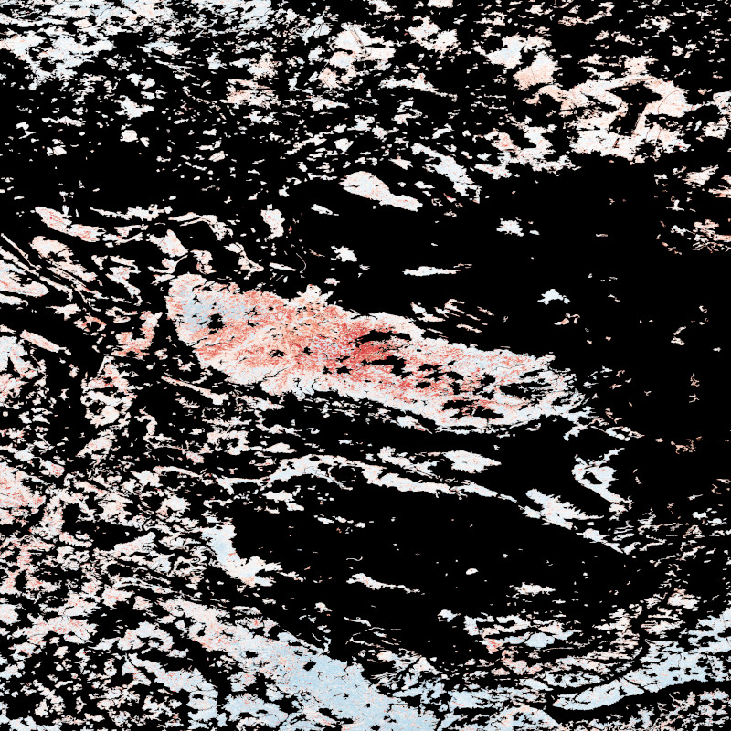
- This map shows the forest structure in Germany based on information on canopy height, total canopy cover and Above-ground biomass density (AGBD).
- Status
- Completed
Point of contact
- Maintenance and update frequency
- As needed
- GEMET - INSPIRE themes, version 1.0 ( Theme )
-
- Land cover
- Spatial scope ( Place )
- Keywords
-
- DLR
- EOC
- Forest
- Forest structure
- Drought
- Machine Learning Model
- Germany
- Yearly
- Sentinel-1
- Sentinel-2
- GEDI
- opendata
- Use limitation
- Nutzungseinschränkungen: Das DLR ist nicht haftbar für Schäden, die sich aus der Nutzung ergeben. / Use Limitations: DLR not liable for damage resulting from use.
- Access constraints
- Other restrictions
- Use constraints
- Other restrictions
- Other constraints
- Nutzungsbedingungen: Lizenz, https://creativecommons.org/licenses/by/4.0 / Terms of use: License, https://creativecommons.org/licenses/by/4.0
- Other constraints
-
{"id": "cc-by-4.0",
"name": "Creative Commons Namensnennung - 4.0 International (CC BY 4.0)",
"url": "http://dcat-ap.de/def/licenses/cc-by/4.0",
"quelle": "Copyright DLR (year of production)"}
- Spatial representation type
- Grid
- Denominator
- 20000
- Metadata language
- English
- Character set
- UTF8
- Topic category
-
- Imagery base maps earth cover
))
- Number of dimensions
- 2
- Dimension name
- Column
- Dimension size
- 102120
- Resolution
- 10 m
- Dimension name
- Row
- Dimension size
- 86697
- Resolution
- 10 m
- Cell geometry
- Area
- Transformation parameter availability
- false
- Distribution format
-
- GeoTIFF ()
- OnLine resource
-
EOC Geoservice Dataset
EOC Geoservice Dataset
- OnLine resource
-
FOREST_STRUCTURE_DE_AGBD_P1Y
Forest Structure Germany - Above-Ground Biomass Density - Yearly
- OnLine resource
-
FOREST_STRUCTURE_DE_COVER_P1Y
Forest Structure Germany - Canopy Cover - Yearly
- OnLine resource
-
FOREST_STRUCTURE_DE_RH95_P1Y
Forest Structure Germany - Canopy Height - Yearly
- OnLine resource
-
EOC Download Service
EOC Download Service (Forest Structure Germany)
- Hierarchy level
- Dataset
Domain consistency
- Measure identification
- INSPIRE / Conformity_001
Conformance result
- Date ( Publication )
- 2010-12-08
- Explanation
- See the referenced specification.
- Pass
- true
- Statement
- Sentinel-1 and Sentinel-2 (less than 60 % cloud coverage) data for the months April to September available through the Google Earth Engine (GEE) were used. In addition, GEDI L2A, L2B, and L4A data from 2019 to 2022 for the months June to August were used. At the date of data processing GEDI data for 2022 was only available for the month June.
- Description
-
Processing: The Sentinel-1 GRD dataset available from GEE was processed ARD using the methodology explained in Mullissa et al. 2021 (https://doi.org/10.3390/rs13101954). Sentinel-2 L2A surface reflectance was processed using sen2cor in GEE.
Quality assurance: With regard to the modelling accuracy, a statistical comparison to independent samples of GEDI was calculated. According to the mean statistics for all years, the canopy height models reach a coefficient of variation (R2) of 64.6 % and a Mean-Absolute-Error (MAE) of 4.4 m. The mean accuracy of total canopy cover models for all years amounts to 67.0 % (R2) and 12.5 % (MAE). The Above-ground biomass density (AGBD) models have a accuracy of 58.8 % in R2 and 41.0 Mg/ha in MAE.
gmd:MD_Metadata
- File identifier
- a3c5b57f-8d87-42d2-a3b2-8f5a230964ae XML
- Metadata language
- English
- Character set
- UTF8
- Hierarchy level
- Dataset
- Hierarchy level name
- Dataset
- Date stamp
- 2025-02-14T13:08:04
- Metadata standard name
- ISO 19115-1:2014/19139
- Metadata standard version
- 2003/Cor.1:2006
Point of contact
Overviews
Provided by
