 www.geodatenkatalog.de (S3L)
BRG NRW WMS - Bohrungen in NRW - Darstellungsdienst
Dieser WMS stellt den Datensatz „Bohrungen in NRW“ und damit die Lage der in der Datenbank „Aufschlüsse und Bohrungen in Nordrhein-Westfalen“ [DABO] erfassten sowie der über das Portal „Bohranzeige NRW" angezeigten Bohrungen dar. Aus den Stammdaten der Schichtenverzeichnisse werden Angaben gemacht zu Lage, Nummer, Länge und Zweck der Bohrung sowie zur geologischen Einstufung der tiefsten erbohrten Schicht. Es wird zwischen vier Kategorien unterschieden: Grün = Schichtdaten freigegeben; Rot = Schichtdaten (noch) nicht freigegeben; Orange = Schichtdaten noch nicht verfügbar; Blau = angezeigt, noch nicht gebohrt.
|
|
Citation proposal
(2023) . BRG NRW WMS - Bohrungen in NRW - Darstellungsdienst. https://gdk.gdi-de.org/geonetwork/srv/api/records/a46d313b-1dfc-435f-924f-fae9bef2df8f |
INSPIRE
Identification
- File identifier
- a46d313b-1dfc-435f-924f-fae9bef2df8f XML
- Hierarchy level
- service Service
Online resource
Resource identifier
Encoding
Projection
Classification of data and services
Classification of data and services
- Service Type
- WMS
- Coupling Type
- Tight
Coupled resource
Coupled resource
Classification of data and services
- Service Type
- WMS
- Coupling Type
- Tight
Coupled resource
Coupled resource
Keywords
- UMTHES Thesaurus ( Theme )
-
- Geologie
- Gestein
- Bohrung
- Lockergestein
- Festgestein
- Rohstoff
- Bauland
- Lagerstätte
- Stratigraphie
- Brunnen
- OGDD-Kategorien
-
- geo
Other keywords
- Keywords
-
- Bohrprofil
- GeolDG
- Nachweisdaten
- opendata
- Keywords
-
- infoMapAccessService
Geographic coverage
N
S
E
W
))
Temporal reference
Temporal extent
Temporal extent
- Date ( Publication )
- 2023-05-11
Quality and validity
- Lineage
- Datensatz BRG NRW
Conformity
Conformity
Conformity
Conformity
Conformity
Conformity
Restrictions on access and use
Restrictions on access and use
- Access constraints
- Nutzungsbedingungen: {"id":"dl-by-de/2.0", "name": "Datenlizenz Deutschland Namensnennung 2.0", "url": "https://www.govdata.de/dl-de/by-2-0", "Bohrungen in NRW (WMS) @Geologischer Dienst NRW, Abrufdatum"}
Responsible organization (s)
Contact for the resource
- Organisation name
- Geologischer Dienst NRW
- geodaten@gd.nrw.de
Responsible organization (s)
Contact for the resource
- Organisation name
- Geologischer Dienst NRW
- geodaten@gd.nrw.de
Metadata information
Contact for the metadata
- Organisation name
- Geologischer Dienst NRW
- metadaten@gd.nrw.de
- Date stamp
- 2024-04-08
- Metadata language
- ger German
SDS
Conformance class 1: invocable
Access Point URL
Endpoint URL
Technical specification
Conformance class 2: interoperable
Coordinate reference system
Quality of Service
Access constraints
- Access constraints
- Other restrictions
Limitation
Use constraints
Limitation
- string
- Nutzungsbedingungen: {"id":"dl-by-de/2.0", "name": "Datenlizenz Deutschland Namensnennung 2.0", "url": "https://www.govdata.de/dl-de/by-2-0", "Bohrungen in NRW (WMS) @Geologischer Dienst NRW, Abrufdatum"}
Responsible custodian
Contact for the resource
Conformance class 3: harmonized
Contains Operations
- Operation Name
- GetCapabilities
- Distributed Computing Platforms
- Web services
- Invocation Name
- GetCapabilities
Parameter
- Name
- REQUEST=GetCapabilities
- Name
- Optionality
- 0
- Repeatability
- false
- Name
Parameter
- Name
- UPDATESEQUENCE=number
- Name
- Optionality
- 1
- Repeatability
- false
- Name
Parameter
- Name
- VERSION=version
- Name
- Optionality
- 1
- Repeatability
- false
- Name
Parameter
- Name
- SERVICE=WMS
- Name
- Optionality
- 0
- Repeatability
- false
- Name
Contains Operations
- Operation Name
- GetMap
- Distributed Computing Platforms
- Web services
- Connect Point
- https://www.wms.nrw.de/gd/brgnrw?
Overviews
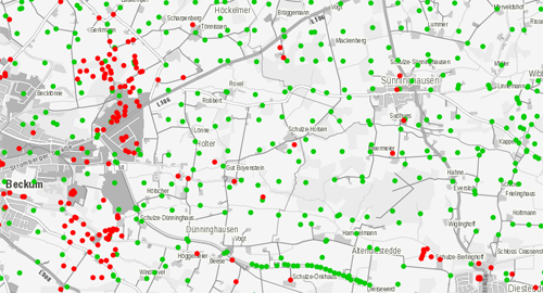
Vorschaubild BRGNRW WMS
Provided by

Views
a46d313b-1dfc-435f-924f-fae9bef2df8f
Access to the portal
Read here the full details and access to the data.
Associated resources
Not available