 www.geodatenkatalog.de (S1L)
Schwerefestpunktfeld - Saarland
Die SFP sind Festpunkte, die in der Örtlichkeit dauerhaft vermarkt und deren Schwerewerte, Koordinaten und Höhen bestimmt sind. Sie bilden in ihrer Summe das Schwerefestpunktfeld. Der Nachweis der SFP umfasst: - Punktdaten in Form von Schwere-, Höhenwerten und Lagekoordinaten - Punktbeschreibungen (Einmessungsskizzen) - Punktübersichten auf der Grundlage der Topographischen Karte 1:25000 (TK 25) mit Punktsignaturen und -nummern - Punktübersichten: Top. Karte 1: 25 000 mit eingezeichneten Punktsignaturen und -nummern
|
|
Citation proposal
. Schwerefestpunktfeld - Saarland. https://gdk.gdi-de.org/geonetwork/srv/api/records/a4c2c4f0-8028-4817-a376-f8bde585abf0 |
INSPIRE
Identification
- File identifier
- a4c2c4f0-8028-4817-a376-f8bde585abf0 XML
- Hierarchy level
- Dataset
Online resource
Resource identifier
- code
- Metadata language
- German
- Spatial representation type
- Text, table
Encoding
Projection
Classification of data and services
- Topic category
-
- Geoscientific information
- Elevation
- Imagery base maps earth cover
Classification of data and services
Coupled resource
Coupled resource
Classification of data and services
Coupled resource
Coupled resource
Keywords
Other keywords
- Keywords ( Theme )
-
- Festpunkte Höhenfestpunkt Lagefestpunkt Schwerefestpunkt
- Keywords ( Place )
-
- Saarland
- Keywords
-
- AdVMIS
- geoportal
Geographic coverage
N
S
E
W
))
Temporal reference
Temporal extent
Temporal extent
- Date ( Creation )
- 2013-11-07
- Date ( Revision )
- 2022-06-22
Quality and validity
- Lineage
- Örtliche Gravimetermessungen
Conformity
Conformity
Conformity
Conformity
Conformity
Conformity
Restrictions on access and use
Restrictions on access and use
Responsible organization (s)
Contact for the resource
- Organisation name
- Landesamt für Vermessung, Geoinformation und Landentwicklung
Responsible organization (s)
Contact for the resource
- Organisation name
- Landesamt für Vermessung, Geoinformation und Landentwicklung
Metadata information
Contact for the metadata
- Organisation name
- Landesamt für Vermessung, Geoinformation und Landentwicklung
- Date stamp
- 2022-07-28
- Metadata language
- German
- Character set
- UTF8
SDS
Conformance class 1: invocable
Access Point URL
Endpoint URL
Technical specification
Conformance class 2: interoperable
Coordinate reference system
Quality of Service
Access constraints
Limitation
Use constraints
Limitation
Responsible custodian
Contact for the resource
Conformance class 3: harmonized
Overviews
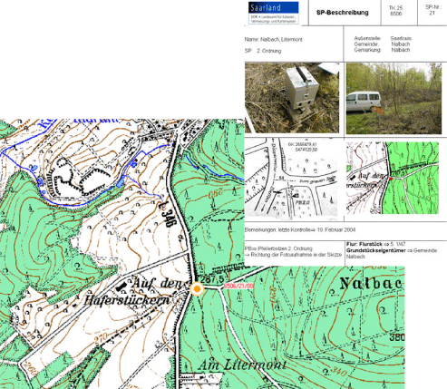
Ausschnitt Übersicht und Bescheibung
Provided by

Views
a4c2c4f0-8028-4817-a376-f8bde585abf0
Access to the portal
Read here the full details and access to the data.
Associated resources
Not available