 www.geodatenkatalog.de (S2F)
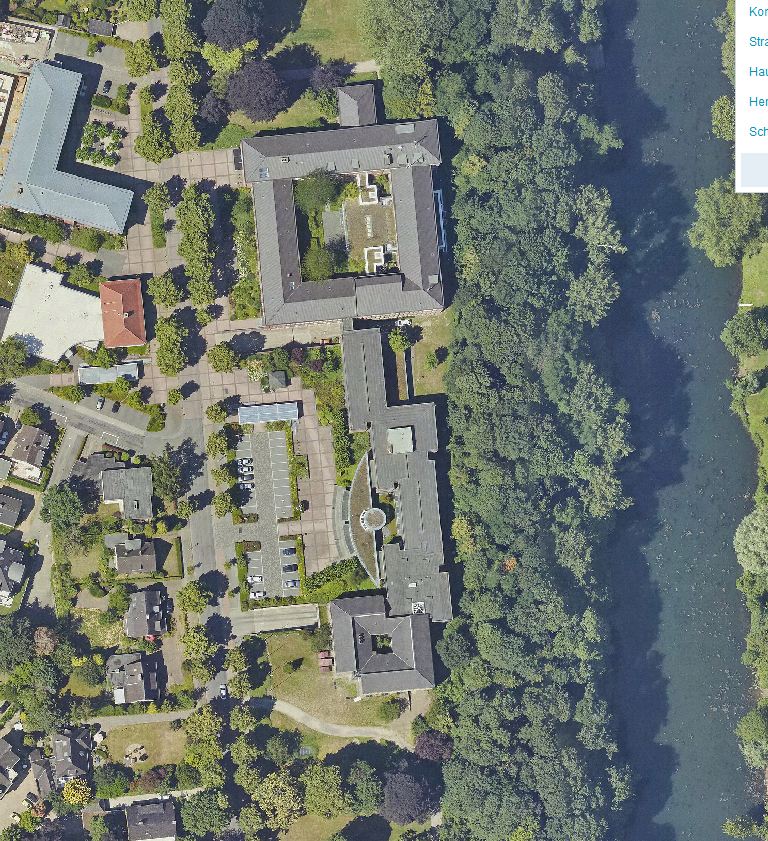
Kommunale Luftbilder 2019 Kreis Kleve - DOP8 - Nord
Der Datensatz besteht aus hochaufgelösten Luftbildern, die aus kreiseigenen Befliegungsaufträgen stammen und als klassische Digitale Orthophotos (DOP) bereitgestellt. Diese Rasterdaten sind verzerrungsfreie, georeferenzierte, hochauflösende und maßstabsgetreue photographische Abbildungen der Erdoberfläche. Die Daten liegen flächendeckend für das ganze Kreisgebiet mit unterschiedlicher Aktualität vor. Seit 2016 wird jährlich 1/3 des Kreisgebietes beflogen. Die Luftbilder des Jahres 2019 liegen für die Kommunen Bedburg-Hau, Emmerich, Kalkar, Kleve und Rees (Nord) vor. Sie haben eine Bodenauflösung von 8 cm und sind damit datenschutzrechtlich schützenswert.
|
|
Citation proposal
(2025) . Kommunale Luftbilder 2019 Kreis Kleve - DOP8 - Nord. Kreis Kleve - Der Landrat https://gdk.gdi-de.org/geonetwork/srv/api/records/a550e5ee-637d-4bd1-99c9-f0c3c92f704c |
INSPIRE
Identification
- File identifier
- a550e5ee-637d-4bd1-99c9-f0c3c92f704c XML
- Hierarchy level
- dataset Dataset
Online resource
Resource identifier
- Metadata language
- German
Encoding
- Format
- ECW
Projection
Classification of data and services
- Topic category
-
- Geoscientific information
- Planning cadastre
- Imagery base maps earth cover
Classification of data and services
Coupled resource
Coupled resource
Classification of data and services
Coupled resource
Coupled resource
Keywords
- GEMET - Concepts, version 3.1 ( Theme )
Other keywords
- Keywords
-
- DOP
- Bodenauflösung
- Luftbild
- Luftbilder
- kommunal
- Orthofoto
- True DOP
- hochaufgelöst
- Kreis Kleve
- NRW
- NW
- 05154
- Bedburg-Hau
- Emmerich
- Kalkar
- Kleve
- Rees
- 05154036
- 05154004
- 05154008
- 05154024
- 05154044
- 2019
Geographic coverage
N
S
E
W
))
Temporal reference
Temporal extent
Temporal extent
- Date ( Publication )
- 2025-01-13T00:00:00.000+01:00
Quality and validity
- Lineage
- Katastermodernisierung/Aufbau/Fortführung der ABK
Conformity
Conformity
Conformity
Conformity
Conformity
Conformity
Restrictions on access and use
- Access constraints
- Nutzung der Daten nur nach Rücksprache mit dem Dateneigentümer
Restrictions on access and use
Responsible organization (s)
Contact for the resource
- Organisation name
- Kreis Kleve - Der Landrat
- info@kreis-kleve.de
- Organisation name
- Kreis Kleve - Abt. Kataster- und Vermessung - Produktbereich GeoInformation (GIS)
Responsible organization (s)
Contact for the resource
- Organisation name
- Kreis Kleve - Der Landrat
- info@kreis-kleve.de
- Organisation name
- Kreis Kleve - Abt. Kataster- und Vermessung - Produktbereich GeoInformation (GIS)
Metadata information
Contact for the metadata
- Organisation name
- Kreis Kleve - Abt. Kataster- und Vermessung - Produktbereich GeoInformation (GIS)
- Date stamp
- 2025-01-15
- Metadata language
- German
SDS
Conformance class 1: invocable
Access Point URL
Endpoint URL
Technical specification
Conformance class 2: interoperable
Coordinate reference system
Quality of Service
Access constraints
Limitation
Use constraints
Limitation
Responsible custodian
Contact for the resource
Conformance class 3: harmonized
Overviews
Kommunale Luftbilder 2019 Kreis Kleve - Nord
Provided by

Views
a550e5ee-637d-4bd1-99c9-f0c3c92f704c
Access to the portal
Read here the full details and access to the data.
Associated resources
Not available