 www.geodatenkatalog.de (S1L)
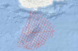
Processed seismic data of Cruise MSM14/2 2010
The initial study area of the cruise MSM14/2 GeoNORM (Geophysik im noerdlichen Roten Meer) was the northern Red Sea. However, because of not given research permissions from Egypt and Saudi Arabia, the study area had to be changed to the alternative study area Eratosthenes Seamount (ESM), south of Cyprus. The ESM is supposed to represent a continental fragment of the former African-Arabian Plate that is entering the subduction zone south of Cyprus i.e. the subduction turns into collision in the area of the ESM. This changed the entire tectonic setting in the Eastern Mediterranean. Therefore, the tectonic evolution of the area is rather complex with phases of extension, subduction, compression, salt tectonics and gravitational processes and not comprehensively understood. Because of the isolation of the ESM as a continental fragment this region is an ideal spot to investigate the transition from regular subduction to continental collision and its associated tectonic processes i.e. faults were activated or reactivated, transform motion has to be compensated, the overriding plate has been elevated. This impacts the ongoing geological and tectonic processes in this region but also influences the social and economic life in the Eastern Mediterranean as earthquakes and submarine landslides are possible geohazards and the entering of the ESM to the subduction trench alters the thermal history of the adjacent sedimentary basins significantly what should have an influence on the maturity processes within the source rock sediments and new faults open new migration paths for hydrocarbon fluids or gases.
|
|
Citation proposal
. Processed seismic data of Cruise MSM14/2 2010. https://gdk.gdi-de.org/geonetwork/srv/api/records/a65f2630-48dd-4c51-908b-4f14ca4b89c4 |
INSPIRE
Identification
- File identifier
- a65f2630-48dd-4c51-908b-4f14ca4b89c4 XML
- Hierarchy level
- Dataset
Online resource
Resource identifier
- code
- a9665b1b-1110-e2bf-f1a3-bab04397faac
- Metadata language
- English
- Spatial representation type
- Vector
Encoding
- Format
- Shapefile
- Version
- n/a
Projection
Classification of data and services
- Topic category
-
- Geoscientific information
Classification of data and services
Coupled resource
Coupled resource
Classification of data and services
Coupled resource
Coupled resource
Keywords
- GEMET - INSPIRE themes, version 1.0 ( Theme )
-
- Geologie
- geology
- GEMET - Concepts, version 2.4 ( Theme )
-
- geophysics
- Geophysik
- raw material
- Rohstoff
Other keywords
- Keywords ( Theme )
-
- Marine geology
- Meeresgeologie
- Seismics
- Seismik
- Two-dimensional seismic reflection
- zweidimensionale Reflektionsseismik
- Keywords ( Place )
-
- Zypern
- Cyprus
- Eratosthenes Seamount
- östliches Mittelmeer
- Eastern Mediterranean Sea
Geographic coverage
N
S
E
W
))
Temporal reference
Temporal extent
Temporal extent
- Date ( Creation )
- 2010-02-25
Quality and validity
- Lineage
- During the period from the 18th January to the 25th February 2010 BGR acquired seismic lines south of Cyprus in the Eastern Basin of the Mediterranean Sea. The lines BGR10-101a, BGR10-104a, BGR10-112a, BGR10-118a, BGR10-119, BGR10-122v, BGR10-131, BGR10-131a, BGR10-132, BGR10-133, BGR10-134, BGR10-135, BGR10-136, BGR10-137, BGR10-138 and BGR10-138a consist of raw data, the line BGR10-102 consist of stacked data and the lines BGR10-101, BGR10-103, BGR10-104, BGR10-105, BGR10-106, BGR10-107, BGR10-108, BGR10-109, BGR10-110, BGR10-111, BGR10-112, BGR10-113, BGR10-114, BGR10-115, BGR10-116, BGR10-117, BGR10-118,BGR10-119-2, BGR10-120-2, BGR10-121-2, BGR10-122-2, BGR10-123, BGR10-124, BGR10-125, BGR10-126, BGR10-127, BGR10-128, BGR10-129 and BGR10-130 are migrated data.
Conformity
Conformity
Conformity
Conformity
Conformity
Conformity
- Explanation
- siehe dazu die angegebene Durchführungsbestimmung
Restrictions on access and use
- Access constraints
- Allgemeine Geschäftsbedingungen, siehe http://www.bgr.bund.de/AGB - General terms and conditions, see http://www.bgr.bund.de/AGB_en. Die bereitgestellten Informationen sind bei Weiterverwendung wie folgt zu zitieren: Datenquelle: MSM14/2 2010, (c) BGR, Hannover, 2018
Restrictions on access and use
Responsible organization (s)
Contact for the resource
- Organisation name
- Federal Institute for Geosciences and Natural Resources
- Marine_Seismik@bgr.de
Responsible organization (s)
Contact for the resource
- Organisation name
- Federal Institute for Geosciences and Natural Resources
- Marine_Seismik@bgr.de
Metadata information
Contact for the metadata
- Organisation name
- Bundesanstalt für Geowissenschaften und Rohstoffe (BGR)
- Date stamp
- 2023-11-14
- Metadata language
- English
- Character set
- UTF8
SDS
Conformance class 1: invocable
Access Point URL
Endpoint URL
Technical specification
Conformance class 2: interoperable
Coordinate reference system
Quality of Service
Access constraints
Limitation
Use constraints
Limitation
Responsible custodian
Contact for the resource
Conformance class 3: harmonized
Overviews
Provided by

Views
a65f2630-48dd-4c51-908b-4f14ca4b89c4
Access to the portal
Read here the full details and access to the data.
Associated resources
Not available