 www.geodatenkatalog.de (S3L)
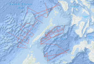
Processed seismic data of Cruise SO23 1982
In the framework of the IDOE-SEATAR (International Decade of Ocean Exploration - Studies of East Asia Tectonics and Resources) Program, the Federal Institute for Geosciences and Natural Resources carried out a geophysical survey in the Sulu Sea during the period from March 11, 1982 to April 15, 1982 using the German research vessel R/V SONNE. The SONNE cruise no. SO-23 continued SEATAR-related studies of BGR which have been carried out during the Southeast Asian Cruise of the VALDIVIA (VA-16) in 1977. During SONNE cruise no. SO-23, multi-channel reflection measurements were carried out in parallel with magnetic, gravimetric, and sea-beam measurements on 21 lines with a total length of 3,300 km in the Sulu Sea. In the NW Sulu Basin, situated between the shelf of East Palawan in the north and the volcanic Cagayan Ridge in the south, a 50 - 100 km wide graben-like basin exists which is filled with thick Neogene and pre-Middle Miocene sediments. The basin trends east-northeast. At longitude 119°E it bends to a north-south direction. The dominating structural element within the sedimentary graben-like basin is a diapiric-chaotic zone about 25 km wide, which was only detectable west of longitude 120°E. The base of the elongated diapiric-chaotic zone, which might represent a tectonically mobilized equivalent of the Crocker Formation (Middle Miocene - Lower Oligocene) is difficult to define in the seismic monitor records. The configuration and the internal structural style of individual structures of the diapiric-chaotic zone, which can be followed over length of about 150 km, seem to resemble those of the oil-bearing province offshore western Sabah. In the eastern part of the NW-Sulu Basin east of longitude 119°E, several north-trending anticlines of presumably Middle Miocene age and locally volcanic intrusions of presumably Plio-Pleistocene age have been observed. During the second leg of the cruise SO-23 in the southeastern part of the South China Sea (April 16, 1982, to May 9, 1982) multi-channel seismic reflection measurements were carried out in parallel with magnetic, gravimetric, and sea-beam measurements on 19 lines with a total length of 3,570 km in the southeastern part of the South China Sea, including the area of the Dangerous Grounds. In addition, 2,280 km of profile was surveyed with only magnetics, gravity, and sea-beam measurements. A complex structural style was observed in the investigated part of the Dangerous Grounds, South China Sea, which is believed to be part of a microcontinental block which rifted from the continental margin of Asia in the Early Paleogene/Late Mesozoic time. There are prospective depocenters and structures trending NE-SW, E-W, and N-S in the southwestern part, i.e. the area west of longitude 117.5°E (units 2, 3, 4). Unit 4 contains a series of half-grabens with thick sedimentary infill. An imbricated melange of pre-Middle Miocene age seems to exist only off southern Palawan. The dominating structural trend in the area northeast of Reed Bank is NW-SE. Oceanic crust characterized by NW-trending magnetic lineations (anomalies 8 to 12 ?) was observed north of latitude 12°N and between longitude 118°E and the Manila Trench.
|
|
Citation proposal
. Processed seismic data of Cruise SO23 1982. https://gdk.gdi-de.org/geonetwork/srv/api/records/a6d0adad-9b94-4dcf-9fcd-df2aee2b1408 |
INSPIRE
Identification
- File identifier
- a6d0adad-9b94-4dcf-9fcd-df2aee2b1408 XML
- Hierarchy level
- Dataset
Online resource
Resource identifier
- code
- a27585b9-ee68-46d3-c889-349a9a26f535
- Metadata language
- English
- Spatial representation type
- Vector
Encoding
- Format
- Shapefile
- Version
- n/a
Projection
Classification of data and services
- Topic category
-
- Geoscientific information
Classification of data and services
Coupled resource
Coupled resource
Classification of data and services
Coupled resource
Coupled resource
Keywords
- GEMET - INSPIRE themes, version 1.0 ( Theme )
-
- Geologie
- geology
- GEMET - Concepts, version 2.4 ( Theme )
-
- geophysics
- Geophysik
- raw material
- Rohstoff
Other keywords
- Keywords ( Theme )
-
- Marine geology
- Meeresgeologie
- Seismics
- Seismik
- Two-dimensional seismic reflection
- zweidimensionale Reflektionsseismik
- Keywords ( Place )
-
- South China Sea
- Südchinesisches Meer
- Sulu Sea
- Sulu-See
- Palawan
Geographic coverage
N
S
E
W
))
Temporal reference
Temporal extent
Temporal extent
- Date ( Creation )
- 1982-05-09
Quality and validity
- Lineage
- In the period from 11th March to 15th April 1982 and from 16th April to 9th May 1982 on SONNE cruise SO-23 BGR acquired seismic lines in the Sulu Sea and in the South China Sea (Dangerous Grounds). The lines SO23-02A, SO23-03, SO23-04, SO23-08, SO23-08A, SO23-09, SO23-11, SO23-12, SO23-13, SO23-14, SO23-14A, SO23-16, SO23-20, SO23-21 and SO23-29A consist of raw data. The lines SO23-22, SO23-22A, SO23-23, SO23-24, SO23-25, SO23-26, SO23-27, SO23-28, SO23-29, SO23-30, SO23-31, SO23-32, SO23-33, SO23-34, SO23-35, SO23-35A, SO23-36, SO23-37, SO23-39, SO23-39A and SO23-40 are stacked data. The lines SO23-01, SO23-01A, SO23-02, SO23-05, SO23-06, SO23-07, SO23-10, SO23-17, SO23-18, SO23-19 and SO23-38 are migrated data.
Conformity
Conformity
Conformity
Conformity
Conformity
Conformity
- Explanation
- siehe dazu die angegebene Durchführungsbestimmung
Restrictions on access and use
- Access constraints
- Allgemeine Geschäftsbedingungen, siehe http://www.bgr.bund.de/AGB - General terms and conditions, see http://www.bgr.bund.de/AGB_en. Die bereitgestellten Informationen sind bei Weiterverwendung wie folgt zu zitieren: Datenquelle: SO23 1982, (c) BGR, Hannover, 2019
Restrictions on access and use
Responsible organization (s)
Contact for the resource
- Organisation name
- Federal Institute for Geosciences and Natural Resources
- Marine_Seismik@bgr.de
Responsible organization (s)
Contact for the resource
- Organisation name
- Federal Institute for Geosciences and Natural Resources
- Marine_Seismik@bgr.de
Metadata information
Contact for the metadata
- Organisation name
- Bundesanstalt für Geowissenschaften und Rohstoffe (BGR)
- Date stamp
- 2023-11-16
- Metadata language
- English
- Character set
- UTF8
SDS
Conformance class 1: invocable
Access Point URL
Endpoint URL
Technical specification
Conformance class 2: interoperable
Coordinate reference system
Quality of Service
Access constraints
Limitation
Use constraints
Limitation
Responsible custodian
Contact for the resource
Conformance class 3: harmonized
Overviews
Provided by

Views
a6d0adad-9b94-4dcf-9fcd-df2aee2b1408
Access to the portal
Read here the full details and access to the data.
Associated resources
Not available