 www.geodatenkatalog.de (S1L)
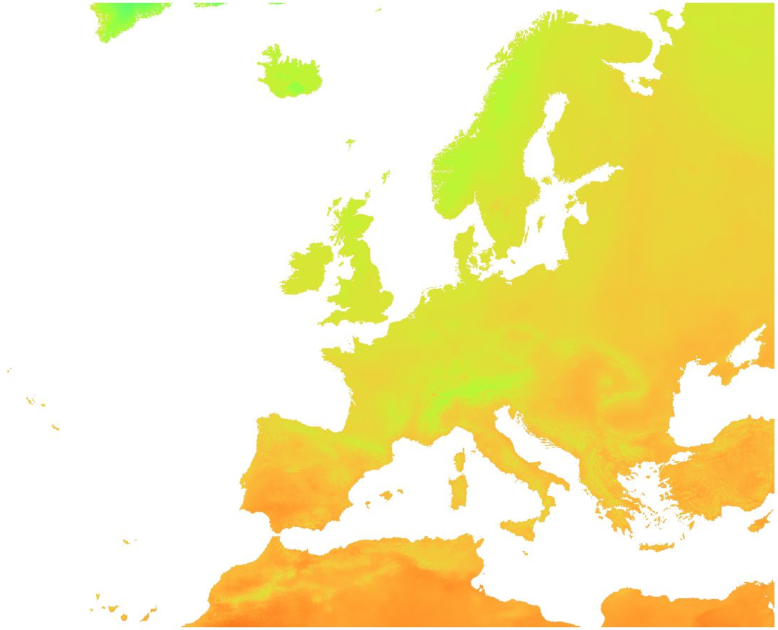
ERA5-Land daily: Surface temperature (2000 - 2020)
Overview:
ERA5-Land is a reanalysis dataset providing a consistent view of the evolution of land variables over several decades at an enhanced resolution compared to ERA5. ERA5-Land has been produced by replaying the land component of the ECMWF ERA5 climate reanalysis. Reanalysis combines model data with observations from across the world into a globally complete and consistent dataset using the laws of physics. Reanalysis produces data that goes several decades back in time, providing an accurate description of the climate of the past.
Surface temperature:
Temperature of the surface of the Earth. The skin temperature is the theoretical temperature that is required to satisfy the surface energy balance. It represents the temperature of the uppermost surface layer, which has no heat capacity and so can respond instantaneously to changes in surface fluxes.
The original ERA5-Land dataset (period: 2000 - 2020) has been reprocessed to:
- aggregate ERA5-Land hourly data to daily data (minimum, mean, maximum)
- while increasing the spatial resolution from the native ERA5-Land resolution of 0.1 degree (~ 9 km) to 30 arc-sec (~ 1 km) by image fusion with CHELSA data (V1.2) (https://chelsa-climate.org/).
For each day we used the corresponding monthly long-term average of CHELSA. The aim was to use the fine spatial detail of CHELSA and at the same time preserve the general regional pattern and fine temporal detail of ERA5-Land. The steps included aggregation and enhancement, specifically:
1. spatially aggregate CHELSA to the resolution of ERA5-Land
2. calculate difference of ERA5-Land - aggregated CHELSA
3. interpolate differences with a Gaussian filter to 30 arc seconds
4. add the interpolated differences to CHELSA
Data available is the daily average, minimum and maximum of surface temperature.
Software used:
GDAL 3.2.2 and GRASS GIS 8.0.0 (r.resamp.stats -w; r.relief)
Original ERA5-Land dataset license:
https://cds.climate.copernicus.eu/api/v2/terms/static/licence-to-use-copernicus-products.pdf
CHELSA climatologies (V1.2):
Data used: Karger D.N., Conrad, O., Böhner, J., Kawohl, T., Kreft, H., Soria-Auza, R.W., Zimmermann, N.E, Linder, H.P., Kessler, M. (2018): Data from: Climatologies at high resolution for the earth's land surface areas. Dryad digital repository. http://dx.doi.org/doi:10.5061/dryad.kd1d4
Original peer-reviewed publication: Karger, D.N., Conrad, O., Böhner, J., Kawohl, T., Kreft, H., Soria-Auza, R.W., Zimmermann, N.E., Linder, P., Kessler, M. (2017): Climatologies at high resolution for the Earth land surface areas. Scientific Data. 4 170122. https://doi.org/10.1038/sdata.2017.122
|
|
Citation proposal
(2021) . ERA5-Land daily: Surface temperature (2000 - 2020). https://gdk.gdi-de.org/geonetwork/srv/api/records/a72f738b-6704-4d00-98d7-a83f61346560 |
INSPIRE
Identification
- File identifier
- a72f738b-6704-4d00-98d7-a83f61346560 XML
- Hierarchy level
- Dataset
Online resource
- Protocol
- WWW:DOWNLOAD-1.0-http--download
Resource identifier
- Metadata language
- English
- Spatial representation type
- Grid
Encoding
- Format
- GeoTIFF
- Version
Projection
- code
- WGS 84 (EPSG:4326)
Classification of data and services
- Topic category
-
- Environment
- Geoscientific information
- Health
- Climatology, meteorology, atmosphere
Classification of data and services
Coupled resource
Coupled resource
Classification of data and services
Coupled resource
Coupled resource
Keywords
- GEMET - INSPIRE themes, version 1.0 ( Theme )
-
- Meteorological geographical features
- Continents, countries, sea regions of the world. ( Place )
-
- Europe
Other keywords
- Keywords ( Theme )
-
- surface temperature
- Keywords ( Theme )
-
- MOOD-H2020
- Tularaemia
- Lyme
- TBE
- WNV
- USUTU
- Mosquito borne Flaviviruses
Geographic coverage
))
Temporal reference
Temporal extent
Temporal extent
- Date ( Publication )
- 2021-10-26
Quality and validity
- Lineage
- Dataset has been processed from original Copernicus Climate Data Store (ERA5-Land) data sources. As auxiliary data CHELSA climate data has been used.
- Distance
- 1 km
Conformity
Conformity
Conformity
Conformity
Conformity
Conformity
- Explanation
- See specified reference
Restrictions on access and use
- Access constraints
- Licence to Use Copernicus Products (Version 1.2, Nov. 2019): "All users of Copernicus Products must provide clear and visible attribution to the Copernicus programme. The Licensee will communicate to the public the source of the Copernicus Products by crediting the Copernicus Climate Change and Atmosphere Monitoring Services" (full licence available here: https://cds.climate.copernicus.eu/api/v2/terms/static/licence-to-use-copernicus-products.pdf
- Access constraints
- { "id": "other-open", "name": "Licence to Use Copernicus Products", "url": "https://ads.atmosphere.copernicus.eu/api/v2/terms/static/licence-to-use-copernicus-products.pdf", "quelle": "Source: Copernicus Programme" }
Restrictions on access and use
Responsible organization (s)
Contact for the resource
- Organisation name
- mundialis GmbH & Co. KG
- info@mundialis.de
Responsible organization (s)
Contact for the resource
- Organisation name
- mundialis GmbH & Co. KG
- info@mundialis.de
Metadata information
Contact for the metadata
- Organisation name
- mundialis GmbH & Co. KG
- info@mundialis.de
- Date stamp
- 2025-03-07T14:18:43
- Metadata language
- English
- Character set
- UTF8
SDS
Conformance class 1: invocable
Access Point URL
Endpoint URL
Technical specification
Conformance class 2: interoperable
Coordinate reference system
Quality of Service
Access constraints
Limitation
Use constraints
Limitation
Responsible custodian
Contact for the resource
Conformance class 3: harmonized
Overviews
Provided by
