 www.geodatenkatalog.de (S2L)
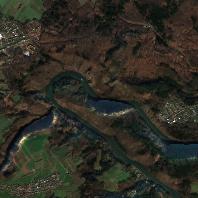
Sentinel2 - True Color Image
Sentinel-2 Echtfarbenbild (TrueColorImage), Kombination der Spektralkanäle B4 (rot), B3 (grün) und B2 (blau), räumliche Auflösung 10 m (2019)
|
|
Citation proposal
. Sentinel2 - True Color Image. https://gdk.gdi-de.org/geonetwork/srv/api/records/a7f439aa-a29e-445a-8eb5-4f42ba5b77b5 |
Simple
- Alternate title
- Sentinel2 -TCI
- Date ( Creation )
- 2015-08-02
- Date ( Revision )
- 2023-07-18
- Status
- On going
Point of contact
Landesamt für Vermessung, Geoinformation und Landentwicklung
-
Abt.2 Grundlagen, Geotopographie, Kartographie, Fernerkundung
Von der Heydt 22
Saarbrücken
Saarland
66115
Deutschland
- Keywords ( Theme )
-
- Sentinel2
- Keywords ( Place )
-
- Saarland
- mapbender.2.inspireDownload
-
- 0
- mapbender.2.inspireWholeArea
-
- 2500
- mapbender.2.inspireActualCoverage
-
- 2500
- Keywords
-
- Geoportal
- AdVMIS
- Geobasisdaten
- Spatial scope ( Theme )
- GEMET - INSPIRE themes, version 1.0 ( Theme )
-
- Orthofotografie
- Classification
- Restricted
- Use limitation
- Die Daten sind urheberrechtlich geschützt. Der Datensatz wird entgeltfrei unter folgenden Nutzungsbedingungen zur Verfügung gestellt: <a href="https://sentinel.esa.int/documents/247904/690755/Sentinel_Data_Legal_Notice">Legal notice on the use of Copernicus Sentinel Data and Service Information</a>. Der Quellenvermerk ist zu beachten. | Quellenvermerk: © Europäische Union, enthält Copernicus Sentinel-2 Daten [Jahr], verarbeitet durch das Landesamt für Vermessung, Geoinformation und Landentwicklung (LVGL).
- Access constraints
- Other restrictions
- Access constraints
- License
- Use constraints
- Other restrictions
- Spatial representation type
- Grid
- Distance
- 10 m
- Metadata language
- Deutsch German
- Character set
- UTF8
- Topic category
-
- Imagery base maps earth cover
N
S
E
W
))
- Geographic identifier
- Saarland
- Distribution format
-
- GeoTIFF (1.0 )
Point of contact
Landesamt für Vermessung, Geoinformation und Landentwicklung
-
Sachgebiet 4.3 Vertrieb, Gebühren, Reproduktion
Von der Heydt 22
Saarbrücken
Saarland
66115
Deutschland
- OnLine resource
-
Geoportal Saarland
Kartenanwendung im Geoportal Saarland
- Hierarchy level
- Dataset
- Statement
- ESA Copernicus Open Access Hub
gmd:MD_Metadata
- File identifier
- a7f439aa-a29e-445a-8eb5-4f42ba5b77b5 XML
- Metadata language
- Deutsch German
- Character set
- UTF8
- Hierarchy level
- Dataset
- Hierarchy level name
- basisdaten
- Hierarchy level name
- lvgl_abt2
- Date stamp
- 2023-10-27T09:55:33
- Metadata standard name
- ISO19115
- Metadata standard version
- 2003/Cor.1:2006
Point of contact
Landesamt für Vermessung, Geoinformation und Landentwicklung
-
Sachgebiet 3.1 Geoinformationssysteme, E-Government
Von der Heydt 22
Saarbrücken
Saarland
66115
Deutschland
Overviews
Sentinel2 - True Color Image
Provided by

Views
a7f439aa-a29e-445a-8eb5-4f42ba5b77b5
Access to the portal
Read here the full details and access to the data.
Associated resources
Not available