 www.geodatenkatalog.de (S1L)
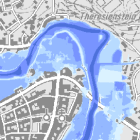
Wassertiefen - WMS
Die Darstellung der im Hochwasserfall eintretenden Wassertiefen erfolgt jeweils in fünf Klassen für ein häufiges Hochwasser (HQhäufig), ein 100-jährliches Hochwasser (HQ100) und ein Extremhochwasser (HQextrem). Durch die Darstellung der Wassertiefen können differenzierte Aussagen darüber getroffen werden, wie stark verschiedene Gebiete beim dargestellten Hochwasser betroffen sind. Maximale Bildgröße: 4096 x 4096 Pixel.
|
|
Citation proposal
(2013) . Wassertiefen - WMS. https://gdk.gdi-de.org/geonetwork/srv/api/records/a860f261-738d-4fff-a9f6-2e2c88c0ce34 |
INSPIRE
Identification
- File identifier
- a860f261-738d-4fff-a9f6-2e2c88c0ce34 XML
- Hierarchy level
- service Service
Online resource
Resource identifier
Encoding
- Format
- Sonstiges
Projection
Classification of data and services
Classification of data and services
- Service Type
- view
- Coupling Type
- Tight
Coupled resource
Coupled resource
Classification of data and services
- Service Type
- view
- Coupling Type
- Tight
Coupled resource
Coupled resource
Keywords
- Service Classification, version 1.0 ( Theme )
-
- infoMapAccessService
Other keywords
- Keywords
-
- gdiby
- Hochwasser
- Wasserstand
- Wasserhöhe
- Wassertiefe
- HQ100
- HQmittel
- HQhäufig
- HQ10
- HQ5
- HQ20
- HQextrem
- HQselten
- 100-jährlich
- Hochwassergefahr
- Hochwasserrisiko
- überschwemmungsgefährdet
- Überschwemmung
- Überflutung
- Überflutungstiefe
- Überflutungshöhe
- überflutungsgefährdet
- Bayern
Geographic coverage
N
S
E
W
))
Temporal reference
Temporal extent
Temporal extent
- Date ( Publication )
- 2013-09-11T00:00:00.000+02:00
Quality and validity
Conformity
Conformity
Conformity
Conformity
Conformity
Conformity
Restrictions on access and use
Restrictions on access and use
- Access constraints
- Creative Commons Namensnennung - Weitergabe unter gleichen Bedingungen 4.0 International (CC BY-SA 4.0); Datenquelle: Bayerisches Landesamt für Umwelt, www.lfu.bayern.de
- Access constraints
- {"id":"cc-by-sa/4.0","name":"Creative Commons Namensnennung - Weitergabe unter gleichen Bedingungen 4.0 International (CC BY-SA 4.0)","url":"https://creativecommons.org/licenses/by-sa/4.0/deed.de","quelle":"Bayerisches Landesamt für Umwelt, www.lfu.bayern.de"}
Responsible organization (s)
Contact for the resource
- Organisation name
- Bayerisches Landesamt für Umwelt
- Organisation name
- Bayerisches Landesamt für Umwelt
Responsible organization (s)
Contact for the resource
- Organisation name
- Bayerisches Landesamt für Umwelt
- Organisation name
- Bayerisches Landesamt für Umwelt
Metadata information
Contact for the metadata
- Organisation name
- Bayerisches Landesamt für Umwelt
- Date stamp
- 2024-06-28
- Metadata language
- German
SDS
Conformance class 1: invocable
Access Point URL
Endpoint URL
Technical specification
Conformance class 2: interoperable
Coordinate reference system
Quality of Service
Access constraints
- Access constraints
- otherRestrictions Other restrictions
Limitation
Use constraints
Limitation
- string
- Creative Commons Namensnennung - Weitergabe unter gleichen Bedingungen 4.0 International (CC BY-SA 4.0); Datenquelle: Bayerisches Landesamt für Umwelt, www.lfu.bayern.de
- string
- {"id":"cc-by-sa/4.0","name":"Creative Commons Namensnennung - Weitergabe unter gleichen Bedingungen 4.0 International (CC BY-SA 4.0)","url":"https://creativecommons.org/licenses/by-sa/4.0/deed.de","quelle":"Bayerisches Landesamt für Umwelt, www.lfu.bayern.de"}
Responsible custodian
Contact for the resource
Conformance class 3: harmonized
Contains Operations
- Operation Name
- GetCapabilities
- Distributed Computing Platforms
- Web services
- Operation Description
- application/vnd.ogc.wms_xml; text/xml;
- Connect Point
- https://www.lfu.bayern.de/gdi/wms/wasser/wassertiefen?
Contains Operations
- Operation Name
- GetMap
- Distributed Computing Platforms
- Web services
- Operation Description
- image/bmp; image/jpeg; image/tiff; image/png; image/png8; image/png24; image/png32; image/gif; image/svg+xml;
- Connect Point
- https://www.lfu.bayern.de/gdi/wms/wasser/wassertiefen?
Contains Operations
- Operation Name
- GetFeatureInfo
- Distributed Computing Platforms
- Web services
- Operation Description
- application/vnd.esri.wms_raw_xml; application/vnd.esri.wms_featureinfo_xml; application/vnd.ogc.wms_xml; text/xml; text/html; text/plain;
- Connect Point
- https://www.lfu.bayern.de/gdi/wms/wasser/wassertiefen?
Contains Operations
- Operation Name
- esri_wms:GetStyles
- Distributed Computing Platforms
- Web services
- Operation Description
- application/vnd.ogc.sld+xml;
- Connect Point
- https://www.lfu.bayern.de/gdi/wms/wasser/wassertiefen?
Overviews
Provided by

Views
a860f261-738d-4fff-a9f6-2e2c88c0ce34
Access to the portal
Read here the full details and access to the data.
Associated resources
Not available