 My GeoNetwork catalogue
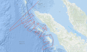
Processed seismic data of Cruise SO186 SeaCause II 2006
SeaCause cruise SO186-2, aboard the RV Sonne, was carried out off northern Sumatra between 21st January and 24th February 2006, with mobilisation and demobilisation in Singapore and Penang, Malaysia, respectively. The geophysical survey acquired multichannel seismic data (MCS) using a 240 channel, 3 km Sercel streamer, and a tuned airgun array comprising 16 airguns with a total capacity of 50.8 litres. Bathymetry data, using the 12 kHz Simrad swath system, subseabed data using the hull mounted high resolution Parasound profiler together with gravity and magnetic data were also acquired. The main scientific objective of the survey was to investigate the southern part of the rupture zone of the 26th December 2004 9.3 magnitude earthquake, that caused the catastrophic tsunami of that date, and the rupture zone of the 8.7 magnitude earthquake of March 28th 2005. Specifically, to identify the segment boundary between the two earthquakes, as recognised by the distribution of their aftershocks. This was to be achieved by mapping the structure of the subduction zone including the dip angle of the subducted plate, the architecture of the accretionary prism and the structure of the forearc basins, particularly their strike-slip fault systems. Also to be investigated was whether there was a contribution to the 2004 tsunami from major submarine failures. During the survey a total of 5358 line kilometres of MCS data were acquired, mainly on lines oriented orthogonal to the subduction zone and extending from the ocean basin across the trench and accretionary prism to the forearc basins offshore Sumatra. The orthogonal survey lines were located on average approximately 40 km apart. The survey was planned using the bathymetry from the HMS Scott, RV Natsushima and RV Sonne cruises carried out in 2004. The morphology of the trench and sediment thickness varies from north to south. In the north the trench is poorly defined with shallow seabed dip but with sediment thickness of ~3.5 secs (TWT). The seafloor dips increase southwards, but sediment thickness decreases to ~2.5 secs (TWT) off Nias. Both the ocean basin and trench sediments are dissected by numerous normal faults, oriented subparallel to the plate boundary, with many that penetrate the oceanic crust. In the south Fracture Zones were identified. The structure of the deformation front on the seaward margin of the accretionary prism is highly variable. While the younges main thrust are predominantly landward vergent there are examples for seaward verging thrusts. The frontal fold develops in some cases already in the french while in most cases the frontal fold is at the beginning of the accretionary wedge. At some locations there are large sediment slumps on the frontal thrusts, the slope angle of the prism varies between 6 to 15 degrees, an angle that explains the large scale slumping. The width of the accretionary prism is widest in the north of the area at 140 km and narrows southwards until in the vicinity of the islands it is 40 km. In the north and central parts of the survey area the passage from the deformation front landwards into the older prism is rapid and the seabed gradients steep. The dip of the oceanic crust remains low and there is an obvious twofold increase (6-7 seconds TWT) in the sediment thickness. The basal decollement of the thrusts at the deformation front is in the lower sediment layer overlying oceanic basement. This is traced northeastward. A possible explanation for the increase in thickness of the prism is therefore considered to be the formation of a thrust duplex. Perhaps this is due to the subducted sediment thickness. In this region the prism forms a plateau and the internal pattern of the uppermost sediments shows striking similarities to the trench fill. Offshore of Simeulue Island the prism structure changes and it forms the more usually seen taper. The offscraped sediment forms a thinner section, the thrusts are more steeply dipping. The dip of the subducted plate here is greater than in the north. Three forearc basins were surveyed. In the north the western margin of the Aceh Basin lies along the West Andaman Fault. Within the main basin the sediments are internally undeformed. Farther south in the Simeulue Basin the northern and central parts there are numerous, active steeply dipping faults. In southern part of the basin there is a transpressional fault similarly to the Mentawi Fault off southern Sumatra. There are notable ‘bright spots’ in the upper section that may indicate the presence of hydrocarbon gas. There are also widespread Bottom Simulating Reflectors indication the presence of gashydrates and there may be also one double BSR. At the southern end of the surveyed area the Nias Basin may be subdivided along its length into two parts by a northnorthwest to southsoutheast trending carbonate platform development. The basin has had a varying subsidence history, in the south the subsidence was completed before the northern part started.
Simple
- Alternate title
-
SO186 SeaCause II 2006
- Date (Creation)
- 2006-02-24
- Citation identifier
- 5493ad4b-98c2-6e6c-b55a-0b49bdd0d026
- Status
- Completed
-
GEMET - INSPIRE themes, version 1.0
-
-
Geologie
-
geology
-
-
GEMET - Concepts, version 2.4
-
-
geophysics
-
Geophysik
-
raw material
-
Rohstoff
-
- Theme
-
-
Marine geology
-
Meeresgeologie
-
Seismics
-
Seismik
-
Two-dimensional seismic reflection
-
zweidimensionale Reflektionsseismik
-
- Place
-
-
Indian Ocean
-
Sunda Arc
-
Indischer Ozean
-
Sundabogen
-
Sumatra
-
Simeulue
-
Nias
-
- Access constraints
- Other restrictions
- Other constraints
- Es gelten keine Zugriffsbeschränkungen
- Use constraints
- Other restrictions
- Other constraints
-
Allgemeine Geschäftsbedingungen, siehe http://www.bgr.bund.de/AGB - General terms and conditions, see http://www.bgr.bund.de/AGB_en . Die bereitgestellten Informationen sind bei Weiterverwendung wie folgt zu zitieren: Datenquelle: SO186 SeaCause II 2006, (c) BGR, Hannover, 2019
- Spatial representation type
- Vector
- Language
- English
- Character set
- UTF8
- Topic category
-
- Geoscientific information
))
- Unique resource identifier
- EPSG:4326
- Distribution format
-
-
Shapefile
(
n/a
)
-
Shapefile
(
n/a
)
- Transfer size
- 2
- OnLine resource
-
SO186 SeaCause II 2006 (Shapefile)
SO186 SeaCause II 2006 im Format ESRI Shape
- OnLine resource
- Profile BGR06-102
- OnLine resource
- Profile BGR06-105
- OnLine resource
- Profile BGR06-107
- OnLine resource
- Profile BGR06-109
- OnLine resource
- Profile BGR06-110
- OnLine resource
- Profile BGR06-112
- OnLine resource
- Profile BGR06-113
- OnLine resource
- Profile BGR06-115
- OnLine resource
- Profile BGR06-116
- OnLine resource
- Profile BGR06-117
- OnLine resource
- Profile BGR06-119
- OnLine resource
- Profile BGR06-120
- OnLine resource
- Profile BGR06-121
- OnLine resource
- Profile BGR06-122
- OnLine resource
- Profile BGR06-123
- OnLine resource
- Profile BGR06-128
- OnLine resource
- Profile BGR06-129
- OnLine resource
- Profile BGR06-130
- OnLine resource
- Profile BGR06-132
- OnLine resource
- Profile BGR06-133
- OnLine resource
- Profile BGR06-134
- OnLine resource
- Profile BGR06-135
- OnLine resource
- Profile BGR06-137
- OnLine resource
- Profile BGR06-138
- OnLine resource
- Profile BGR06-139
- OnLine resource
- Profile BGR06-140
- OnLine resource
- Profile BGR06-141
- OnLine resource
- Profile BGR06-142
- OnLine resource
- Profile BGR06-143
- OnLine resource
- Profile BGR06-144
- OnLine resource
- Profile BGR06-145
- OnLine resource
- Karte im BGR-Geoviewer
- Hierarchy level
- Dataset
Conformance result
- Date (Publication)
- 2010-12-08
- Explanation
-
siehe dazu die angegebene Durchführungsbestimmung
- Statement
-
During the period from 21st January to 24th February 2006 BGR acquired seismic lines off Sumatra during leg 2 of cruise SO186 with RV SONNE. The lines BGR06-101, BGR06-103, BGR06-104, BGR06-106, BGR06-108, BGR06-111, BGR06-114, BGR06-118, BGR06-124, BGR06-125, BGR06-126, BGR06-127, BGR06-131 and BGR06-136 are raw data. The line BGR06-102 consists of stacked data. The lines BGR06-105, BGR06-107, BGR06-109, BGR06-110, BGR06-112, BGR06-113, BGR06-115, BGR06-116, BGR06-117, BGR06-119, BGR06-120, BGR06-121, BGR06-122, BGR06-123, BGR06-128, BGR06-129, BGR06-130, BGR06-132, BGR06-133, BGR06-134, BGR06-135, BGR06-137, BGR06-138, BGR06-139, BGR06-140, BGR06-141, BGR06-142, BGR06-143, BGR06-144 and BGR06-145 are migrated data.
- File identifier
- a8fc19e4-6e03-4a1f-807a-7f75ab7d6982 XML
- Metadata language
- English
- Character set
- UTF8
- Parent identifier
-
Marine Seismic Survey Profiles (MSSP)
06a73c56-06a2-40d8-b806-466222b0760d
- Hierarchy level
- Dataset
- Hierarchy level name
-
Geophysik
- Date stamp
- 2023-11-16
- Metadata standard name
-
INSPIRE Metadata Implementing Rules: Technical Guidelines based on EN ISO 19115 and EN ISO 19119
- Metadata standard version
-
n/a
Overviews
Spatial extent
Provided by
