 www.geodatenkatalog.de (S3L)
Karte von Berlin 1:5000 (K5 SW-Ausgabe)
Landeskartenwerk mit administrativen Grenzen, Flurstücksgrenzen, Straßennamen, Grundstücksnummerierung. Hergestellt von den Vermessungsstellen der Bezirke auf Basis des Amtlichen LiegenschaftsKatasterInformationsSystems (ALKIS).
|
|
Citation proposal
(2025) . Karte von Berlin 1:5000 (K5 SW-Ausgabe). https://gdk.gdi-de.org/geonetwork/srv/api/records/ae016419-9585-398b-9f01-4b87a5b39d5e |
- Identification
- Distribution
- Quality
- Spatial rep.
- Ref. system
- Content
- Portrayal
- Metadata
- Md. constraints
- Md. maintenance
- Schema info
Identification
Identification info
Service Identification (19119)
Citation
- Date ( Publication )
- 2025-05-22
- Date ( Revision )
- 2024-01-02
- Presentation form
- Digital map
Point of contact
Point of contact
Point of contact
Point of contact
Point of contact
- Maintenance and update frequency
- As needed
- Keywords ( Theme )
-
- open data
- opendata
- Sachdaten
- Karten
- Geodaten
- Berlin
- Rasterkarte
- Kartenblätter
- 1:5.000
- ALK
- ALKIS
- K5
- Geobasiskarte
- Topografie
- Topographie
- Übersichtskarte
- Hintergrundkarte
- Grundkarte
- topographisch
- topografisch
- Räumlicher Anwendungsbereich ( Theme )
- Keywords
-
- infoMapAccessService
Legal constraints
- Access constraints
- Other restrictions
Legal constraints
- Use constraints
- Other restrictions
- Other constraints
- Nutzungsbedingungen: Für die Nutzung der Daten ist die Datenlizenz Deutschland - Namensnennung - Version 2.0 anzuwenden. Die Lizenz ist über https://www.govdata.de/dl-de/by-2-0 abrufbar. Der Quellenvermerk gemäß (2) der Lizenz lautet "Geoportal Berlin / [Titel des Datensatzes]". Werden auch Daten des Bundeslandes Brandenburg genutzt, ist der Quellenvermerk um den Hinweis "© GeoBasis-DE/LGB (2023), dl-de/by-2-0, Daten geändert" zu ergänzen.
- Other constraints
- {"id":"dl-by-de/2.0","name":"Datenlizenz Deutschland - Namensnennung - Version 2.0","url":"https://www.govdata.de/dl-de/by-2-0","quelle":"Geoportal Berlin / [Titel des Datensatzes]"}
- Service Type
- view
- Service Version
- OGC:WMS 1.0.0
- Service Version
- OGC:WMS 1.1.0
- Service Version
- OGC:WMS 1.1.1
- Service Version
- OGC:WMS 1.3.0
Extent
N
S
E
W
))
Geographic description
- Extent type code
- true
- Geographic identifier
- 110000000000
- Coupling Type
- Tight
Contains Operations
- Operation Name
- GetCapabilities
- Distributed Computing Platforms
- Web services
- Connect Point
- https://gdi.berlin.de/services/wms/k5_sw
- Operates On
Distribution
Distribution
- Distribution format
-
-
Text/HTML
(4.01 )
- Specification
- Keine Angabe
-
Text/HTML
(4.01 )
- OnLine resource
-
Darstellungsdienst - Karte von Berlin 1:5000 (K5 SW-Ausgabe) (WMS)
Darstellungsdienst - Karte von Berlin 1:5000 (K5 SW-Ausgabe) (WMS)
- OnLine resource
-
Darstellung der Karte im Geoportal Berlin
Darstellung der Karte im Geoportal Berlin
Quality
Scope
- Hierarchy level
- Service
- Other
- Dienst
Ref. system
- Reference system identifier
- http://www.opengis.net/def/crs/EPSG/0/25833
Metadata
Metadata
- File identifier
- ae016419-9585-398b-9f01-4b87a5b39d5e XML
- Metadata language
- German
- Character set
- UTF8
- Hierarchy level
- Service
- Hierarchy level name
- Karte von Berlin 1:5000 (K5) Dienst
- Date stamp
- 2025-11-19T00:00:00Z
- Metadata standard name
- ISO 19115/19119 - BE
- Metadata standard version
- 1.0.0
Point of contact
Overviews
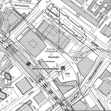
Vorschaubild
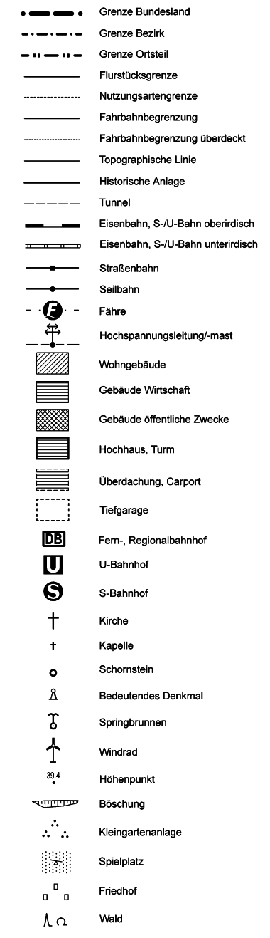
Legende
Provided by

Views
ae016419-9585-398b-9f01-4b87a5b39d5e
Access to the portal
Read here the full details and access to the data.
Associated resources
Not available