 www.geodatenkatalog.de (S1L)
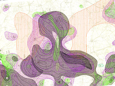
Lithofacial Map of the Quaternary 1 : 50.000 - Digitized data Sheet 1669 Brüssow
The Lithofacial Map of the Quaternary 1 : 50,000 (LKQ 50) is a map series of the GDR covering nearly the whole former state territory besides the South of Saxony and Thuringia. The series consists of 123 map sheets, each of which encompassing several horizon maps mostly complemented by about five cross sections. Specifications concerning map content and structure provides Cepek (1999). The data of the LKQ 50 map sheet 1669 Brüssow provided here were digitised in frame of the Geo3D-Oder project of the German Federal Institute for Geosciences and Natural Resources (BGR). The data include elements of the six horizon maps 1669-2, 1669-3, 1669-4, 1669-5, 1669-6 and 1669-7. The topics of these maps are defined in a general legend (version 3). Furthermore, the legends of the single horizon maps provide a stratigraphic and genetic classification of the depicted strata. For each horizon map the digitised elements comprise several polygon shapefiles of the single layers, a polyline shapefile of isohypses related to layer bases, a point shapefile of lithological profiles and a polygon shapefile of additional information concerning areas of heavy strata deformation and insufficient investigation. Non-numeric contents of the attribute tables are encoded by numbers and are translated in full text by means of key tables. The key table Normalprofil allows the stratigraphic and genetic classification of horizons displayed in horizon maps by code numbers of the column N_ID. Detailed descriptions concerning the data structure are provided in the attachments. Reference: Cepek, A. G. (1999): Die Lithofazieskarte Quartär 1 : 50.000 (LKQ 50) – Eine Erläuterung des Kartenkonzepts mit Hinweisen zum Gebrauch. - Brandenburgisch. Geowiss. Beitr. 6, 2: 3-38, 3 Abb., 2 Tab.; Kleinmachnow
|
|
Citation proposal
(2024) . Lithofacial Map of the Quaternary 1 : 50.000 - Digitized data Sheet 1669 Brüssow. https://gdk.gdi-de.org/geonetwork/srv/api/records/aed3a8a5-75eb-4be8-93a4-a10771e9add0 |
INSPIRE
Identification
- File identifier
- aed3a8a5-75eb-4be8-93a4-a10771e9add0 XML
- Hierarchy level
- Dataset
Online resource
Resource identifier
- Metadata language
- German
- Spatial representation type
- Vector
- Spatial representation type
- Grid
Encoding
- Format
- mxd
- Version
- 10.8
Projection
Classification of data and services
- Topic category
-
- Geoscientific information
Classification of data and services
Coupled resource
Coupled resource
Classification of data and services
Coupled resource
Coupled resource
Keywords
- GEMET - INSPIRE themes, version 1.0
-
- Geologie
Other keywords
- Keywords ( Theme )
-
- Quartär
Geographic coverage
N
S
E
W
))
Temporal reference
Temporal extent
Temporal extent
- Date ( Publication )
- 2024-02-09
Quality and validity
- Lineage
- Digitalisierung analoger Karten
- Denominator
- 50000
Conformity
Conformity
Conformity
Conformity
Conformity
Conformity
Restrictions on access and use
- Access constraints
- Allgemeine Geschäftsbedingungen, siehe https://www.bgr.bund.de/AGB - General terms and conditions, see https://www.bgr.bund.de/AGB_en. Die bereitgestellten Informationen sind bei Weiterverwendung wie folgt zu zitieren: Datenquelle: LKQ 50, (C) BGR, Hannover, 2024.
Restrictions on access and use
Responsible organization (s)
Contact for the resource
- Organisation name
- Bundesanstalt für Geowissenschaften und Rohstoffe (BGR)
- fis.hy@bgr.de
Responsible organization (s)
Contact for the resource
- Organisation name
- Bundesanstalt für Geowissenschaften und Rohstoffe (BGR)
- fis.hy@bgr.de
Metadata information
Contact for the metadata
- Organisation name
- Bundesanstalt für Geowissenschaften und Rohstoffe (BGR)
- Date stamp
- 2024-04-03
- Metadata language
- German
- Character set
- UTF8
SDS
Conformance class 1: invocable
Access Point URL
Endpoint URL
Technical specification
Conformance class 2: interoperable
Coordinate reference system
Quality of Service
Access constraints
Limitation
Use constraints
Limitation
Responsible custodian
Contact for the resource
Conformance class 3: harmonized
Overviews
Provided by

Views
aed3a8a5-75eb-4be8-93a4-a10771e9add0
Access to the portal
Read here the full details and access to the data.
Associated resources
Not available