 www.geodatenkatalog.de (S1L)
WMS Starkregen Bedburg-Hau
Der WMS (Web Map Service) ist eine standardisierte Schnittstelle zur Bereitstellung von Kartenausschnitten im Rasterformat. An einen WMS können mit verschiedenen Operationen (siehe Abschnitt Fachinformationen) Anfragen versendet werden. Üblicherweise übernimmt dies ein Geoinformationssystem, in welches die URL des WMS eingebunden wird.
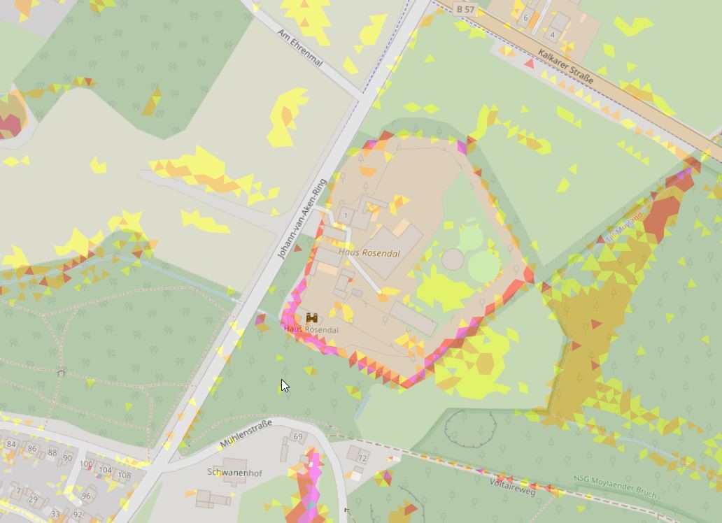
Der WMS Dienst zeigt die gezielte Suche nach Starkregensimulationen.
Zu sehen ist hier die Simulation von außergewöhnlichen Starkregen (T=100a) sowie zu Überschwemmungsgebieten bei Hochwasser im Bereich Bedburg-Hau.
Von Starkregen spricht man wenn, innerhalb kürzester Zeit, große Niederschlagsmengen fallen. Zudem kann langanhaltender Dauerregen, ebenfalls als Starkregen definiert werden.
|
|
Citation proposal
. WMS Starkregen Bedburg-Hau. Kreis Kleve - Der Landrat https://gdk.gdi-de.org/geonetwork/srv/api/records/af3a4fe0-24fe-44a9-9666-788dc2195206 |
- Identification
- Distribution
- Quality
- Spatial rep.
- Ref. system
- Content
- Portrayal
- Metadata
- Md. constraints
- Md. maintenance
- Schema info
Identification
Identification info
Service Identification (19119)
Citation
- Alternate title
- WMS Starkregen Bedburg-Hau
- Date ( Creation )
- 2023-05-04T00:00:00.000+02:00
Publisher
Point of contact
Maintenance information
- Maintenance and update frequency
- As needed
- Update scope
- Service
- Service Classification, version 1.0 ( Theme )
-
- infoMapAccessService
- Keywords
-
- Kreis Kleve
- Kleve
- NW
- NRW
- Nordrhein Westfalen
- Geoportal
- Klimakarte
- 051540004004
- Bedburg-Hau
- Bedburg Hau
- UMTHES Thesaurus ( Theme )
- GEMET - Concepts, version 3.1 ( Theme )
Legal constraints
- Use constraints
- Other restrictions
- Other constraints
- Datenlizenz Deutschland - Zero - Version 2.0 [https://www.govdata.de/dl-de/zero-2-0]
- Other constraints
- {"id":"dl-zero-de/2.0","name":"Datenlizenz Deutschland – Zero – Version 2.0","url":"https://www.govdata.de/dl-de/zero-2-0","quelle":""}
Legal constraints
- Access constraints
- otherRestrictions Other restrictions
- Service Type
- view
- Service Version
- OGC:WMS 1.3.0
Extent
Geographic description
- Extent type code
- true
- Geographic identifier
- Bedburg-Hau, Gemeinde (051540004004)
))
Bounding Polygon
- Extent type code
- true
Coupled Resource
- Operation Name
- GetCapabilities
Coupled Resource
- Operation Name
- GetMap
Coupled Resource
- Operation Name
- GetFeatureInfo
- Coupling Type
- Tight
Contains Operations
- Operation Name
- GetCapabilities
- Distributed Computing Platforms
- Web services
Contains Operations
- Operation Name
- GetMap
- Distributed Computing Platforms
- Web services
Contains Operations
- Operation Name
- GetFeatureInfo
- Distributed Computing Platforms
- Web services
- Operates On
Distribution
Distribution
- Distribution format
-
- ()
- OnLine resource
- Dienst "WMS Starkregen Bedburg-Hau" (GetCapabilities)
Metadata
Metadata
- File identifier
- af3a4fe0-24fe-44a9-9666-788dc2195206 XML
- Metadata language
- German
- Character set
- UTF8
- Hierarchy level
- service Service
- Hierarchy level name
- service
- Date stamp
- 2025-01-20
- Metadata standard name
- ISO19119
- Metadata standard version
- 2005/PDAM 1
Point of contact
Overviews
Provided by
