 www.geodatenkatalog.de (S1L)
Processed seismic data of Cruise BGR15-2 2015 (PANORAMA-2)
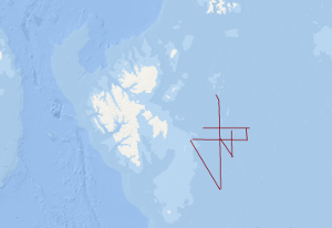
The PANORAMA-2 research cruise was carried out between August 15th and September 20th 2015 aboard the Italian research vessel OGS Explora, like the PANORAMA-1 cruise in 2013. The intended survey area was the European sector of the Arctic east and southeast of the Svalbard archipelago in the area of the northern Barents Sea. Main target of the PANORAMA-2 cruise was the acquisition of new geophysical data and the probing of surficial sediments in the underexplored area of the Sørkapp Basin and Olga Basin. In the course of the 20 day lasting Leg1 of the PANORAMA-2 cruise geophysical data acquisition was carried out. About 1750 km of 2D multi-channel seismic data were acquired and about 350 km of wide angle seismic data by means of sonobuoys. Sediment echosounder data, multi-beam data, gravity data and geomagnetic data were acquired during the entire cruise in a 24/7 mode within the survey area. After a 1-day stopover in Longyearbyen for a crew change of a part of the scientific crew, the research vessel OGS Explora returned to the survey area for another 11 days. During Leg-2 of the PANORAMA-2 cruise the surficial sediments were sampled by means of gravity corer, multi corer and dredge at 34 stations all together. Sediment sampling was carried out during day-light times only. Night times were used for acquisition of geomagnetic data, gravity data, sediment echosounder data and multi-beam data.
|
|
Citation proposal
. Processed seismic data of Cruise BGR15-2 2015 (PANORAMA-2). https://gdk.gdi-de.org/geonetwork/srv/api/records/afa19ad5-f3a7-4c45-be26-a0612fc6fa47 |
INSPIRE
Identification
- File identifier
- afa19ad5-f3a7-4c45-be26-a0612fc6fa47 XML
- Hierarchy level
- Dataset
Online resource
Resource identifier
- code
- 40a3ce1f-296e-5a6b-83fc-39ef255abd06
- Metadata language
- English
Encoding
- Format
- Shapefile
- Version
- n/a
Projection
Classification of data and services
- Topic category
-
- Geoscientific information
Classification of data and services
Coupled resource
Coupled resource
Classification of data and services
Coupled resource
Coupled resource
Keywords
- GEMET - INSPIRE themes, version 1.0 ( Theme )
-
- Geologie
- geology
- GEMET - Concepts, version 2.4 ( Theme )
-
- geophysics
- Geophysik
- raw material
- Rohstoff
Other keywords
- Keywords ( Theme )
-
- Marine geology
- Meeresgeologie
- Seismics
- Seismik
- Two-dimensional seismic reflection
- zweidimensionale Reflektionsseismik
- Keywords ( Place )
-
- Barents Sea
- Barentssee
- Spitzbergen
- Svalbard
Geographic coverage
N
S
E
W
))
Temporal reference
Temporal extent
Temporal extent
- Date ( Creation )
- 2015-09-20
Quality and validity
- Lineage
- During the period from the 15th of August to the 20th of September 2015 BGR acquired seismic lines east of Svalbard in the northern Barents Sea. The lines BGR15-203A, BGR15-204, BGR15-205, BGR15-205A, BGR15-206, BGR15-207, BGR15-207A, BGR15-208 and BGR15-209 consist of migrated data.
Conformity
Conformity
Conformity
Conformity
Conformity
Conformity
- Explanation
- siehe dazu die angegebene Durchführungsbestimmung
Restrictions on access and use
- Access constraints
- Allgemeine Geschäftsbedingungen, siehe https://www.bgr.bund.de/AGB - General terms and conditions, see https://www.bgr.bund.de/AGB_en. Die bereitgestellten Informationen sind bei Weiterverwendung wie folgt zu zitieren: Datenquelle: BGR15-2 2015 (PANORAMA-2), (c) BGR, Hannover, 2021
Restrictions on access and use
Responsible organization (s)
Contact for the resource
- Organisation name
- Federal Institute for Geosciences and Natural Resources
- Marine_Seismik@bgr.de
Responsible organization (s)
Contact for the resource
- Organisation name
- Federal Institute for Geosciences and Natural Resources
- Marine_Seismik@bgr.de
Metadata information
Contact for the metadata
- Organisation name
- Bundesanstalt für Geowissenschaften und Rohstoffe (BGR)
- Date stamp
- 2025-08-06
- Metadata language
- English
- Character set
- UTF8
SDS
Conformance class 1: invocable
Access Point URL
Endpoint URL
Technical specification
Conformance class 2: interoperable
Coordinate reference system
Quality of Service
Access constraints
Limitation
Use constraints
Limitation
Responsible custodian
Contact for the resource
Conformance class 3: harmonized
Overviews
Provided by

Views
afa19ad5-f3a7-4c45-be26-a0612fc6fa47
Access to the portal
Read here the full details and access to the data.
Associated resources
Not available