 My GeoNetwork catalogue
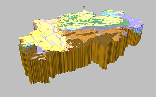
Geologisches 3D-Landesmodell von Nordrhein-Westfalen
Das Geologische 3D-Landesmodell stellt die geologischen Einheiten durch Gesteinsschichten sowie tektonische Störungszonen im dreidimensionalen Raum dar. Dadurch wird die Verbreitung von geologischen Strukturen im Untergrund sichtbar. Es handelt sich um ein Übersichtsmodell, welches nur die geologischen Hauptstrukturen vom paläozoischen Grundgebirge bis hin zu den allgemeinen Schichtenfolgen im Mesozoikum und Känozoikum abbildet. Es wurde mittels der 3D-Modellierungssoftware GOCAD in zwei Ausfertigungen erstellt: Das generalisierte Landesmodell beschränkt sich auf die Hauptstörungen und zeigt somit weniger komplex strukturierte Horizonte. Das Detail-Landesmodell zeigt den genauesten Kenntnisstand und befindet sich in Bearbeitung. Verfügbare geologische Haupteinheiten: Quartär, Tertiär, Oberkreide, Unterkreide, Jura, Buntsandstein, Zechstein, Rotliegend, Präperm, Karbon, Devon, Kambrium/Ordovizium.
INSPIRE
Identification
- File identifier
- b20b55d6-9d32-41e4-92f0-ce7cab79292b XML
- Hierarchy level
- Model
Online resource
Resource identifier
- Metadata language
- Deutsch
- Spatial representation type
- TIN
- Spatial representation type
- Grid
- Spatial representation type
- Vector
Encoding
- Format
-
ts
- Version
-
-
- Format
-
dxf
- Version
-
-
- Format
-
Raster
- Version
-
-
- Format
-
Geodatabase
- Version
-
10.x
- Format
-
Shape
- Version
-
-
Projection
- code
- 25832
Classification of data and services
- Topic category
-
- Geoscientific information
Classification of data and services
Coupled resource
Coupled resource
Classification of data and services
Coupled resource
Coupled resource
Keywords
-
GEMET - Concepts, version 3.1
-
-
Geologie
-
Tektonik
-
Modell
-
Other keywords
- Theme
-
-
DGM
-
Modellierung
-
Störungen
-
regionale Störungen
-
überregionale Störungen
-
Horizonte
-
Verbreitungen
-
Isolinien
-
Tiefenisolinien
-
Mächtigkeit
-
Versatz
-
Geographic coverage
))
Temporal reference
Temporal extent
Temporal extent
- Date (Revision)
- 2018-05-16
Quality and validity
- Lineage
-
Geologische Karte von NRW 1:50.000 incl. Schnittserienkarten, Geologische Karte von NRW 1:100.000 incl. Schnittserienkarten, Geologische Karte von NRW 1:500.000 incl. Schnittserienkarten, Auswertung der Bohrungsdatenbank des Geologischen Dienstes, Ergebnisse der Integrierten Geologischen Landesaufnahme
- Denominator
- 100000
- Denominator
- 500000
- Denominator
- 50000
Conformity
Conformity
Conformity
Conformity
Conformity
Conformity
Restrictions on access and use
- Access constraints
-
auf Anfrage
Responsible organization (s)
Contact for the resource
- Organisation name
-
Geologischer Dienst NRW
Responsible organization (s)
Contact for the resource
- Organisation name
-
Geologischer Dienst NRW
Metadata information
Contact for the metadata
- Organisation name
-
Geologischer Dienst NRW
- Date stamp
- 2025-03-28
- Metadata language
- Deutsch
- Character set
- UTF8
SDS
Conformance class 1: invocable
Access Point URL
Endpoint URL
Technical specification
Conformance class 2: interoperable
Access constraints
Limitation
Use constraints
Limitation
Responsible custodian
Contact for the resource
Overviews
Spatial extent
Provided by
