 www.geodatenkatalog.de (S3L)
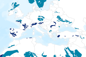
Global Distribution of Precambrian Rocks (Precam)
The Map of the Worldwide Distribution of Precambrian Rocks is a general map which shows Precambrian rocks, partly under Quaternary sediments. The map is based on data of the Geological Map of the World (Bouysse 2010) of the Commission of the Geological Map of the World (CGMW). It also displays rock units that contain other rocks in addition to Precambrian rocks.
|
|
Citation proposal
(2020) . Global Distribution of Precambrian Rocks (Precam). https://gdk.gdi-de.org/geonetwork/srv/api/records/b44d8606-d982-42ad-a54c-44acc89c0028 |
Simple
- Alternate title
- Precam
- Date ( Publication )
- 2020-05-13
- Edition
- 1. Auflage
- Identifier
- daac0052-0823-4850-1e7c-5096cb4d746d
Author
Author
- Status
- completed Completed
Point of contact
Bundesanstalt für Geowissenschaften und Rohstoffe
-
Asch, Kristine, Dr.
Stilleweg 2
Hannover
30655
DE
- GEMET - INSPIRE themes, version 1.0 ( Theme )
-
- Geologie
- Geology
- Keywords ( Place )
-
- Welt
- Keywords ( Theme )
-
- Präkambrium
- on-shore
- Gestein
- Karte
- Access constraints
- Other restrictions
- Use constraints
- Other restrictions
- Other constraints
- Allgemeine Geschäftsbedingungen, s. https://www.bgr.bund.de/agb - General Terms and Conditions, s. https://www.bgr.bund.de/agb_en
- Spatial representation type
- Grid
- Denominator
- 70000000
- Metadata language
- ger German
- Character set
- utf8 UTF8
- Topic category
-
- Geoscientific information
N
S
E
W
))
- Distribution format
-
- PDF (n/a )
- Transfer size
- 4
- OnLine resource
-
Precam (PDF)
Precam im Format PDF
- OnLine resource
-
Karte im BGR-Geoviewer
Karte im BGR-Geoviewer
- Hierarchy level
- Dataset
Conformance result
- Date ( Publication )
- 2010-12-08
- Explanation
- siehe dazu die angegebene Durchführungsbestimmung
- Statement
- Die Karte entstand unter Nutzung von Bouysse, P. et al. (2010): Geological Map of the World. Commission of the Geological Map of the World (CGMW), Paris, und auf der topographischen Basis: Esri, HERE, Garmin, FAO, NOAA, USGS, (C) OpenStreetMap contriburors and the GIS User Community
gmd:MD_Metadata
- File identifier
- b44d8606-d982-42ad-a54c-44acc89c0028 XML
- Metadata language
- German
- Character set
- utf8 UTF8
- Hierarchy level
- dataset Dataset
- Hierarchy level name
- Geologie
- Date stamp
- 2020-05-13
- Metadata standard name
- INSPIRE Metadata Implementing Rules: Technical Guidelines based on EN ISO 19115 and EN ISO 19119
- Metadata standard version
- n/a
Point of contact
Overviews
Provided by

Views
b44d8606-d982-42ad-a54c-44acc89c0028
Access to the portal
Read here the full details and access to the data.
Associated resources
Not available