 www.geodatenkatalog.de (S3F)
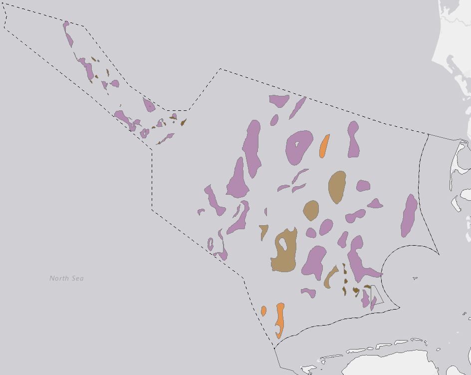
CO2 storage potential of the Middle Buntsandstein Subgroup - EEZ of the German North Sea
The CO2 storage potential of the Middle Buntsandstein Subgroup within the Exclusive Economic Zone (EEZ) of the German North Sea was analysed within the framework of the GEOSTOR-Project. A total of 71 potential storage sites were mapped based on existing 3D models, seismic and well data. Static CO2 capacities were calculated for each structure using Monte Carlo simulations with 10,000 iterations to account for uncertainties. All potential reservoirs were evaluated based on their static capacity, burial depth, top seal integrity and trap type. Analysis identified 38 potential storage sites with burial depths between 800 m and 4500 m, reservoir capacities (P50) above 5 Mt CO2 and suitable sealing units. The best storage conditions are expected on the West Schleswig Block where salt-controlled anticlines with moderate burial depths, large reservoir capacities and limited lateral flow barriers are the dominant trap types. Relatively poor storage conditions can be anticipated for small (P50 <5 Mt CO2), deeply buried (> 4500 m) and structurally complex potential storage sites in the Horn and Central Graben. For more detailed information on the methodology and findings, please refer to the full publication: Fuhrmann, A., Knopf, S., Thöle, H., Kästner, F., Ahlrichs, N., Stück, H. L., Schlieder-Kowitz, A. und Kuhlmann, G. (2024) CO2 storage potential of the Middle Buntsandstein Subgroup - German sector of the North Sea. Open Access International Journal of Greenhouse Gas Control, 136 . Art.Nr. 104175. DOI 10.1016/j.ijggc.2024.104175
|
|
Citation proposal
(2024) . CO2 storage potential of the Middle Buntsandstein Subgroup - EEZ of the German North Sea. https://gdk.gdi-de.org/geonetwork/srv/api/records/b476ad13-45bc-479b-acbe-dce39e91f7ce |
Simple
- Alternate title
- SpPotMBst
- Date ( Publication )
- 2024-07-31
- Identifier
- 9e366762-9b07-ed98-4fc1-2f4f2e23c3db
Author
Author
Author
Author
Author
Author
Author
- Status
- completed Completed
Point of contact
- GEMET - INSPIRE themes, version 1.0 ( Theme )
-
- Geology
- Geologie
- Keywords ( Theme )
-
- CO2 storage capacity
- Carbon capture and storage (CCS)
- Buntsandstein
- German North Sea
- Reservoir evaluation
- Saline aquifers
- opendata
- Keywords ( Place )
-
- EEZ of the German North Sea
- Access constraints
- Other restrictions
- Use constraints
- Other restrictions
- Other constraints
- { "id": "dl-by-de/2.0", "name": "Datenlizenz Deutschland Namensnennung 2.0", "url": "https://www.govdata.de/dl-de/by-2-0", "quelle": "GEOSTOR-SpPotMBst, BGR, 2024" }
- Spatial representation type
- Vector
- Metadata language
- English
- Character set
- UTF8
- Topic category
-
- Geoscientific information
N
S
E
W
))
- Distribution format
-
- WMS (OGC:WMS 1.3.0 )
- FileGDB (n/a )
- OnLine resource
-
BGR-Projektseite
BGR-Projektseite
- OnLine resource
-
Geostor-Webseite
Geostor-Webseite
- OnLine resource
-
Geostor-Datenkatalog
Geostor-Datenkatalog
- OnLine resource
-
International Journal of Greenhouse Gas Control, No. 136
International Journal of Greenhouse Gas Control, No. 136
- OnLine resource
-
Daten im Format FileGDB
Daten (FileGDB)
- OnLine resource
-
Karte im BGR-Geoviewer
Karte im BGR-Geoviewer
- Hierarchy level
- Dataset
- Statement
- Basierend auf seismischen Daten und Bohrungen, die entsprechend der Richtlinien des GeolDG frei verfügbar sind.
gmd:MD_Metadata
- File identifier
- b476ad13-45bc-479b-acbe-dce39e91f7ce XML
- Metadata language
- English
- Character set
- UTF8
- Parent identifier
- ec1975a4-e9ac-44be-b19f-f6e01ef5177f
- Hierarchy level
- Dataset
- Hierarchy level name
- Geologie
- Date stamp
- 2024-11-21
- Metadata standard name
- INSPIRE Metadata Implementing Rules: Technical Guidelines based on EN ISO 19115 and EN ISO 19119
- Metadata standard version
- n/a
Point of contact
Overviews
Provided by

Views
b476ad13-45bc-479b-acbe-dce39e91f7ce
Access to the portal
Read here the full details and access to the data.
Associated resources
Not available