 www.geodatenkatalog.de (S1L)
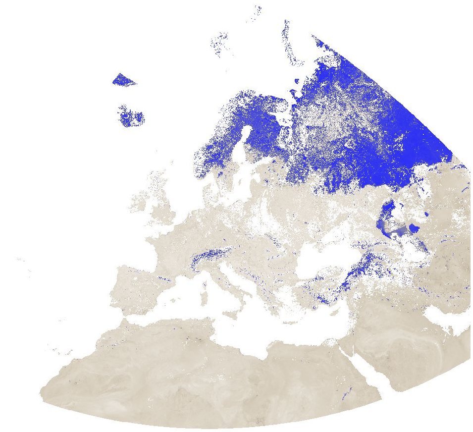
MODIS MNDWI, 8-day time series for Europe at 1 km resolution
Modified Normalized Difference Water Index (MNDWI) from MODIS data for Europe at 1 km resolution.
Source data:
- MODIS/Terra Surface Reflectance 8-Day L3 Global 500 m SIN Grid (MOD09A1 v006): https://lpdaac.usgs.gov/products/mod09a1v006/
The corresponding MODIS/Aqua product (MYD09A1 v006) could not be used due to the fact that the Aqua satellite has a number of broken detectors resulting in unreliable data for band 6 (SWIR) measurements.
The Moderate Resolution Imaging Spectroradiometer (MODIS) Terra MOD09A1 Version 6 product provides an estimate of the surface spectral reflectance of Terra MODIS Bands 1 through 7 corrected for atmospheric conditions such as gasses, aerosols, and Rayleigh scattering. Along with the seven 500 meter (m) reflectance bands are two quality layers and four observation bands. For each pixel, a value is selected from all the acquisitions within the 8-day composite period. The criteria for the pixel choice include cloud and solar zenith. When several acquisitions meet the criteria the pixel with the minimum channel 3 (blue) value is used.
For the time periods October 2016 - March 2017 and August 2020 - April 2021, the original data has been reprojected to ETRS89-extended / LAEA Europe and aggregated to a 1 km grid. The temporal resolution is 8 days. Bad quality pixels (cloud, cloud shadow, dead detector, solar zenith angle too large, etc.) have been masked using the provided quality assurance (QA) layers and appear as "no data".
File naming:
productCode.acquisitionDate[A (YYYYDDD)]_mosaic_spatialResolution_frequency_VI.tif
example: MOD09A1.A2016353_mosaic_1000m_8_days_MNDWI.tif
The date is Year and Day of Year.
Values are MNDWI * 10000. Example: Value -5099 = -0.5099
|
|
Citation proposal
(2021) . MODIS MNDWI, 8-day time series for Europe at 1 km resolution. https://gdk.gdi-de.org/geonetwork/srv/api/records/b4bfcab8-7dad-4bf2-961e-a1615c2ac67f |
INSPIRE
Identification
- File identifier
- b4bfcab8-7dad-4bf2-961e-a1615c2ac67f XML
- Hierarchy level
- Dataset
Online resource
- Protocol
- WWW:DOWNLOAD-1.0-http--download
- Protocol
- WWW:DOWNLOAD-1.0-http--download
- Protocol
- WWW:DOWNLOAD-1.0-http--download
Resource identifier
- code
- 10.5281/zenodo.6573878
- Metadata language
- English
- Spatial representation type
- Grid
Encoding
- Format
- GeoTIFF
- Version
Projection
Classification of data and services
- Topic category
-
- Geoscientific information
Classification of data and services
Coupled resource
Coupled resource
Classification of data and services
Coupled resource
Coupled resource
Keywords
- GEMET - INSPIRE themes, version 1.0 ( Theme )
-
- Land cover
Other keywords
- Keywords ( Theme )
-
- MNDWI
- Water Index
- Keywords ( Place )
-
- Europe
- Keywords ( Theme )
-
- MOOD-H2020
- Avian Flu
- Tularaemia
- Leptospirosis
- Lyme
- TBE
- WNV
- USUTU
- Mosquito borne Flaviviruses
Geographic coverage
))
Temporal reference
Temporal extent
Temporal extent
- Date ( Publication )
- 2021-10-29
Quality and validity
- Lineage
- Derived from MODIS Terra Surface Reflectance 8-Day L3 Global 500 m SIN Grid. Bad quality pixels (cloud, cloud shadow, dead detector, solar zenith angle too large, etc.) have been masked using the provided quality assurance (QA) layers.
- Distance
- 1 km
Conformity
Conformity
Conformity
Conformity
Conformity
Conformity
- Explanation
- See specified reference
Restrictions on access and use
- Access constraints
- All data products distributed by NASA's Land Processes Distributed Active Archive Center (LP DAAC) are available at no charge.
- Access constraints
-
All LP DAAC current data and products acquired through the LP DAAC have no restrictions on reuse, sale, or redistribution.
The LP DAAC requests that any author using NASA data products in their work provide credit for the data, and any assistance provided by the LP DAAC, in the data section of the paper, the acknowledgement section, and/or as a reference. The recommended citation for each data product is available on its Digital Object Identifier (DOI) Landing page, which can be accessed through the Search Data Catalog interface.
For full information on LP DAAC Data Citation and Policies, see: https://lpdaac.usgs.gov/data/data-citation-and-policies/
Restrictions on access and use
Responsible organization (s)
Contact for the resource
- Organisation name
- mundialis GmbH & Co. KG
- info@mundialis.de
Responsible organization (s)
Contact for the resource
- Organisation name
- mundialis GmbH & Co. KG
- info@mundialis.de
Metadata information
Contact for the metadata
- Organisation name
- mundialis GmbH & Co. KG
- info@mundialis.de
- Date stamp
- 2023-12-15T14:07:33
- Metadata language
- English
- Character set
- UTF8
SDS
Conformance class 1: invocable
Access Point URL
Endpoint URL
Technical specification
Conformance class 2: interoperable
Coordinate reference system
Quality of Service
Access constraints
Limitation
Use constraints
Limitation
Responsible custodian
Contact for the resource
Conformance class 3: harmonized
Overviews
Provided by
