 www.geodatenkatalog.de (S2F)
Lagefestpunktfeld - Saarland
Die LFP sind Festpunkte, die in der Örtlichkeit dauerhaft vermarkt sind und deren Koordinaten, Höhen und ggfs. Schwerewerte bestimmt sind. Die Koordinaten der LFP des " Übergeordneten Festpunktfeldes " (ÜFP) sind grundsätzlich durch GPS-Messung bestimmt. Da die LFP früher durch trigonometrische Feldmessung bestimmt wurden, spricht man auch von " Trigonometrischen Punkten " (TP). Ihr Nachweis der LFP umfasst: - Punktdaten in Form von Lagekoordinaten, Höhen- und Schwerewerten - Punktbeschreibungen (Einmessungsskizzen) - Punktübersichten: Top. Karte 1: 25 000 mit eingezeichneten Punktsignaturen und -nummern
|
|
Citation proposal
. Lagefestpunktfeld - Saarland. https://gdk.gdi-de.org/geonetwork/srv/api/records/b508269f-56e0-445c-8eb8-8eba0af09ab4 |
INSPIRE
Identification
- File identifier
- b508269f-56e0-445c-8eb8-8eba0af09ab4 XML
- Hierarchy level
- Dataset
Online resource
Resource identifier
- Metadata language
- German
- Spatial representation type
- Text, table
Encoding
- Format
- Texttabelle
- Version
- 1.0
- Specification
- Format
- Übersichtskarte
- Version
- 1.0
- Specification
Projection
Classification of data and services
- Topic category
-
- Imagery base maps earth cover
Classification of data and services
Coupled resource
Coupled resource
Classification of data and services
Coupled resource
Coupled resource
Keywords
Other keywords
- Keywords ( Theme )
-
- Festpunkte Höhenfestpunkt Lagefestpunkt Schwerefestpunkt
- Keywords ( Place )
-
- Saarland
- Keywords
-
- AdVMIS
- geoportal
Geographic coverage
Temporal reference
Temporal extent
Temporal extent
- Date ( Creation )
- 2013-11-07
- Date ( Revision )
- 2022-06-22
Quality and validity
- Lineage
- Felderfassung der Messdaten durch örtliche GPS - und Zentrieungsmessungen und Berechnung
- Denominator
- 1
Conformity
Conformity
Conformity
Conformity
Conformity
Conformity
Restrictions on access and use
Restrictions on access and use
Responsible organization (s)
Contact for the resource
- Organisation name
- Landesamt für Vermessung, Geoinformation und Landentwicklung
Responsible organization (s)
Contact for the resource
- Organisation name
- Landesamt für Vermessung, Geoinformation und Landentwicklung
Metadata information
Contact for the metadata
- Organisation name
- Landesamt für Vermessung, Geoinformation und Landentwicklung
- Date stamp
- 2025-06-25T05:17:04.268765Z
- Metadata language
- German
SDS
Conformance class 1: invocable
Access Point URL
Endpoint URL
Technical specification
Conformance class 2: interoperable
Coordinate reference system
Quality of Service
Access constraints
Limitation
Use constraints
Limitation
Responsible custodian
Contact for the resource
Conformance class 3: harmonized
Overviews
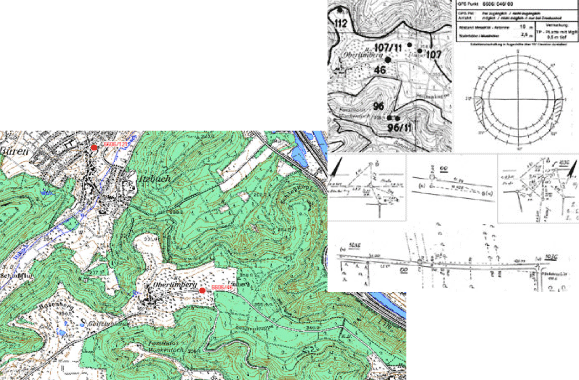
Ausschnitt Übersicht und Beschreibung
Provided by

Views
b508269f-56e0-445c-8eb8-8eba0af09ab4
Access to the portal
Read here the full details and access to the data.
Associated resources
Not available