 www.geodatenkatalog.de (S3F)
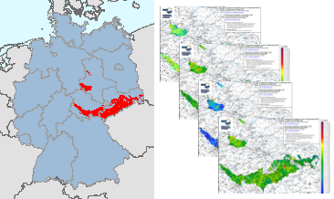
Geochemical Atlas of the Federal Republic of Germany (1985), Gallium in stream sediments, Single element maps
In the former GDR, investigations were carried out between 1980 and 1990 to estimate the raw material potential in the pre-Upper Permian bedrock units (Flechtingen-Rosslau Hills, Harz Mountains, Saxon Granulite Mountains, Thuringian Forest, Thuringian-Vogtlandian Slate Mountains, Ore Mountains, Elbe Valley Region/Lusatia), which lie at the earth's surface or are slightly covered by the Cenozoic. Part of these investigations was a geochemical prospection in the area of the above mentioned bedrock units. Approximately 18,000 water and 17,500 stream sediment samples were taken and geochemically analysed over an area of almost 15,000 km². The results of these investigations were documented in sub-reports on the individual bedrock units as well as in the "Final Report on the Comparative Evaluation of the Raw Material Potential in the Bedrock Units of the GDR" (Röllig et al., 1990; in German). These data from the bedrock units in the southern part of the former GDR are unique in their high sampling density (> 1 sample/km²) and provide a comprehensive geochemical survey of these areas. All later geochemical investigations (Geochemical Atlas 2000 as well as within the framework of GEMAS and FOREGS) were carried out with a much lower sampling density. These valuable and irretrievable data are now made generally available via the BGR geoportal. In addition to the digital provision of the original data material, area-wide distribution maps are made available for the first time, which were generated using modern computer-assisted methods. The downloads show the distribution of Gallium contents in stream sediments in four different coloured point and colour shaded contour maps.
|
|
Citation proposal
(2023) . Geochemical Atlas of the Federal Republic of Germany (1985), Gallium in stream sediments, Single element maps. https://gdk.gdi-de.org/geonetwork/srv/api/records/b56d6616-edb1-4e61-b17e-b3970c9febe1 |
INSPIRE
Identification
- File identifier
- b56d6616-edb1-4e61-b17e-b3970c9febe1 XML
- Hierarchy level
- dataset Dataset
Online resource
Resource identifier
- Metadata language
- eng German
- Spatial representation type
- Grid
- Spatial representation type
- Vector
Encoding
- Format
- Shapefile
- Version
- n/a
- Format
- Version
- n/a
- Format
- PNG
- Version
- n/a
Projection
Classification of data and services
- Topic category
-
- Geoscientific information
Classification of data and services
Coupled resource
Coupled resource
Classification of data and services
Coupled resource
Coupled resource
Keywords
Other keywords
- Keywords ( Theme )
-
- Atlas
- Bachsedimente
- Geochemie
- Geochemische Karte
- Elementkonzentration
- Gallium
- flächenhafte Verteilung
- Prospektion
- Umweltgeochemie
- atlas
- stream sediments
- geochemistry
- geochemical map
- element concentration
- spatial distribution
- prospection
- environmental geochemistry
- Keywords ( Place )
-
- Deutschland
- Germany
Geographic coverage
N
S
E
W
))
Temporal reference
Temporal extent
Temporal extent
- Date ( Publication )
- 2023-10-31
Quality and validity
- Lineage
- Röllig, G., Berger, W., Birke, M., Enderlein, F., Grosche, G., Kaberdin, B., Kampe, A., Krull, P., Kruse, B., Kunz, I., Rauch, U., Rentzsch, J., Schwandtke, E., Sehm, K., Söllig, A., Thomas, U. & Wünsch, K. (1990): Abschlußbericht zur vergleichenden Bewertung der Rohstofführung in den Grundgebirgseinheiten im Südteil der DDR. Gesellschaft für Umwelt- und Wirtschaftsgeologie mbH: S. 807; Berlin (Archiv der Bundesanstalt für Geowissenschaften und Rohstoffe, Hannover, Archivnummer 1004927).
- Denominator
- 1000000
Conformity
Conformity
Conformity
Conformity
Conformity
Conformity
- Explanation
- siehe dazu die angegebene Durchführungsbestimmung
Restrictions on access and use
- Access constraints
- Allgemeine Geschäftsbedingungen, s. https://www.bgr.bund.de/agb - General Terms and Conditions, s. https://www.bgr.bund.de/agb_en
Restrictions on access and use
Responsible organization (s)
Contact for the resource
- Organisation name
- Bundesanstalt für Geowissenschaften und Rohstoffe/Federal Institute for Geosciences and Natural Resources
Responsible organization (s)
Contact for the resource
- Organisation name
- Bundesanstalt für Geowissenschaften und Rohstoffe/Federal Institute for Geosciences and Natural Resources
Metadata information
Contact for the metadata
- Organisation name
- Bundesanstalt für Geowissenschaften und Rohstoffe (BGR)
- Date stamp
- 2025-03-10
- Metadata language
- German
- Character set
- utf8 UTF8
SDS
Conformance class 1: invocable
Access Point URL
Endpoint URL
Technical specification
Conformance class 2: interoperable
Coordinate reference system
Quality of Service
Access constraints
Limitation
Use constraints
Limitation
Responsible custodian
Contact for the resource
Conformance class 3: harmonized
Overviews
Provided by

Views
b56d6616-edb1-4e61-b17e-b3970c9febe1
Access to the portal
Read here the full details and access to the data.
Associated resources
Not available