 My GeoNetwork catalogue
Processed seismic data of Cruise SO27 1983
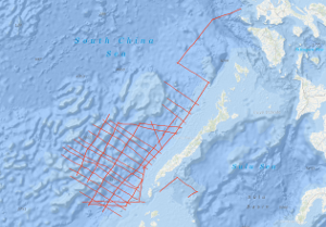
As recommended by the Joint CCOP-IOC Working Group on Post-IDOE Studies on East Asia Tectonics and Resources and the proposal of the Bureau of Mines and Geosciences of the Philippines to extend the research of the previous R/V SONNE survey SO-23, the Federal Institute of Geosciences and Natural Resources (BGR) carried out a geophysical survey in the southeastern part of the South China Sea (Dangerous Grounds) and in the northwestern part of the Sulu Sea in two legs from 29th April to 29th June 1983 on SONNE cruise SO-27. Multichannel reflection seismic measurements were carried out in parallel with magnetic, gravimetric, Sea-Beam, and 3.5 kHz subbottom profiler measurements on 34 lines with a total length of 7,204 km. In addition, 26 lines with a total length of 2,800 km were surveyed with only the last four named methods. SONNE cruise SO-27 was financed by the Federal Ministry of Research and Technology (BMFT). Six seismic sequences (DG-1 to DG-6) (DG = Dangerous Grounds) could be distinguished in the surveyed part of the South China Sea. The oldest recognizable sequence is the sequence DG-6, an equivalent of the Pre-Nido Formation of the northwest shelf of Palawan. Seismic unconformity Violet marks the top of the DG-6 sequence, which consists of a complex system of tilted horsts and half-grabens. The half-grabens are presumably filled with clastic sediments of Eocene age (seismic sequence DG-5). The top of seismic sequence DG-5 is bounded by unconformity Blue, which is interpreted as representing the end of the rift phase and the onset of seafloor spreading in the South China Sea about 32 m.y. ago. The overlying seismic sequence DG-4 is characterized by an internal reflection pattern with low frequencies. Lithologically, this sequence consists of shallow-water carbonates with reef complexes of Oligocene to Early Miocene age and has to be regarded as equivalent to the oil-containing Nido Formation of the Palawan shelf. A rapid subsidence of large parts of the survey area during the late (?) Early Miocene ended the growth of the shallow water carbonate platform, indicated by the unconformity Blue. The overlying seismic sequence DG-3 is interpreted as consisting of a transitional facies between a shallow water and a bathyal depositional environment. The top of this sequence is marked by unconformity Red, which most probably represents the end of the drifting phase (seafloor spreading) in the South China Sea during the Middle Miocene. The most prominent structural feature of the shelf and slope of central and southern Palawan is a thick sedimentary wedge originally interpreted as a melange. Our data show that the Oligocene to Early Miocene carbonate platform of the Dangerous Grounds extends beneath the Palawan Trough, as well as beneath the central and southern Palawan shelf, underlying the melange. Based on the finding that i) Rhaeto-Liassic rocks are present in the Dangerous Grounds, ii) the Oligocene to Early Miocene carbonate platform continues from the Dangerous Grounds through the Palawan Trough to the central and southern Palawan shelf, and iii) there is thinned continental crust 20 km thick below the continental slope of southern Palawan, we believe the Dangerous Grounds, together with Palawan and the Caiman Islands belong to a uniform continental fragment which separated from the proto-chinese continental margin when the South China Sea opened during the Oligocene. Previously, the melange of central and southern Palawan, which contains ophiolites, was interpreted as being autochthonous. In our opinion, the melange is an allochthonous mass which has been overthrusted onto the eastern margin of the Dangerous Grounds-Palawan-Caiman microcontinent from the Northwest Sulu Basin. The Ulugan Bay fault is interpreted as the northeastern front of this allochthonous mass. The area of prospective carbonate plays is considerably enlarged by the discovery that the Oligocene to Early Miocene carbonate platform with Nido-type reef structures extends below the allochthonous sediments of central and southern Palawan. We expect that hydrocarbon-bearing structures of the Sabah-type, i. e. thick, folded Neogene sediments, will be found in the western part of the northwestern Sulu basin. If our interpretation is correct, a new chapter of hydrocarbon exploration may be about to begin around Palawan in the Philippines.
Simple
- Alternate title
-
SO27 1983
- Date (Creation)
- 1983-06-29
- Citation identifier
- 0c1ad2fb-8495-1b84-b45e-9a2a37aed7d4
- Status
- Completed
-
GEMET - INSPIRE themes, version 1.0
-
-
Geologie
-
geology
-
-
GEMET - Concepts, version 2.4
-
-
geophysics
-
Geophysik
-
raw material
-
Rohstoff
-
- Theme
-
-
Marine geology
-
Meeresgeologie
-
Seismics
-
Seismik
-
Two-dimensional seismic reflection
-
zweidimensionale Reflektionsseismik
-
- Place
-
-
South China Sea
-
Südchinesisches Meer
-
Sulu Sea
-
Sulu-See
-
Palawan
-
- Access constraints
- Other restrictions
- Other constraints
- Es gelten keine Zugriffsbeschränkungen
- Use constraints
- Other restrictions
- Other constraints
-
Allgemeine Geschäftsbedingungen, siehe http://www.bgr.bund.de/AGB - General terms and conditions, see http://www.bgr.bund.de/AGB_en . Die bereitgestellten Informationen sind bei Weiterverwendung wie folgt zu zitieren: Datenquelle: SO27 1983, (c) BGR, Hannover, 2019
- Spatial representation type
- Vector
- Language
- English
- Character set
- UTF8
- Topic category
-
- Geoscientific information
))
- Unique resource identifier
- EPSG:4326
- Distribution format
-
-
Shapefile
(
n/a
)
-
Shapefile
(
n/a
)
- Transfer size
- 2
- OnLine resource
-
SO27 1983 (Shapefile)
SO27 1983 im Format ESRI Shape
- OnLine resource
- Profile SO27-01
- OnLine resource
- Profile SO27-02
- OnLine resource
- Profile SO27-03
- OnLine resource
- Profile SO27-04
- OnLine resource
- Profile SO27-05
- OnLine resource
- Profile SO27-06
- OnLine resource
- Profile SO27-07
- OnLine resource
- Profile SO27-08
- OnLine resource
- Profile SO27-08A
- OnLine resource
- Profile SO27-09
- OnLine resource
- Profile SO27-10
- OnLine resource
- Profile SO27-11
- OnLine resource
- Profile SO27-12
- OnLine resource
- Profile SO27-15
- OnLine resource
- Profile SO27-16
- OnLine resource
- Profile SO27-19
- OnLine resource
- Profile SO27-20
- OnLine resource
- Profile SO27-21
- OnLine resource
- Profile SO27-22
- OnLine resource
- Profile SO27-23
- OnLine resource
- Profile SO27-24
- OnLine resource
- Profile SO27-25
- OnLine resource
- Profile SO27-26
- OnLine resource
- Profile SO27-27
- OnLine resource
- Profile SO27-28
- OnLine resource
- Profile SO27-29
- OnLine resource
- Profile SO27-30
- OnLine resource
- Profile SO27-31
- OnLine resource
- Profile SO27-32
- OnLine resource
- Profile SO27-33
- OnLine resource
- Profile SO27-33A
- OnLine resource
- Profile SO27-34
- OnLine resource
- Karte im BGR-Geoviewer
- Hierarchy level
- Dataset
Conformance result
- Date (Publication)
- 2010-12-08
- Explanation
-
siehe dazu die angegebene Durchführungsbestimmung
- Statement
-
In the period from 29th April to 29th June 1983 on SONNE cruise SO-27 BGR acquired seismic lines in the South China Sea (Dangerous Grounds) and in the northwestern part of the Sulu Sea. The lines SO27-01A, SO27-01B, SO27-13, SO27-14, SO27-17 and SO27-18 consist of raw data. The lines SO27-03, SO27-06, SO27-07, SO27-08, SO27-08A, SO27-21 and SO27-33A are stacked data. The lines SO27-01, SO27-02, SO27-04, SO27-05, SO27-09, SO27-10, SO27-11, SO27-12, SO27-15, SO27-16, SO27-19, SO27-20, SO27-22, SO27-23, SO27-24, SO27-25, SO27-26, SO27-27, SO27-28, SO27-29, SO27-30, SO27-31, SO27-32, SO27-33 and SO27-34 are migrated data.
- File identifier
- b713d17d-6c92-4b6e-ad38-9d8797340165 XML
- Metadata language
- English
- Character set
- UTF8
- Parent identifier
-
Marine Seismic Survey Profiles (MSSP)
06a73c56-06a2-40d8-b806-466222b0760d
- Hierarchy level
- Dataset
- Hierarchy level name
-
Geophysik
- Date stamp
- 2023-11-16
- Metadata standard name
-
INSPIRE Metadata Implementing Rules: Technical Guidelines based on EN ISO 19115 and EN ISO 19119
- Metadata standard version
-
n/a
Overviews
Spatial extent
Provided by
