 My GeoNetwork catalogue
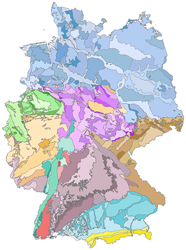
Hydrogeological spatial structure of Germany (HYRAUM)
The hydrogeological spatial structure provides a delimitation of areas with very similar hydrogeological characteristics. These areas, with increasing detail, include large hydrogeological regions, hydrogeological regions and hydrogeological subregions. Each higher level is completely made up of one or more units of the next lower level. In order to compile a digital map of large hydrogeological regions, hydrogeological regions and subregions of Germany, existing regional maps and drafts of the State Geological Surveys have been harmonised and brought together. All in all, the territory of Germany has been subdivided in 10 large hydrogeological regions, in 36 hydrogeological regions and 247 hydrogeological subregions.
INSPIRE
Identification
- File identifier
- b73b55f1-14ec-4b7c-aa59-49b997ce7bbd XML
- Hierarchy level
- Dataset
Online resource
Resource identifier
- code
-
6f4e0e16-9218-4b5d-9f3f-ac6269293e37
- Metadata language
- Deutsch
- Spatial representation type
- Vector
Encoding
- Format
-
Shapefile
- Version
-
n/a
Projection
- code
- EPSG:25832
Classification of data and services
- Topic category
-
- Geoscientific information
Classification of data and services
Coupled resource
Coupled resource
Classification of data and services
Coupled resource
Coupled resource
Keywords
-
GEMET - INSPIRE themes, version 1.0
-
-
Geology
-
Geologie
-
-
GEMET - Concepts, version 2.4
-
-
Hydrogeologie
-
Grundwasser
-
groundwater
-
hydrogeology
-
Other keywords
- Theme
-
-
Hydrogeologische Großräume
-
Hydrogeologische Räume
-
Hydrogeologische Teilräume
-
Large hydrogeological regions
-
Hydrogeological regions
-
Hydrogeological subregions
-
Geographic coverage
))
Temporal reference
Temporal extent
Temporal extent
- Date (Publication)
- 2015-06-01
Quality and validity
- Lineage
-
DE: Erstellt im Rahmen eines Gemeinschaftsprojekts der Staatlichen Geologischen Dienste der Bundesländer (SGD) und der Bundesanstalt für Geowissenschaften und Rohstoffe (BGR). EN: Compiled by the German Federal States Geological Surveys and the Federal Institute for Geosciences and Natural Resources (BGR).
- Denominator
- 500000
Conformity
Conformity
Conformity
Conformity
Conformity
Conformity
- Explanation
-
siehe dazu die angegebene Durchführungsbestimmung
Restrictions on access and use
- Access constraints
- Es gelten keine Zugriffsbeschränkungen
- Access constraints
-
Allgemeine Geschäftsbedingungen, siehe https://www.bgr.bund.de/AGB - General terms and conditions, see https://www.bgr.bund.de/AGB_en . Die bereitgestellten Informationen sind bei Weiterverwendung wie folgt zu zitieren: Datenquelle: HYRAUM v32, (C) BGR & SGD, Hannover, 2015
Responsible organization (s)
Contact for the resource
- Organisation name
-
Bundesanstalt für Geowissenschaften und Rohstoffe (BGR)
Responsible organization (s)
Contact for the resource
- Organisation name
-
Bundesanstalt für Geowissenschaften und Rohstoffe (BGR)
Metadata information
Contact for the metadata
- Organisation name
-
Bundesanstalt für Geowissenschaften und Rohstoffe (BGR)
- Date stamp
- 2023-08-21
- Metadata language
- Deutsch
- Character set
- UTF8
SDS
Conformance class 1: invocable
Access Point URL
Endpoint URL
Technical specification
Conformance class 2: interoperable
Access constraints
Limitation
Use constraints
Limitation
Responsible custodian
Contact for the resource
Overviews
Spatial extent
Provided by
