 www.geodatenkatalog.de (S3F)
Helicopter-borne Electromagnetics (HEM) Area 195 Ahlenmoor
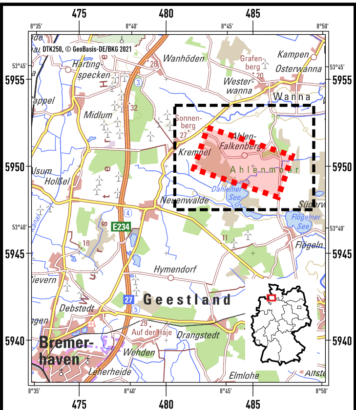
BGR conducted an airborne survey in the region of the Ahlenmoor (Lower Saxony) as part of the BGR project D-AERO-Moore. Cunducting tests of their airborne system, the BGR surveys a portion of the Ahlenmoor with the BGR airborne geophysical standard measuring system. The peatland is located about 15 km northeast of the city of Bremerhaven close to Ahlen-Falkenberg. The size of the area is about 15 km². The area was surveyed with 2 flights totalling to 105 line-km (28,258 survey points). The nominal separation of the 16 WNW-ESE lines and 2 NNE-SSW tie lines was 125 m and 2000 m, respectively. The maps display the geophysical parameters apparent resistivity, apparent depth and centroid depth as well as a data quality parameter derived from the HEM data at the six frequencies of the HEM system (0.4 - 130 kHz). Furthermore, vertical slices were derived from layered-earth models (resistivities and thicknesses of six or twenty model layers) for each flightline and also, based on twenty-layer models, 16 horizontal slices at 0 - 100 m below sea level.
|
|
Citation proposal
(2024) . Helicopter-borne Electromagnetics (HEM) Area 195 Ahlenmoor. https://gdk.gdi-de.org/geonetwork/srv/api/records/b8830188-86fe-44fd-8525-293b53101609 |
Simple
- Alternate title
- 195AhlenmoorHEM
- Date ( Publication )
- 2024-06-01
- Edition
- 1
- Identifier
- fe8b60bd-df64-ce08-89da-9fb875b0bf53
- Identifier
- https://doi.org/10.25928/geas-0z25
- Status
- completed Completed
Point of contact
Bundesanstalt für Geowissenschaften und Rohstoffe (BGR)
-
Siemon, Bernhard, Dr.
Stilleweg 2
Hannover
30655
Deutschland
- GEMET - INSPIRE themes, version 1.0 ( Theme )
-
- Geologie
- Geology
- GEMET - Concepts, version 2.4 ( Theme )
-
- Geophysik
- Keywords ( Theme )
-
- Aerogeophysik
- Hubschrauber-Elektromagnetik
- elektrische Leitfähigkeit
- spezifischer Widerstand
- Halbraumwiderstand
- Schwerpunktstiefe
- airborne geophysics
- helicopter-borne electromagnetics
- electrical conductivity
- resistivity
- apparent resistivity
- centroid depth
- Keywords ( Place )
-
- Niedersachsen
- Ahlenmoor
- Access constraints
- Other restrictions
- Use constraints
- Other restrictions
- Other constraints
- Allgemeine Geschäftsbedingungen, siehe https://www.bgr.bund.de/AGB - General terms and conditions, see https://www.bgr.bund.de/AGB_en. Die bereitgestellten Informationen sind bei Weiterverwendung wie folgt zu zitieren: Datenquelle: 195AhlenmoorHEM, (c) BGR, Hannover, 2024, doi:10.25928/geas-0z25
- Spatial representation type
- Grid
- Metadata language
- German
- Character set
- UTF8
- Topic category
-
- Geoscientific information
N
S
E
W
))
- Distribution format
-
- georef. TIFF (n/a )
- PDF (n/a )
- OnLine resource
-
195AhlenmoorHEM (georef. TIFF)
195AhlenmoorHEM im Format georef. TIFF
- OnLine resource
-
195AhlenmoorHEM (PDF)
195AhlenmoorHEM im Format Adobe Acrobat
- OnLine resource
-
BGR-Website: Projekt D-AERO Moore
BGR-Website: Projekt D-AERO Moore
- OnLine resource
-
Gebietsbericht Archiv-Nr. OASYS 208763
Gebietsbericht Archiv-Nr. OASYS 208763
- OnLine resource
-
Metadatenbeschreibung der Rohdaten
Metadatenbeschreibung der Rohdaten
- Hierarchy level
- Dataset
Conformance result
- Date ( Publication )
- 2010-12-08
- Explanation
- siehe dazu die angegebene Durchführungsbestimmung
- Statement
- BGR-Projekt "D-AERO-Moore: Untersuchung von Möglichkeiten für eine großflächige Moorerkundung"
gmd:MD_Metadata
- File identifier
- b8830188-86fe-44fd-8525-293b53101609 XML
- Metadata language
- German
- Character set
- UTF8
- Parent identifier
- 5d3c332a-bce3-498f-840f-3cbf19359aef
- Hierarchy level
- Dataset
- Hierarchy level name
- Geophysik
- Date stamp
- 2024-06-21
- Metadata standard name
- INSPIRE Metadata Implementing Rules: Technical Guidelines based on EN ISO 19115 and EN ISO 19119
- Metadata standard version
- n/a
Point of contact
Overviews
Provided by

Views
b8830188-86fe-44fd-8525-293b53101609
Access to the portal
Read here the full details and access to the data.
Associated resources
Not available