 www.geodatenkatalog.de (S3L)
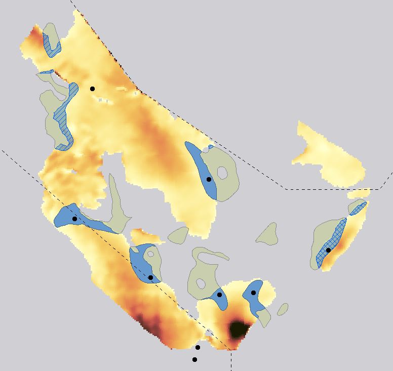
CO2 storage potential of the Jurassic within the German Central Graben
Within the framework of the GEOSTOR Project, the CO2 storage potential of the Jurassic succession in the German Central Graben was analysed. Twelve potential trap structures were initially mapped along the base of the Kimmeridge Clay Formation, which serves as the primary seal for potential reservoir sandstones within the Central Graben Subgroup. The Kimmeridge Clay Formation is generally continuously distributed across the German Central Graben, with only localized penetrations by rising salt diapirs. In contrast, the Central Graben Subgroup, serving as a potential reservoir unit, exhibits an uneven distribution across the area, limiting the presence and continuity of reservoir rocks within each trap structure. To further delineate the spatial extent of the mapped reservoir structures, the base of the Central Graben Subgroup was used as an additional reference layer. Due to the intermittent nature of Jurassic sandstones within the Central Graben Subgroup, a subsequent analysis classified each structure based on borehole data to confirm the presence of reservoir sands. Structures were categorized as ‘proven,’ ‘not present,’ or ‘uncertain’ depending on sandstone availability and continuity within the trap. All mapped reservoir structures are buried at depths ranging from 2225 to 3043 meters (apex depth) and are considered closed systems, situated within a complex structural network of salt diapirs, faults, and pinch-outs. Capacity calculations were conducted following the method outlined by Fuhrmann et al. (2024), and the horizons used for mapping are based on the work of Müller et al. (2023) and Thöle et al. (2021). Fuhrmann, A., Knopf, S., Thöle, H., Kästner, F., Ahlrichs, N., Stück, H.L., Schlieder-Kowitz, A., Kuhlmann, G., (2024). CO2 storage potential of the Middle Buntsandstein Subgroup-German sector of the North Sea. International Journal of Greenhouse Gas Control 136. Müller, S.M., Jähne-Klingberg, F., Thöle, H., Jakobsen, F.C., Bense, F., Winsemann, J. & Gaedicke, C. (2023). Jurassic to Lower Cretaceous tectonostratigraphy of the German Central Graben, southern North Sea. – Netherlands Journal of Geosciences, 102: e4. DOI:10.1017/njg.2023.4 Thöle, H., Jähne-Klingberg, F., Doornenbal, H., den Dulk, M., Britze, P. & Jakobsen F. (2021). Deliverable 3.8 – Harmonized depth models and structural framework of the NL-GER-DK North Sea. GEOERA 3DGEO-EU; 3D Geomodeling for Europe; project number GeoE.171.005. Report.
|
|
Citation proposal
(2024) . CO2 storage potential of the Jurassic within the German Central Graben. https://gdk.gdi-de.org/geonetwork/srv/api/records/b8b91c8e-bf43-477f-8c47-00f1718b76fd |
- Identification
- Distribution
- Quality
- Spatial rep.
- Ref. system
- Content
- Portrayal
- Metadata
- Md. constraints
- Md. maintenance
- Schema info
Identification
Data identification
Citation
- Alternate title
- SpPotJura
- Date ( Publication )
- 2024-09-30
- Identifier
- 9b35cd91-0a1c-c1cb-d82d-24a5f6045a0d
- Status
- completed Completed
Point of contact
- GEMET - INSPIRE themes, version 1.0 ( Theme )
-
- Geology
- Geologie
- Keywords ( Theme )
-
- CO2 storage capacity
- Carbon capture and storage (CCS)
- Jurassic
- German North Sea
- Reservoir evaluation
- Saline aquifers
- opendata
- Keywords ( Place )
-
- EEZ of the German North Sea
Legal constraints
- Access constraints
- Other restrictions
Legal constraints
- Use constraints
- Other restrictions
- Other constraints
- { "id": "dl-by-de/2.0", "name": "Datenlizenz Deutschland Namensnennung 2.0", "url": "https://www.govdata.de/dl-de/by-2-0", "quelle": "GEOSTOR-SpPotJura, BGR, 2024" }
- Spatial representation type
- Vector
- Metadata language
- English
- Character set
- UTF8
- Topic category
-
- Geoscientific information
N
S
E
W
))
Distribution
Distribution
- Distribution format
-
- WMS (OGC:WMS 1.3.0 )
- FileGDB (n/a )
- OnLine resource
-
BGR-Projektseite
BGR-Projektseite
- OnLine resource
-
Geostor-Webseite
Geostor-Webseite
- OnLine resource
-
Geostor-Datenkatalog
Geostor-Datenkatalog
- OnLine resource
-
Daten im Format FileGDB
Daten (FileGDB)
- OnLine resource
-
Karte im BGR-Geoviewer
Karte im BGR-Geoviewer
Quality
Data quality
Scope
- Hierarchy level
- Dataset
- Statement
- Basierend auf seismischen Daten und Bohrungen die entsprechend der Richtlinien des GeolDG frei verfügbar sind.
Metadata
Metadata
- File identifier
- b8b91c8e-bf43-477f-8c47-00f1718b76fd XML
- Metadata language
- English
- Character set
- UTF8
- Parent identifier
- ec1975a4-e9ac-44be-b19f-f6e01ef5177f
- Hierarchy level
- Dataset
- Hierarchy level name
- Geologie
- Date stamp
- 2024-11-21
- Metadata standard name
- INSPIRE Metadata Implementing Rules: Technical Guidelines based on EN ISO 19115 and EN ISO 19119
- Metadata standard version
- n/a
Point of contact
Overviews
Provided by

Views
b8b91c8e-bf43-477f-8c47-00f1718b76fd
Access to the portal
Read here the full details and access to the data.
Associated resources
Not available