 My GeoNetwork catalogue
Processed seismic data of Cruise ARK25/3
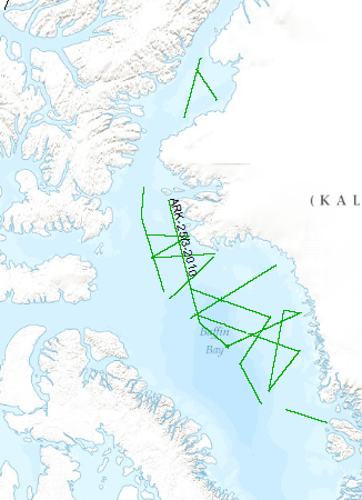
The multidisciplinary marine geoscientific expedition ARK-25/3 was focused on the Greenland part of northern Baffin Bay and was aimed to acquire new geoscientific data to be used for modelling the evolution of the Greenland continental margin and its hydrocarbon prospective. The data format is Society of Exploration Geophysicists SEG Y. The cruise was performed under the direction of the Federal Institute for Geosciences and Natural Resources Hannover in cooperation with the Alfred-Wegener-Institute for Polar and Marine Research, Bremerhaven. Using 70 days of ship time onboard the research icebreaker R/V POLARSTERN a comprehensive data set was acquired along profiles extending from the deep oceanic basin in the central part of North Baffin Bay onto the Greenland continental margin in an area which was bordered by the Kane Basin in the North and Disko Island in the South. By means of multi-channel seismic, wide angle seismic, gravimetric and magnetic methods the structural inventory of the crust in the NW Baffin Bay was investigated. Additionally, heat flow data and sediment cores were collected along lines crossing the Greenland continental margin. The cores were extracted for geochemical and geomicrobiological analysis to be used for basin modelling, studying the hydrocarbon potential, and the hydrocarbon degradation by microorganisms under polar conditions. Geological sampling in the coastal area was done between Melville Bay and Washington Land. The collected rock material will be used to derive constraints on the erosion history of the coastal area. Aeromagnetic data was acquired covering a substantial part of the marine survey area to investigate magnetic signatures of the oceanic crust and the continental margin. This report summarizes the working programme and contains the documentation of acquired data and first results of the expedition.
INSPIRE
Identification
- File identifier
- bc2481a7-bac2-4fab-bb32-9ef26854a04e XML
- Hierarchy level
- Dataset
Online resource
Resource identifier
- code
-
61c769ed-af0a-4875-83bc-6907b23822f6
- Metadata language
- English
- Spatial representation type
- Vector
Encoding
- Format
-
Shapefile
- Version
-
n/a
Projection
- code
- EPSG:4326
Classification of data and services
- Topic category
-
- Geoscientific information
Classification of data and services
Coupled resource
Coupled resource
Classification of data and services
Coupled resource
Coupled resource
Keywords
-
GEMET - INSPIRE themes, version 1.0
-
-
geology
-
Geologie
-
-
GEMET - Concepts, version 2.4
-
-
geophysics
-
Geophysik
-
raw material
-
Rohstoff
-
seismics
-
Seismik
-
Other keywords
- Theme
-
-
marine geology
-
Meeresgeologie
-
two-dimensional seismic reflection
-
zweidimensionale Reflektionsseismik
-
MSSP
-
- Place
-
-
Baffin Bay
-
Baffinbucht
-
Geographic coverage
))
Temporal reference
Temporal extent
Temporal extent
- Date (Creation)
- 2010-09-27
Quality and validity
- Lineage
-
During the period of 1st of August to 9th of October 2010 BGR aquired seismic lines in the Baffin Bay. The lines BGR10-302, BGR10-302A, BGR10-303A, BGR10-305, BGR10-305A, BGR10-306, BGR10-306A, BGR10-307, BGR10-307A, BGR10-308, BGR10-308A, BGR10-309, BGR10-310, BGR10-311, BGR10-312, BGR10-313, BGR10-314, BGR10-315, BGR10-316, BGR10-317, BGR10-318 BGR10-318A, BGR10-319, BGR10-320, BGR10-321, BGR10-322 are processed (migrated) data.
Conformity
Conformity
Conformity
Conformity
Conformity
Conformity
- Explanation
-
siehe dazu die angegebene Durchführungsbestimmung
Restrictions on access and use
- Access constraints
- Es gelten keine Zugriffsbeschränkungen
- Access constraints
-
Allgemeine Geschäftsbedingungen, siehe https://www.bgr.bund.de/AGB - General terms and conditions, see https://www.bgr.bund.de/AGB_en . Die bereitgestellten Informationen sind bei Weiterverwendung wie folgt zu zitieren: Datenquelle: ARK25/3, (c) BGR, Hannover, 2010
Responsible organization (s)
Contact for the resource
- Organisation name
-
Federal Institute for Geosciences and Natural Resources
Responsible organization (s)
Contact for the resource
- Organisation name
-
Federal Institute for Geosciences and Natural Resources
Metadata information
Contact for the metadata
- Organisation name
-
Bundesanstalt für Geowissenschaften und Rohstoffe (BGR)
- Date stamp
- 2025-04-07
- Metadata language
- English
- Character set
- UTF8
SDS
Conformance class 1: invocable
Access Point URL
Endpoint URL
Technical specification
Conformance class 2: interoperable
Access constraints
Limitation
Use constraints
Limitation
Responsible custodian
Contact for the resource
Overviews
Spatial extent
Provided by
