 www.geodatenkatalog.de (S1L)
Starkregen Kalkar hN=90mm
Bei der Starkregenkarte hN=90mm handelt es sich um Simulationsergebnisse, von einem extremen Starkregenereignis mit einer Niederschlagshöhe von 90mm innerhalb von 60 Minuten, im Bereich von Kalkar.
Von Starkregen spricht man wenn, innerhalb kürzester Zeit, große Niederschlagsmengen fallen. Zudem kann langanhaltender Dauerregen, ebenfalls als Starkregen definiert werden.
|
|
Citation proposal
. Starkregen Kalkar hN=90mm. Kreis Kleve - Der Landrat https://gdk.gdi-de.org/geonetwork/srv/api/records/c0854af3-19f9-455c-8d3b-6829244b6bc6 |
INSPIRE
Identification
- File identifier
- c0854af3-19f9-455c-8d3b-6829244b6bc6 XML
- Hierarchy level
- dataset Dataset
Online resource
Resource identifier
- Metadata language
- German
Encoding
Projection
Classification of data and services
- Topic category
-
- Planning cadastre
Classification of data and services
Coupled resource
Coupled resource
Classification of data and services
Coupled resource
Coupled resource
Keywords
- UMTHES Thesaurus ( Theme )
- GEMET - Concepts, version 3.1 ( Theme )
Other keywords
- Keywords
-
- Kreis Kleve
- Kleve
- NW
- NRW
- Nordrhein-Westfalen
- Geoportal
- Klimakarte
- Kalkar
- 051540024024
- opendata
- Keywords ( Theme )
-
- ENVI
- SOCI
Geographic coverage
N
S
E
W
))
Temporal reference
Temporal extent
Temporal extent
- Date ( Creation )
- 2023-05-04T00:00:00.000+02:00
Quality and validity
- Lineage
- Starkregenanalyse
Conformity
Conformity
Conformity
Conformity
Conformity
Conformity
Restrictions on access and use
- Access constraints
- Datenlizenz Deutschland - Zero - Version 2.0 [https://www.govdata.de/dl-de/zero-2-0]
- Access constraints
- {"id":"dl-zero-de/2.0","name":"Datenlizenz Deutschland – Zero – Version 2.0","url":"https://www.govdata.de/dl-de/zero-2-0","quelle":""}
Restrictions on access and use
Responsible organization (s)
Contact for the resource
- Organisation name
- Kreis Kleve - Der Landrat
- info@kreis-kleve.de
- Organisation name
- Kreis Kleve - Abt. Kataster- und Vermessung - Produktbereich GeoInformation (GIS)
Responsible organization (s)
Contact for the resource
- Organisation name
- Kreis Kleve - Der Landrat
- info@kreis-kleve.de
- Organisation name
- Kreis Kleve - Abt. Kataster- und Vermessung - Produktbereich GeoInformation (GIS)
Metadata information
Contact for the metadata
- Organisation name
- Kreis Kleve - Abt. Kataster- und Vermessung - Produktbereich GeoInformation (GIS)
- Date stamp
- 2024-11-21
- Metadata language
- German
SDS
Conformance class 1: invocable
Access Point URL
Endpoint URL
Technical specification
Conformance class 2: interoperable
Coordinate reference system
Quality of Service
Access constraints
Limitation
Use constraints
Limitation
Responsible custodian
Contact for the resource
Conformance class 3: harmonized
Overviews
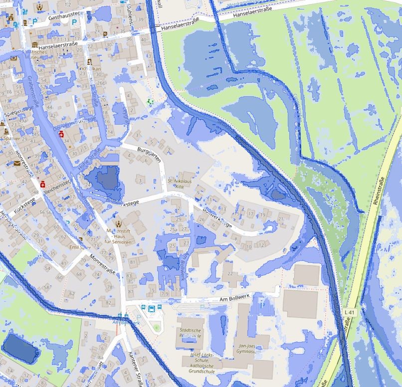
Vorschau Starkregen Kalkar hN=90mm
Provided by

Views
c0854af3-19f9-455c-8d3b-6829244b6bc6
Access to the portal
Read here the full details and access to the data.
Associated resources
Not available