 www.geodatenkatalog.de (S1L)
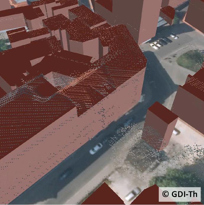
Airborne Laserscanning Daten
Mit dem Airborne Laserscanning Verfahren wird die Erdoberfläche incl. Vegetation, Gebäuden u.a. mittels unregelmäßig verteilten Punkten erfasst. Die Daten werden nach der Erfassung klassifiziert in „Bodenpunkte“ und „Nichtbodenpunkte“. Aus ihnen werden hauptsächlich digitale Geländemodelle sowie digitale Oberflächenmodelle berechnet.
Räumliche Auflösung : 1996-2006 : 4,5 m - 1,5 m; ab 2010 : 0,5 m
|
|
Citation proposal
. Airborne Laserscanning Daten. https://gdk.gdi-de.org/geonetwork/srv/api/records/c8363eb8-7f2a-49b5-bb59-a1571f40a21f |
INSPIRE
Identification
- File identifier
- c8363eb8-7f2a-49b5-bb59-a1571f40a21f XML
- Hierarchy level
- Dataset
Online resource
- Protocol
- WWW:LINK-1.0-http--link
- Protocol
- WWW:LINK-1.0-http--link
Resource identifier
- Metadata language
- German
Encoding
- Format
- LAZ
- Version
- LAS, gezipt
Projection
- code
- EPSG:25832
Classification of data and services
- Topic category
-
- Elevation
- Boundaries
Classification of data and services
Coupled resource
Coupled resource
Classification of data and services
Coupled resource
Coupled resource
Keywords
- GEMET - INSPIRE themes, version 1.0 ( Theme )
-
- Höhe
Other keywords
- Keywords
-
- Geländemodell
- Airborne Laserscanning
- Gelände
- LiDAR
- AdVMIS
- Oberflächenmodell
- Punktwolke
- GOVE
- opendata
- Oberfläche
Geographic coverage
N
S
E
W
))
Temporal reference
Temporal extent
Temporal extent
- Date ( Creation )
- 1996-01-01
Quality and validity
- Lineage
- Die flächendeckende Ersterfassung fand von 1996 bis 2006 mit einer Dichte von 0,05 bis 1,8 Punkten/m² (entspricht einem mittleren Punktabstand von 4,5 m bis 1,5 m) statt. Eine umfassende landesweite Aktualisierung der Laserscanning-Daten erfolgte von 2010 bis 2014 mit einer Erfassungsdichte von 4 Punkten/m² (entspricht einem mittleren Punktabstand von 0,5 m). Seit 2014 erfolgt eine zyklische Fortführung mit den gleichen Parametern.
- Distance
- 0.5 m
Conformity
Conformity
Conformity
Conformity
Conformity
Conformity
Restrictions on access and use
- Access constraints
- Nutzungsbedingungen: Datenlizenz Deutschland-Namensnennung 2.0 in JSON Syntax
- Access constraints
- {"id": "dl-by-de/2.0", "name": "Datenlizenz Deutschland Namensnennung 2.0", "url": "https://www.govdata.de/dl-de/by-2-0 ", "quelle": "© GDI-Th"}
Restrictions on access and use
Responsible organization (s)
Contact for the resource
- Organisation name
- Thüringer Landesamt für Bodenmanagement und Geoinformation
Responsible organization (s)
Contact for the resource
- Organisation name
- Thüringer Landesamt für Bodenmanagement und Geoinformation
Metadata information
Contact for the metadata
- Organisation name
- Thüringer Landesamt für Bodenmanagement und Geoinformation
- Date stamp
- 2024-06-04T12:28:18
- Metadata language
- German
- Character set
- UTF8
SDS
Conformance class 1: invocable
Access Point URL
Endpoint URL
Technical specification
Conformance class 2: interoperable
Coordinate reference system
Quality of Service
Access constraints
Limitation
Use constraints
Limitation
Responsible custodian
Contact for the resource
Conformance class 3: harmonized
Overviews
Provided by

Views
c8363eb8-7f2a-49b5-bb59-a1571f40a21f
Access to the portal
Read here the full details and access to the data.
Associated resources
Not available