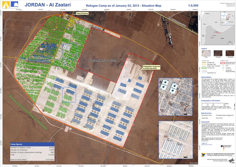
Jordan - Al Zaatari - P02 - Refugee Camp as of January 03, 2013 - Situation Map
The map shows the Al Zaatari refugee camp in Jordan. It is situated approx. 12 km from the Syrian border and in close proximity to the city of Al Mafraq (10 km). The camp was set up on July 28, 2012, to shelter refugees fleeing the conflict in Syria. The map shows general characteristics of the camp infrastructure, including camp extent, location of shelters, containers and facility buildings, road infrastructure and the runway area. For a more detailed view parts of the camp area are also shown in the zoom boxes. The vector data have been digitized on the basis of WorldView-2 satellite data (0.5 m spatial resolution) acquired on January 03, 2013. The results have not been validated in the field. WorldView-2 satellite data acquired on January 03, 2013, is used as backdrop. The products elaborated for this Rapid Mapping Activity are realised to the best of our ability, within a very short time frame, optimising the material available. All geographic information has limitations due to the scale, resolution, date and interpretation of the original source materials. No liability concerning the content or the use thereof is assumed by the producer. The ZKI crisis maps are constantly updated.
|
|
Citation proposal
. Jordan - Al Zaatari - P02 - Refugee Camp as of January 03, 2013 - Situation Map. https://gdk.gdi-de.org/geonetwork/srv/api/records/cd03d5ca-cc33-55d5-85c1-130c5df6ab4c |
Simple
- Date ( Creation )
- 2013-01-08
Point of contact
German Aerospace Center (DLR)
-
ZKI Activation Manager
(Center for Satellite Based Crisis Information (ZKI) )
Muenchner Strasse 20
Wessling
Bavaria
82234
Deutschland
- Maintenance and update frequency
- As needed
- GEMET - INSPIRE themes, version 1.0 ( Theme )
-
- Human health and safety
- ZKI-DE Portfolio according to Annex 1 to the framework contract between BMI und DLR ( Theme )
-
- Humanitarian Crisis
- Keywords ( Place )
-
- Jordan
- Al Zataari
- Keywords
-
- DLR
- EOC
- ZKI
- Use limitation
- Product is optimized for Din A1 printing.
- Use limitation
- The products elaborated for this Rapid Mapping Activity are realised to the best of our ability, within a very short time frame, during a crisis, optimising the material available. All geographic information has limitations due to the scale, resolution, date and interpretation of the original source materials. No liability concerning the content or the use thereof is assumed by the producer.
- Use constraints
- Other restrictions
- Other constraints
- License, use limitations and references (http://s.dlr.de/vz82) according to the framework contract between the German Federal Ministry of the Interior (BMI) and DLR for ZKI products.
- Access constraints
- Other restrictions
- Other constraints
- no limitations on public access
- Denominator
- 5000
- Distance
- 0.5 m
- Metadata language
- English
- Character set
- UTF8
- Topic category
-
- Geoscientific information
N
S
E
W
))
- Reference system identifier
-
http://www.opengis.net/def/crs/EPSG/0/32637
- Date ( Publication )
- 2010-03-31
- Edition
- 7.5
Publisher
- Distribution format
-
- ()
- OnLine resource
-
DLR-ZKI-DE_2013_001_Jordan_Flood_Geographic-Situation-Map_P02_V03_high.jpg
Product in 300dpi resolution
- OnLine resource
-
DLR-ZKI-DE_2013_001_Jordan_Flood_Geographic-Situation-Map_P02_V03_med.jpg
Product in 150dpi resolution
- OnLine resource
-
DLR-ZKI-DE_2013_001_Jordan_Flood_Geographic-Situation-Map_P02_V03_low.jpg
Product in 100dpi resolution
- OnLine resource
-
DLR-ZKI-DE_2013_001_Jordan_Flood_Geographic-Situation-Map_P02_V03.pdf
GeoPDF Product
- OnLine resource
-
DLR-ZKI-DE_2013_001_Jordan_Flood_Geographic-Situation-Map_P02_V03.kmz
Product as KMZ in 100dpi resolution
- Hierarchy level
- Dataset
- Statement
- Statement of conformity: The Center for Satellite Based Crisis Information (ZKI) produced this product by satellite analyses in the context of the framework contract between BMI and DLR. Quality Disclaimer: This product is a standard product in line with the ZKI portfolio and/or with the mapping guidelines current at time of production. Data sources: WorldView-2 © European Space Imaging 2013
- Description
- Vector data creation by manual interpretation and digitization of WorldView-2 data of January 03, 2013
- Description
- Map compilation and cartographical enhancement
- Description
- Product generation using ArcGIS 10.1, SP1, ZKI Export Tool 0.1
gmd:MD_Metadata
- File identifier
- cd03d5ca-cc33-55d5-85c1-130c5df6ab4c XML
- Metadata language
- English
- Character set
- UTF8
- Hierarchy level
- Dataset
- Date stamp
- 2024-06-20T13:12:44
- Metadata standard name
- ISO 19115:2003/19139
- Metadata standard version
- 1.0
Point of contact
German Aerospace Center (DLR)
-
ZKI Activation Manager
(Center for Satellite Based Crisis Information (ZKI) )
Muenchner Strasse 20
Wessling
Bavaria
82234
Deutschland
Overviews

thumbnail

large_thumbnail
Provided by

Views
cd03d5ca-cc33-55d5-85c1-130c5df6ab4c
Access to the portal
Read here the full details and access to the data.
Associated resources
Not available
 www.geodatenkatalog.de (S3L)