 www.geodatenkatalog.de (S2F)
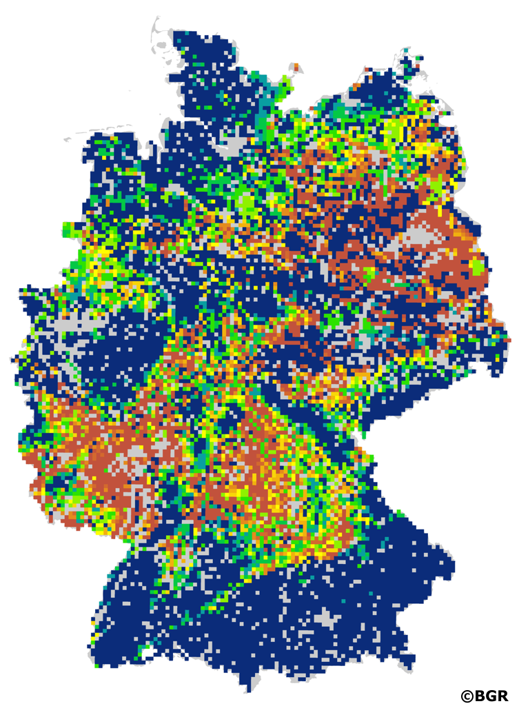
Effective water balance during the main vegetation period (May-August) in Germany based on climate scenario data
The effective water balance is the difference between water supply and potential evapotranspiration during the main vegetation period (May-August). The water supply consists of the precipitation during this period, the amount of water present in the soil (described by the usable field capacity in the effective rooting zone) and possibly a capillary rise. The capillary rise is the result of the ascent rate per day and the culture-dependent duration of the ascent. The rate of ascent depends essentially on the soil texture and the distance of the lower limit of the effective rooting zone to the groundwater or backwater body. The landuse stratified soil map of Germany at scale 1:1,000,000 (BUEK1000N) was used as pedological input to the model. The landuse information was derived from CORINE land cover data set (CLC2006). The climate scenario data (https://www.dwd.de/ref-ensemble) was provided by the German Meteorological Service (DWD) in a resolution of 5 x 5 km. It contains 16 bias-corrected datasets (combination of global and regional climate models), which describe the scenario RCP8.5 (RCPs Representative Concentration Pathways) assuming an additional radiation of 8,5 W/m². The nine raster datasets with a resolution of 5 x 5 km represent the mean, the 15th and 85th percentile of the effective water balance during the main vegetation period in Germany for the climate periods 1971-2000, 2031-2060 and 2071-2099.
|
|
Citation proposal
(2020) . Effective water balance during the main vegetation period (May-August) in Germany based on climate scenario data. https://gdk.gdi-de.org/geonetwork/srv/api/records/cde3fff9-70fd-49eb-b0af-db456e1069d2 |
INSPIRE
Identification
- File identifier
- cde3fff9-70fd-49eb-b0af-db456e1069d2 XML
- Hierarchy level
- dataset Dataset
Online resource
Resource identifier
- code
- ee5fbb78-e8ac-f5fa-b256-f612614aa2fe
- Metadata language
- ger German
- Spatial representation type
- Grid
Encoding
- Format
- GeoTIFF
- Version
- n/a
Projection
Classification of data and services
- Topic category
-
- Geoscientific information
Classification of data and services
Coupled resource
Coupled resource
Classification of data and services
Coupled resource
Coupled resource
Keywords
- GEMET - INSPIRE themes, version 1.0 ( Theme )
-
- Soil
- Boden
- Spatial scope
-
- National
- GEMET - Concepts, version 4.1.3 ( Theme )
-
- Klimaentwicklung
- Klimaänderung
- Folgen des Klimawandels
- Evapotranspiration
- Versickerung
- Wasserbilanz
- Bodenwasserhaushalt
- SGD-Liste ( Theme )
-
- Klima
- pflanzenverfügbares Bodenwasser
- Freies Schlagwort ( Theme )
-
- Klimaszenario
- Klimamodellierung
- opendata
Other keywords
- Keywords ( Place )
-
- Deutschland
Geographic coverage
N
S
E
W
))
Temporal reference
Temporal extent
Temporal extent
- Date ( Publication )
- 2020-01-14
Quality and validity
- Lineage
- BÜK1000N der BGR, CORINE Land Cover (CLC2006), Klimaszenariendaten des DWD für das Scenario RCP8.5.
- Denominator
- 5000000
Conformity
Conformity
Conformity
Conformity
Conformity
Conformity
- Explanation
- siehe dazu die angegebene Durchführungsbestimmung
Restrictions on access and use
- Access constraints
- Allgemeine Geschäftsbedingungen, siehe https://www.bgr.bund.de/AGB - General terms and conditions, see https://www.bgr.bund.de/AGB_en. Die bereitgestellten Informationen sind bei Weiterverwendung wie folgt zu zitieren: Datenquelle: WB5000_RCP85, (C) BGR, Hannover, 2020
- Access constraints
- Dieser Datensatz kann gemäß der "Nutzungsbestimmungen für die Bereitstellung von Geodaten des Bundes" (https://sg.geodatenzentrum.de/web_public/gdz/lizenz/geonutzv.pdf) genutzt werden.
- Access constraints
- {"id": "geoNutz/20130319", "name": "Nutzungsbestimmungen für die Bereitstellung von Geodaten des Bundes", "url": "https://sg.geodatenzentrum.de/web_public/gdz/lizenz/geonutzv.pdf", "quelle": "WB5000_RCP85, (C) BGR, Hannover, 2020"}
Restrictions on access and use
Responsible organization (s)
Contact for the resource
- Organisation name
- Bundesanstalt für Geowissenschaften und Rohstoffe
- fis.bo@BGR.de
Responsible organization (s)
Contact for the resource
- Organisation name
- Bundesanstalt für Geowissenschaften und Rohstoffe
- fis.bo@BGR.de
Metadata information
Contact for the metadata
- Organisation name
- Bundesanstalt für Geowissenschaften und Rohstoffe (BGR)
- Date stamp
- 2023-08-22
- Metadata language
- German
- Character set
- utf8 UTF8
SDS
Conformance class 1: invocable
Access Point URL
Endpoint URL
Technical specification
Conformance class 2: interoperable
Coordinate reference system
Quality of Service
Access constraints
Limitation
Use constraints
Limitation
Responsible custodian
Contact for the resource
Conformance class 3: harmonized
Overviews
Provided by

Views
cde3fff9-70fd-49eb-b0af-db456e1069d2
Access to the portal
Read here the full details and access to the data.
Associated resources
Not available