 www.geodatenkatalog.de (S3L)
Three-dimensional hydrochemical data of Lake Runstedt (Germany) for three campaigns in 2023
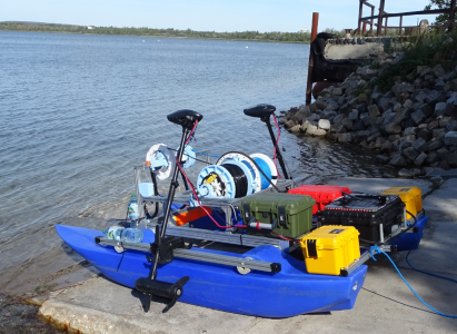
Lake Runstedt, around 30 km west of Leipzig, is a post-mining lake created by the flooding of the former Großkayna open-cast mine. After the end of the lignite mining, the pit was partially filled with industrial waste and fly ash for several decades. With high concentrations of ammonium in the sediment, oxygen consumption due to nitrification of ammonium released into the lake is a major challenge to the lake’s water quality. To ensure the oxygen supply in the hypolimnion (i.e. the bottom lake layer that is not affected by wind mixing) in summer, three aerators are operated in the lake by the Lausitzer und Mitteldeutsche Bergbau-Verwaltungsgesellschaft (LMBV). In 2023, the Freiberg University of Mining and Technology was commissioned by the BGR to carry out three measurement campaigns (end of July/beginning of August, mid-September, mid-October) on the lake using an autonomous surface vehicle (here: a catamaran-shaped robotic device) to assess the spatial effects of the aeration on lake water quality. The data set provided contains the collected three-dimensional data of water temperature, oxygen content, pH, electrical conductivity, turbidity and chlorophyll. In addition, laboratory analyses of water samples obtained with a Ruttner sampler are included. The data reflect the conditions before and after operation of the aerators. Detailed explanations can be found in the publication “Spatial heterogeneity of dissolved oxygen and sediment fluxes revealed by autonomous robotic lakewater profiling” (2025) by Röder et al. in the journal Limnology and Oceanography (http://doi.org/10.1002/lno.70174).
|
|
Citation proposal
(2025) . Three-dimensional hydrochemical data of Lake Runstedt (Germany) for three campaigns in 2023. https://gdk.gdi-de.org/geonetwork/srv/api/records/cfad249e-f284-4f9c-818e-605b9206948f |
INSPIRE
Identification
- File identifier
- cfad249e-f284-4f9c-818e-605b9206948f XML
- Hierarchy level
- dataset Dataset
Online resource
Resource identifier
- Metadata language
- ger English
- Spatial representation type
- Text, table
Encoding
- Format
- csv
- Version
- n/a
- Format
- r
- Version
- n/a
Projection
Classification of data and services
- Topic category
-
- Environment
Classification of data and services
Coupled resource
Coupled resource
Classification of data and services
Coupled resource
Coupled resource
Keywords
Other keywords
- Keywords ( Theme )
-
- monitoring
- oxygen
- pit lake
- aeration
- water quality
- autonomous surface vehicle
- opendata
- Monitoring
- Sauerstoff
- Bergbaufolgesee
- Belüftung
- Wasserqualität
- Schwimmroboter
- Keywords ( Place )
-
- Lake Runstedt
- Saxony-Anhalt
- Germany
Geographic coverage
N
S
E
W
))
Temporal reference
Temporal extent
Temporal extent
- Date ( Publication )
- 2025-07-25
Quality and validity
- Lineage
- Multiparameter profile data obtained with an unmanned autonomous surface vehicle (ASV) gathered by Freiberg University of Mining and Technology commissioned by the Federal Institute of Geosciences and Natural Resources (BGR); Methodological information in Röder, E. et al. (2025): Spatial heterogeneity of dissolved oxygen and sediment fluxes revealed by autonomous robotic lakewater profiling. Limnology and Oceanography. (http://doi.org/10.1002/lno.70174) Monitoring data (oygen and temperature profiles, ion analysis for several dates) provided by Lausitz and Central German Mining Administration Company (LMBV); Water analysis data during ASV campaign gathered by Federal Institute of Geosciences and Natural Resources (BGR); Wind data retrieved from website of the German Weather Service (Deutscher Wetterdienst - DWD)
Conformity
Conformity
Conformity
Conformity
Conformity
Conformity
Restrictions on access and use
- Access constraints
- For data contained in folder "Entire data set" Creative Commons BY 4.0 - Licence "CC BY 4.0" applies Source acknowledgement: Federal Institute for Geosciences and Natural Resources (BGR) and Freiberg University of Mining and Technology (TUBAF)
- Access constraints
- {"id": "cc-by/4.0", "name": "Creative Commons Namensnennung – 4.0 International (CC BY 4.0)", "url": "http://creativecommons.org/licenses/by/4.0/", "quelle": "Federal Institute for Geosciences and Natural Resources (BGR) and Freiberg University of Mining and Technology (TUBAF)"}
- Access constraints
- For supplementary data contained in folder "Data for Publication Roeder et al. 2025" - Monitoring data of Lausitzer und Mitteldeutsche Bergbau-Verwaltungsgesellschaft (LMBV): can only be used after explicit approval by LMBV. To obtain approval, please email to info@lmbv.de.
- Access constraints
- {"id": "other-closed", "name": "Andere geschlossene Lizenz", "url": "", "quelle": "Monitoring data of Lausitzer und Mitteldeutsche Bergbau-Verwaltungsgesellschaft (LMBV): can only be used after explicit approval by LMBV. To obtain approval, please email to info@lmbv.de"}
- Access constraints
- Wind data of the German Weather Service (DWD): Creative Commons BY 4.0 - Licence "CC BY 4.0" applies (https://opendata.dwd.de/climate_environment/CDC/Terms_of_use.pdf) Data was downloaded from https://opendata.dwd.de/
- Access constraints
- {"id": "cc-by/4.0", "name": "Creative Commons Namensnennung – 4.0 International (CC BY 4.0)", "url": "https://opendata.dwd.de/climate_environment/CDC/Terms_of_use.pdf", "quelle": "https://opendata.dwd.de/"}
Restrictions on access and use
Responsible organization (s)
Contact for the resource
- Organisation name
- Bundesanstalt für Geowissenschaften und Rohstoffe (BGR)
- Postfach-B25@bgr.de
Responsible organization (s)
Contact for the resource
- Organisation name
- Bundesanstalt für Geowissenschaften und Rohstoffe (BGR)
- Postfach-B25@bgr.de
Metadata information
Contact for the metadata
- Organisation name
- Bundesanstalt für Geowissenschaften und Rohstoffe (BGR)
- Date stamp
- 2025-08-15
- Metadata language
- English
- Character set
- utf8 UTF8
SDS
Conformance class 1: invocable
Access Point URL
Endpoint URL
Technical specification
Conformance class 2: interoperable
Coordinate reference system
Quality of Service
Access constraints
Limitation
Use constraints
Limitation
Responsible custodian
Contact for the resource
Conformance class 3: harmonized
Overviews
Provided by

Views
cfad249e-f284-4f9c-818e-605b9206948f
Access to the portal
Read here the full details and access to the data.
Associated resources
Not available