 www.geodatenkatalog.de (S1L)
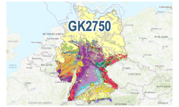
Geological Map of Germany 1:2,750,000 (GK2750)
The digital GK2750 Geology represents the surface geology of Germany at a scale of 1:2,750,000. The map comprises 28 units differentiated according to their age of formation. It also contains information on the distribution of volcanic and plutonic rocks. Furthermore, the map shows tectonic line elements, marginal positions of the ice shield of the last glacial periods and the impact formation Nördlinger Ries.
|
|
Citation proposal
(2022) . Geological Map of Germany 1:2,750,000 (GK2750). https://gdk.gdi-de.org/geonetwork/srv/api/records/d0d389b9-78ca-409b-a357-c23212b22d7f |
- Identification
- Distribution
- Quality
- Spatial rep.
- Ref. system
- Content
- Portrayal
- Metadata
- Md. constraints
- Md. maintenance
- Schema info
Identification
Data identification
Citation
- Alternate title
- GK2750
- Date ( Publication )
- 2022-11-11
- Identifier
- 25c294f8-ec6e-66c7-d1cf-39211af95b9f
- Status
- completed Completed
Point of contact
Bundesanstalt für Geowissenschaften und Rohstoffe
-
Wiechmann, Marc Filip, Dr.
Stilleweg 2
Hannover
30655
DE
- GEMET - INSPIRE themes, version 1.0 ( Theme )
-
- Geologie
- Geology
- GEMET - Concepts, version 2.4 ( Theme )
-
- tectonic
- Tektonik
- Keywords ( Theme )
-
- Eisrandlagen
- Genese
- Oberflächengeologie
- Petrographie
- Stratigraphie
- opendata
- Keywords ( Place )
-
- Deutschland
- High-value dataset categories
-
- Erdbeobachtung und Umwelt
Legal constraints
- Access constraints
- Other restrictions
Legal constraints
- Use constraints
- Other restrictions
- Other constraints
- Allgemeine Geschäftsbedingungen, s. https://www.bgr.bund.de/agb - General Terms and Conditions, s. https://www.bgr.bund.de/agb_en
- Other constraints
- Dieser Datensatz kann gemäß der "Nutzungsbestimmungen für die Bereitstellung von Geodaten des Bundes" (https://sg.geodatenzentrum.de/web_public/gdz/lizenz/geonutzv.pdf) genutzt werden.
- Other constraints
- {"id": "geoNutz/20130319", "name": "Nutzungsbestimmungen für die Bereitstellung von Geodaten des Bundes", "url": "https://sg.geodatenzentrum.de/web_public/gdz/lizenz/geonutzv.pdf", "quelle": "Bundesanstalt für Geowissenschaften und Rohstoffe (BGR)"}
- Spatial representation type
- Grid
- Denominator
- 2750000
- Metadata language
- ger German
- Character set
- utf8 UTF8
- Topic category
-
- Geoscientific information
N
S
E
W
))
- Geographic identifier
- 000000000000
Distribution
Distribution
- Distribution format
-
- Shapefile (n/a )
Digital transfer options
- Transfer size
- 3
- OnLine resource
-
GK2750 (Shapefile)
GK2750 im Format ESRI Shape
Quality
Data quality
Scope
- Hierarchy level
- Dataset
Conformance result
Citation
- Date ( Publication )
- 2010-12-08
- Explanation
- siehe dazu die angegebene Durchführungsbestimmung
- Statement
- keine Angabe
Metadata
Metadata
- File identifier
- d0d389b9-78ca-409b-a357-c23212b22d7f XML
- Metadata language
- German
- Character set
- utf8 UTF8
- Hierarchy level
- dataset Dataset
- Hierarchy level name
- Geologie
- Date stamp
- 2024-04-26
- Metadata standard name
- INSPIRE Metadata Implementing Rules: Technical Guidelines based on EN ISO 19115 and EN ISO 19119
- Metadata standard version
- n/a
Point of contact
Overviews
Provided by

Views
d0d389b9-78ca-409b-a357-c23212b22d7f
Access to the portal
Read here the full details and access to the data.
Associated resources
Not available