 www.geodatenkatalog.de (S3L)
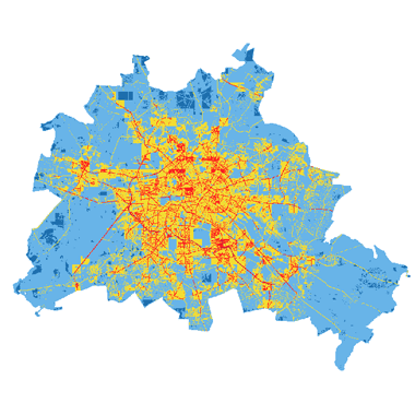
Durchschnittliche jährliche Luftschadstoffbelastung: Modelldaten (Umweltatlas)
Die Karte enthält die modellierten Luftschadstoffe NO2, PM10 und PM2.5 ausgegeben als Jahresmittelwert in µg/m3 auf einem 50 x 50 Quadratmeter Raster im Berliner Stadtgebiet.
|
|
Citation proposal
(2025) . Durchschnittliche jährliche Luftschadstoffbelastung: Modelldaten (Umweltatlas). https://gdk.gdi-de.org/geonetwork/srv/api/records/d38aed69-fc15-34f5-89ca-55dab49266af |
Simple
Identification info
- Date ( Creation )
- 2024-12-31
- Date ( Publication )
- 2025-06-13
- Date ( Revision )
- 2025-06-13
- Presentation form
- Digital map
Point of contact
Point of contact
- Maintenance and update frequency
- Not planned
- Keywords ( Theme )
-
- open data
- opendata
- Sachdaten
- Karten
- Geodaten
- Berlin
- Umweltatlas
- Luft
- Luftqualität
- Luftschadstoffe
- Luftbelastung
- Schadstoffe
- Luftreinhaltung
- Luftreinhalteplan
- Luftreinhalteplanung
- Luftverschmutzung
- Räumlicher Anwendungsbereich ( Theme )
- Keywords
-
- infoMapAccessService
- Access constraints
- Other restrictions
- Use constraints
- Other restrictions
- Other constraints
- Für die Nutzung der Daten ist die Datenlizenz Deutschland - Zero - Version 2.0 anzuwenden. Die Lizenz ist über https://www.govdata.de/dl-de/zero-2-0 abrufbar.
- Other constraints
- {"id":"dl-zero-de/2.0","name":"Datenlizenz Deutschland - Zero - Version 2.0","url":"https://www.govdata.de/dl-de/zero-2-0"}
- Service Type
- view
- Service Version
- OGC:WMS 1.0.0
- Service Version
- OGC:WMS 1.1.0
- Service Version
- OGC:WMS 1.1.1
- Service Version
- OGC:WMS 1.3.0
N
S
E
W
))
- Extent type code
- true
- Geographic identifier
- 110000000000
- Coupling Type
- Tight
Contains Operations
- Operation Name
- GetCapabilities
- Distributed Computing Platforms
- Web services
- Operates On
- Reference system identifier
- http://www.opengis.net/def/crs/EPSG/0/25833
- Distribution format
-
-
Text/HTML
(4.01 )
- Specification
- Keine Angabe
-
Text/HTML
(4.01 )
- OnLine resource
-
Darstellungsdienst - Durchschnittliche jährliche Luftschadstoffbelastung: Modelldaten (Umweltatlas) (WMS)
Darstellungsdienst - Durchschnittliche jährliche Luftschadstoffbelastung: Modelldaten (Umweltatlas) (WMS)
- OnLine resource
-
Darstellung der Karte im Geoportal Berlin
Darstellung der Karte im Geoportal Berlin
- Hierarchy level
- Service
- Other
- Dienst
gmd:MD_Metadata
- File identifier
- d38aed69-fc15-34f5-89ca-55dab49266af XML
- Metadata language
- German
- Character set
- UTF8
- Hierarchy level
- Service
- Hierarchy level name
- Durchschnittliche jährliche Luftschadstoffbelastung: Modelldaten (Umweltatlas) Dienst
- Date stamp
- 2025-11-19T00:00:00Z
- Metadata standard name
- ISO 19115/19119 - BE
- Metadata standard version
- 1.0.0
Point of contact
Overviews
Vorschaubild
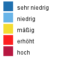
Legende
Provided by

Views
d38aed69-fc15-34f5-89ca-55dab49266af
Access to the portal
Read here the full details and access to the data.
Associated resources
Not available