 www.geodatenkatalog.de (S2F)
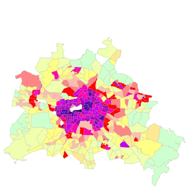
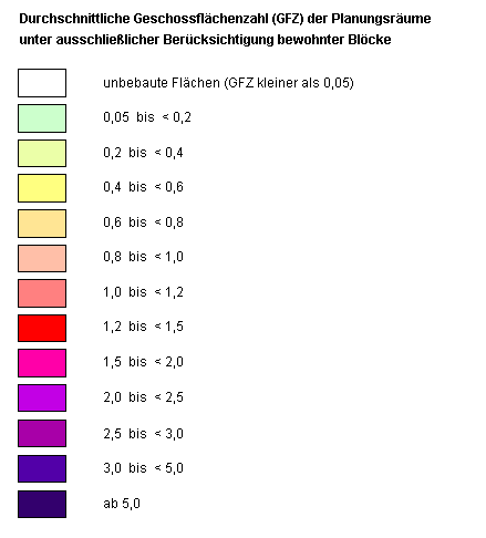
Städtebauliche Dichte - Geschossflächenzahl (GFZ) 2008 (PLR)
Darstellung der real vorhandenen GFZ als Maß der städtebaulichen Dichte für PLR (Planungsräume). Die GFZ gibt mit dem Verhältnis der Summe der Geschossflächen zur Blockfläche die Nutzungsintensität von Bauflächen an.
|
|
Citation proposal
(2009) . Städtebauliche Dichte - Geschossflächenzahl (GFZ) 2008 (PLR). https://gdk.gdi-de.org/geonetwork/srv/api/records/d3d79db4-ab87-38cb-8aa3-d11bc606aa6d |
- Identification
- Distribution
- Quality
- Spatial rep.
- Ref. system
- Content
- Portrayal
- Metadata
- Md. constraints
- Md. maintenance
- Schema info
Identification
Identification info
Service Identification (19119)
Citation
- Date ( Creation )
- 2009-11-30
- Date ( Publication )
- 2009-12-01
- Presentation form
- Digital map
Point of contact
Point of contact
- Keywords ( Theme )
-
- open data
- opendata
- Karten
- Geodaten
- Berlin
- LOR
- Planungsräume
- Lebensweltlich orientierte Räume
- Nutzungsdichte
- Umweltatlas
- Städtebauliche Dichte
- Geschossflächenzahl
- GFZ
Legal constraints
- Access constraints
- Other restrictions
Legal constraints
- Use constraints
- Other restrictions
- Other constraints
- Für die Nutzung der Daten ist die Datenlizenz Deutschland - Zero - Version 2.0 anzuwenden. Die Lizenz ist über https://www.govdata.de/dl-de/zero-2-0 abrufbar.
- Other constraints
- { "id": "dl-zero-de/2.0" , "name": "Datenlizenz Deutschland - Zero - Version 2.0", "url": "https://www.govdata.de/dl-de/zero-2-0" }
- Service Type
- view
- Service Version
- OGC:WMS 1.0.0
- Service Version
- OGC:WMS 1.1.0
- Service Version
- OGC:WMS 1.1.1
- Service Version
- OGC:WMS 1.3.0
Extent
N
S
E
W
))
Geographic description
- Extent type code
- true
- Geographic identifier
- 110000000000
- Coupling Type
- Tight
Contains Operations
- Operation Name
- GetCapabilities
- Distributed Computing Platforms
- Web services
Distribution
Distribution
- Distribution format
-
- Text/HTML (4.01 )
Digital transfer options
- OnLine resource
-
GetCapabilities Aufruf des WMS mit maschinenlesbarer Antwort
GetCapabilities Aufruf des WMS mit maschinenlesbarer Antwort
- OnLine resource
-
Aufruf des Geoportals Berlin mit Darstellung der Karte und weiterer Metadaten
Aufruf des Geoportals Berlin mit Darstellung der Karte und weiterer Metadaten
- OnLine resource
-
Inhaltliche Beschreibung
Inhaltliche Beschreibung
Quality
Scope
- Hierarchy level
- Service
- Other
- Dienst
Ref. system
- Reference system identifier
- http://www.opengis.net/def/crs/EPSG/0/3068
Metadata
Metadata
- File identifier
- d3d79db4-ab87-38cb-8aa3-d11bc606aa6d XML
- Metadata language
- German
- Character set
- UTF8
- Hierarchy level
- Service
- Hierarchy level name
- Städtebauliche Dichte - Geschossflächenzahl (GFZ) 2008 (PLR) Dienst
- Date stamp
- 2025-03-06T12:25:49
- Metadata standard name
- ISO 19115/19119 – BE
- Metadata standard version
- 1.0.0
Overviews
Vorschaugrafik
Legende
Provided by

Views
d3d79db4-ab87-38cb-8aa3-d11bc606aa6d
Access to the portal
Read here the full details and access to the data.
Associated resources
Not available