 www.geodatenkatalog.de (S1L)
Processed seismic data of Cruise BGR87
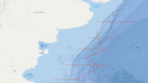
In the period from 22nd December, 1987 to 15th January, 1988 a geophysical reconnaissance survey has been carried out with S.V. EXPLORA on the Argentine Eastern continental margin. A total of 3,675 km of digital seismic reflection profiles in parallel with gravimetric and in part magnetic measurements, and 13 sonobuoy refraction profiles were recorded during this survey. The general aim of the survey was to search the Argentine eastern continental margin between 37°S and 47°S for evidence of continent-ocean boundary structures previously recognized by us off South Africa. The following preliminary results were obtained: (1) Five regional seismic markers/unconformities have been observed, named from bottom to top AR V to AR I. (2) Two units are recognizable on all reflection seismic records: A buried lower unit the top of which is marked by the distinct 'AR IV' unconformity of presumably Beriasian/Valangian age, and a tectonically undisturbed upper sedimentary unit. (3) The dominant feature of the lower unit is a 50 km to 100 km broad wedge-shaped body characterized by an internally divergent pattern of reflection horizons having seaward dip. The seismic characteristics and recent ODP drilling is consistent with the wedge being formed from extrusive basaltic rocks. (4) The more than 5000 m thick wedge is parallel with the shelf edge and can be traced continuously for 1200 km. Its landward pinchout coincides with the magnetic slope anomaly 'G'. (5) A giant contourite mound of Neogene age has been recognized in the southeastern part of the survey area. (6) Bottom simulating reflectors have been recognized. Their occurrence is associated with the contourite mound.
|
|
Citation proposal
. Processed seismic data of Cruise BGR87. https://gdk.gdi-de.org/geonetwork/srv/api/records/d4143f84-fdcf-4c70-96f2-7da4be099bc9 |
- Identification
- Distribution
- Quality
- Spatial rep.
- Ref. system
- Content
- Portrayal
- Metadata
- Md. constraints
- Md. maintenance
- Schema info
Identification
Data identification
Citation
- Alternate title
- BGR87 1987
- Date ( Creation )
- 1988-01-15
- Identifier
- 7f2368a2-56f9-e95e-5b6b-3201b93ade13
- Status
- completed Completed
Point of contact
- GEMET - INSPIRE themes, version 1.0 ( Theme )
-
- Geologie
- geology
- GEMET - Concepts, version 2.4 ( Theme )
-
- geophysics
- Geophysik
- raw material
- Rohstoff
- Keywords ( Theme )
-
- Marine geology
- Meeresgeologie
- Seismics
- Seismik
- Two-dimensional seismic reflection
- zweidimensionale Reflektionsseismik
- Keywords ( Place )
-
- Southwest Atlantic Ocean
- Südwest-Atlantik
- Argentinien
- Argentina
Legal constraints
- Access constraints
- Other restrictions
Legal constraints
- Use constraints
- Other restrictions
- Other constraints
- Allgemeine Geschäftsbedingungen, siehe http://www.bgr.bund.de/AGB - General terms and conditions, see http://www.bgr.bund.de/AGB_en. Die bereitgestellten Informationen sind bei Weiterverwendung wie folgt zu zitieren: Datenquelle: BGR87 1987, (c) BGR, Hannover, 2018
- Spatial representation type
- Vector
- Metadata language
- English
- Character set
- UTF8
- Topic category
-
- Geoscientific information
N
S
E
W
))
Distribution
Distribution
- Distribution format
-
- Shapefile (n/a )
Digital transfer options
- Transfer size
- 2
- OnLine resource
-
BGR87 1987 (Shapefile)
BGR87 1987 im Format ESRI Shape
- OnLine resource
-
Profile BGR87-01
Profile BGR87-01
- OnLine resource
-
Profile BGR87-02
Profile BGR87-02
- OnLine resource
-
Profile BGR87-03
Profile BGR87-03
- OnLine resource
-
Profile BGR87-04
Profile BGR87-04
- OnLine resource
-
Profile BGR87-05
Profile BGR87-05
- OnLine resource
-
Profile BGR87-06
Profile BGR87-06
- OnLine resource
-
Profile BGR87-07
Profile BGR87-07
- OnLine resource
-
Profile BGR87-08
Profile BGR87-08
- OnLine resource
-
Profile BGR87-09
Profile BGR87-09
- OnLine resource
-
Karte im BGR-Geoviewer
Karte im BGR-Geoviewer
Quality
Data quality
Scope
- Hierarchy level
- Dataset
Conformance result
Citation
- Date ( Publication )
- 2010-12-08
- Explanation
- siehe dazu die angegebene Durchführungsbestimmung
- Statement
- During the period from 22th December 1987 to 20th January 1988 BGR acquired seismic lines off the Atlantic coast of South America. The lines BGR87-01 to BGR87-09 are migrated data.
Metadata
Metadata
- File identifier
- d4143f84-fdcf-4c70-96f2-7da4be099bc9 XML
- Metadata language
- English
- Character set
- UTF8
- Parent identifier
- 06a73c56-06a2-40d8-b806-466222b0760d
- Hierarchy level
- Dataset
- Hierarchy level name
- Geophysik
- Date stamp
- 2023-11-16
- Metadata standard name
- INSPIRE Metadata Implementing Rules: Technical Guidelines based on EN ISO 19115 and EN ISO 19119
- Metadata standard version
- n/a
Point of contact
Overviews
Provided by

Views
d4143f84-fdcf-4c70-96f2-7da4be099bc9
Access to the portal
Read here the full details and access to the data.
Associated resources
Not available