 My GeoNetwork catalogue
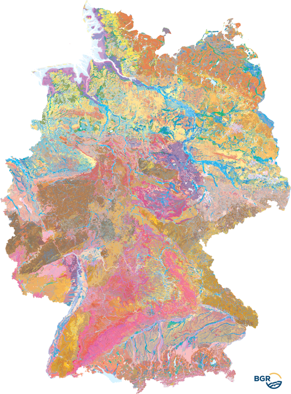
Soil map of Germany 1:250,000
The Soil Map 1:250,000 (BUEK250), the digital successor to the Soil Map 1:200,000 (BUEK200), provides a detailed, nationwide standardized and comprehensive information basis for cross-state statements on soil use and soil protection in Germany. The present graphic dataset, version 6.0, is essentially based on the BUEK200, which was developed by the Federal Institute for Geosciences and Natural Resources (BGR) in cooperation with the State Geological Surveys (SGD) of the federal states. It is graphically free of sheet sections and describes the distribution and association of soils on the basis of a total of 2171 legend units. The detailed pedological information is stored separately in a relational database and can be linked to the BUEK250 graphic dataset via the GEN_ID data field.
Simple
- Alternate title
-
BÜK250
- Date (Publication)
- 2024-09-03
- Edition
-
6.0 mit Gewässerflächen
- Citation identifier
- 1024DAC8-ACE7-4509-ACB2-C513961F42D2
- Citation identifier
- https://doi.org/10.25928/BUEK250_6.0
- Other citation details
-
BGR (2024): Bodenübersichtskarte der Bundesrepublik Deutschland 1:250.000 (BÜK250), Hannover, DOI:10.25928/BUEK250_6.0
- Status
- Completed
-
GEMET - INSPIRE themes, version 1.0
-
-
Boden
-
Soil
-
-
GEMET - Concepts, version 2.4
-
-
Bodenfeuchtigkeit
-
Bodenart
-
Bodenkarte
-
Bodenfunktion
-
Bodenbelastung
-
Bodenfruchtbarkeit
-
Bodennutzung
-
Bodenverbreitung
-
Bodenhorizont
-
Bodeneigenschaften
-
-
Freies Schlagwort
-
-
Bodengesellschaft
-
Bodensubstrat
-
Bodenprofil
-
Bodentyp
-
Bodenform
-
Bodensystematik
-
Bodenausgangsgestein
-
- Place
-
-
Bundesrepublik Deutschland
-
- Keywords
-
-
opendata
-
inspireidentifiziert
-
-
High-value dataset categories
-
-
Erdbeobachtung und Umwelt
-
-
Spatial scope
-
-
National
-
- Access constraints
- Other restrictions
- Other constraints
- Es gelten keine Zugriffsbeschränkungen
- Use constraints
- Other restrictions
- Other constraints
-
Allgemeine Geschäftsbedingungen, siehe http://www.bgr.bund.de/AGB - General terms and conditions, see http://www.bgr.bund.de/AGB_en . Die bereitgestellten Informationen sind bei Weiterverwendung wie folgt zu zitieren: Datenquelle: BÜK250 V6.0, © BGR, Hannover, 2024.
- Other constraints
-
Dieser Datensatz kann gemäß der "Nutzungsbestimmungen für die Bereitstellung von Geodaten des Bundes" ( https://sg.geodatenzentrum.de/web_public/gdz/lizenz/geonutzv.pdf ) genutzt werden.
- Other constraints
-
{"id": "geoNutz/20130319", "name": "Nutzungsbestimmungen für die Bereitstellung von Geodaten des Bundes", "url": " https://sg.geodatenzentrum.de/web_public/gdz/lizenz/geonutzv.pdf ", "quelle": "BÜK250 V6.0, © BGR, Hannover, 2024"}
- Spatial representation type
- Vector
- Denominator
- 250000
- Language
- Deutsch
- Character set
- UTF8
- Topic category
-
- Geoscientific information
))
- Geographic identifier
- Regionalschlüssel / 000000000000
- Unique resource identifier
- EPSG:25832
- Distribution format
-
-
Shapefile
(
n/a
)
-
gpkg
(
n/a
)
-
Shapefile
(
n/a
)
- OnLine resource
-
BÜK250 (Shapefile)
BÜK250 im Format ESRI Shape
- OnLine resource
- BÜK250-Internetseite - BÜK250-Website
- OnLine resource
- Datenbank zur BÜK250
- OnLine resource
-
BÜK250 (GeoPackage)
BÜK250 im Format GeoPackage
- Hierarchy level
- Dataset
Conformance result
- Date (Publication)
- 2010-12-08
- Explanation
-
siehe dazu die angegebene Durchführungsbestimmung
- Statement
-
Bodendaten und -karten 1:25.000 bis 1:300.000 der Staatlichen Geologischen Dienste der Länder (SGD). Bodenübersichtskarte der Bundesrepublik Deutschland 1:200.000 (BÜK200).
- File identifier
- d443a2ac-8eb5-49f7-ad80-bdfa05a96b47 XML
- Metadata language
- Deutsch
- Character set
- UTF8
- Hierarchy level
- Dataset
- Hierarchy level name
-
Boden
- Date stamp
- 2025-05-14
- Metadata standard name
-
INSPIRE Metadata Implementing Rules: Technical Guidelines based on EN ISO 19115 and EN ISO 19119
- Metadata standard version
-
n/a
Overviews
Spatial extent
Provided by
