 My GeoNetwork catalogue
UrMo Digital - Traffic Area Map (TAM) - Brunswick, Germany
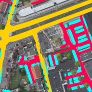
This inventory of traffic areas in the city of Brunswick, Germany, is based on image sequences acquired during six flight campaigns at different times of the day and year in 2019 and 2020. Each aerial image is segmented by a neural network into the classes (1) Parking area, (2) Road, and (3) Access way, with the latter two classes differing in terms of their primary transportation function (mobility versus access). The individual segmentations are subsequently merged, since in addition to dedicated parking areas, those traffic areas that are regularly used for parking a motorized vehicle (e.g., at the curbside) are also to be classified as such. Furthermore, the multitemporal fusion enhances the robustness and completeness of the traffic area map (TAM). Potential applications include: urban planning, traffic modeling, and parking management.
For more information about the project, the reader is referred to: https://elib.dlr.de/191145/1/Hellekes_et_al_2022_Parking_space_inventory_from_above.pdf
Simple
- Date (Creation)
- 2022-08-01T00:00:00
- Citation identifier
- https://geoservice.dlr.de/catalogue/srv/metadata/d47a2d18-8443-4428-837f-b079d171a7e7
- Presentation form
- Digital map
- Purpose
-
To provide an inventory of traffic areas in the city of Brunswick, Germany. The resulting map serves applications like urban planning, transport modeling, and traffic management.
- Status
- Completed
- Maintenance and update frequency
- Not planned
- Keywords
-
-
DLR
-
EOC
-
Aerial Imagery
-
Image Segmentation
-
Traffic Area Map
-
Parking Space Detection
-
Multitemporal Fusion
-
Brunswick
-
Germany
-
-
GEMET - INSPIRE themes, version 1.0
-
-
Transport networks
-
- Use limitation
-
Nutzungseinschränkungen: Das DLR ist nicht haftbar für Schäden, die sich aus der Nutzung ergeben. / Use Limitations: DLR not liable for damage resulting from use.
- Access constraints
- Other restrictions
- Other constraints
- Es gelten keine Zugriffsbeschränkungen
- Use constraints
- Other restrictions
- Other constraints
-
Nutzungsbedingungen: Lizenz, https://creativecommons.org/licenses/by-nc/4.0 / Terms of use: License, https://creativecommons.org/licenses/by-nc/4.0
- Other constraints
-
{"id": "cc-by-nc-4.0",
"name": "Creative Commons Namensnennung - Nicht kommerziell 4.0 International (CC BY-NC 4.0)",
"url": " http://dcat-ap.de/def/licenses/cc-by-nc/4.0 ",
"quelle": "Copyright DLR (year of production)"}
- Spatial representation type
- Grid
- Denominator
- 200
- Language
- Deutsch
- Character set
- UTF8
- Topic category
-
- Transportation
))
- Begin date
- 2019-04-25
- End date
- 2020-06-24
- Unique resource identifier
- EPSG:3035
- Number of dimensions
- 2
- Dimension name
- Column
- Dimension size
- 90000
- Resolution
- 0.1 m
- Dimension name
- Row
- Dimension size
- 56000
- Resolution
- 0.1 m
- Cell geometry
- Area
- Transformation parameter availability
- No
- Distribution format
-
-
Cloud Optimized GeoTIFF
(
)
-
Cloud Optimized GeoTIFF
(
)
- OnLine resource
-
URMO_TAM_3K_BRUNSWICK
(
OGC:WMS
)
WMS Access: inventory of traffic areas in the city of Brunswick, Germany
- OnLine resource
-
3K_MOS_BRUNSWICK
(
OGC:WMS
)
WMS Access: aerial imagery mosaic for the city of Brunswick, Germany
- OnLine resource
-
UrMo Digital - Forschen für die städtische Mobilität der Zukunft
(
WWW:LINK-1.0-http--link
)
Webpage with links and description for accessing more information about the project
- OnLine resource
-
HTTP download
(
WWW:LINK-1.0-http--link
)
HTTP download (UrMo Digital)
- Hierarchy level
- Dataset
Domain consistency
- Measure identification
- INSPIRE / Conformity_001
Conformance result
- Date (Publication)
- 2010-12-08
- Explanation
-
See the referenced specification
- Pass
- Yes
- Statement
-
The traffic are map for Brunswick, Germany is based on aerial images acquired with the DLR 3K camera system at varying times of the day and year between 2019 and 2020, covering about 36 km² with a spatial resolution of 0.1 m.
- Description
-
UrMo Digital - Traffic Area Map Processing
Data:
The classification is based on image sequences acquired during six flight campaigns at different times of the day and year in 2019 and 2020. Imagery was acquired with the 3K camera system at 10 cm ground sampling distance
Processing:
Each aerial image is segmented by a neural network, multi-temporal fusion is used to improve robustness and detect curbside parking areas.
- File identifier
- d47a2d18-8443-4428-837f-b079d171a7e7 XML
- Metadata language
- English
- Character set
- UTF8
- Hierarchy level
- Dataset
- Hierarchy level name
-
dataset
- Date stamp
- 2024-06-20T13:08:04
- Metadata standard name
-
ISO 19115-1:2014/19139
Overviews

Spatial extent
Provided by
