 www.geodatenkatalog.de (S3L)
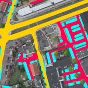
UrMo Digital - Traffic Area Map (TAM) - Brunswick, Germany
This inventory of traffic areas in the city of Brunswick, Germany, is based on image sequences acquired during six flight campaigns at different times of the day and year in 2019 and 2020. Each aerial image is segmented by a neural network into the classes (1) Parking area, (2) Road, and (3) Access way, with the latter two classes differing in terms of their primary transportation function (mobility versus access). The individual segmentations are subsequently merged, since in addition to dedicated parking areas, those traffic areas that are regularly used for parking a motorized vehicle (e.g., at the curbside) are also to be classified as such. Furthermore, the multitemporal fusion enhances the robustness and completeness of the traffic area map (TAM). Potential applications include: urban planning, traffic modeling, and parking management.
For more information about the project, the reader is referred to: https://elib.dlr.de/191145/1/Hellekes_et_al_2022_Parking_space_inventory_from_above.pdf
|
|
Citation proposal
Jens Hellekes (German Aerospace Center (DLR)). UrMo Digital - Traffic Area Map (TAM) - Brunswick, Germany. https://gdk.gdi-de.org/geonetwork/srv/api/records/d47a2d18-8443-4428-837f-b079d171a7e7 |
INSPIRE
Identification
- File identifier
- d47a2d18-8443-4428-837f-b079d171a7e7 XML
- Hierarchy level
- Dataset
Online resource
- Protocol
- OGC:WMS
- Protocol
- OGC:WMS
- Protocol
- WWW:LINK-1.0-http--link
- Protocol
- WWW:LINK-1.0-http--link
Resource identifier
- Metadata language
- German
- Spatial representation type
- Grid
Encoding
- Format
- Cloud Optimized GeoTIFF
- Version
- Specification
Projection
Classification of data and services
- Topic category
-
- Transportation
Classification of data and services
Coupled resource
Coupled resource
Classification of data and services
Coupled resource
Coupled resource
Keywords
- GEMET - INSPIRE themes, version 1.0 ( Theme )
-
- Transport networks
- Spatial scope ( Theme )
Other keywords
- Keywords
-
- DLR
- EOC
- Aerial Imagery
- Image Segmentation
- Traffic Area Map
- Parking Space Detection
- Multitemporal Fusion
- Brunswick
- Germany
Geographic coverage
))
Temporal reference
Temporal extent
Temporal extent
- Date ( Creation )
- 2022-08-01T00:00:00
Quality and validity
- Lineage
- The traffic are map for Brunswick, Germany is based on aerial images acquired with the DLR 3K camera system at varying times of the day and year between 2019 and 2020, covering about 36 km² with a spatial resolution of 0.1 m.
- Denominator
- 200
Conformity
Conformity
Conformity
Conformity
Conformity
Conformity
- Explanation
- See the referenced specification
Restrictions on access and use
- Access constraints
- Nutzungsbedingungen: Lizenz, https://creativecommons.org/licenses/by-nc/4.0 / Terms of use: License, https://creativecommons.org/licenses/by-nc/4.0
- Access constraints
-
{"id": "cc-by-nc-4.0",
"name": "Creative Commons Namensnennung - Nicht kommerziell 4.0 International (CC BY-NC 4.0)",
"url": "http://dcat-ap.de/def/licenses/cc-by-nc/4.0",
"quelle": "Copyright DLR (year of production)"}
Restrictions on access and use
Responsible organization (s)
Contact for the resource
- Organisation name
- German Aerospace Center (DLR)
- geoservice@dlr.de
- Organisation name
- German Aerospace Center (DLR)
- geoservice@dlr.de
- Organisation name
- German Aerospace Center (DLR)
- Jens.Hellekes@dlr.de
Responsible organization (s)
Contact for the resource
- Organisation name
- German Aerospace Center (DLR)
- geoservice@dlr.de
- Organisation name
- German Aerospace Center (DLR)
- geoservice@dlr.de
- Organisation name
- German Aerospace Center (DLR)
- Jens.Hellekes@dlr.de
Metadata information
Contact for the metadata
- Organisation name
- German Aerospace Center (DLR)
- geoservice@dlr.de
- Date stamp
- 2024-06-20T13:08:04
- Metadata language
- English
- Character set
- UTF8
SDS
Conformance class 1: invocable
Access Point URL
Endpoint URL
Technical specification
Conformance class 2: interoperable
Coordinate reference system
Quality of Service
Access constraints
Limitation
Use constraints
Limitation
Responsible custodian
Contact for the resource
Conformance class 3: harmonized
Overviews

Provided by
