 www.geodatenkatalog.de (S3L)
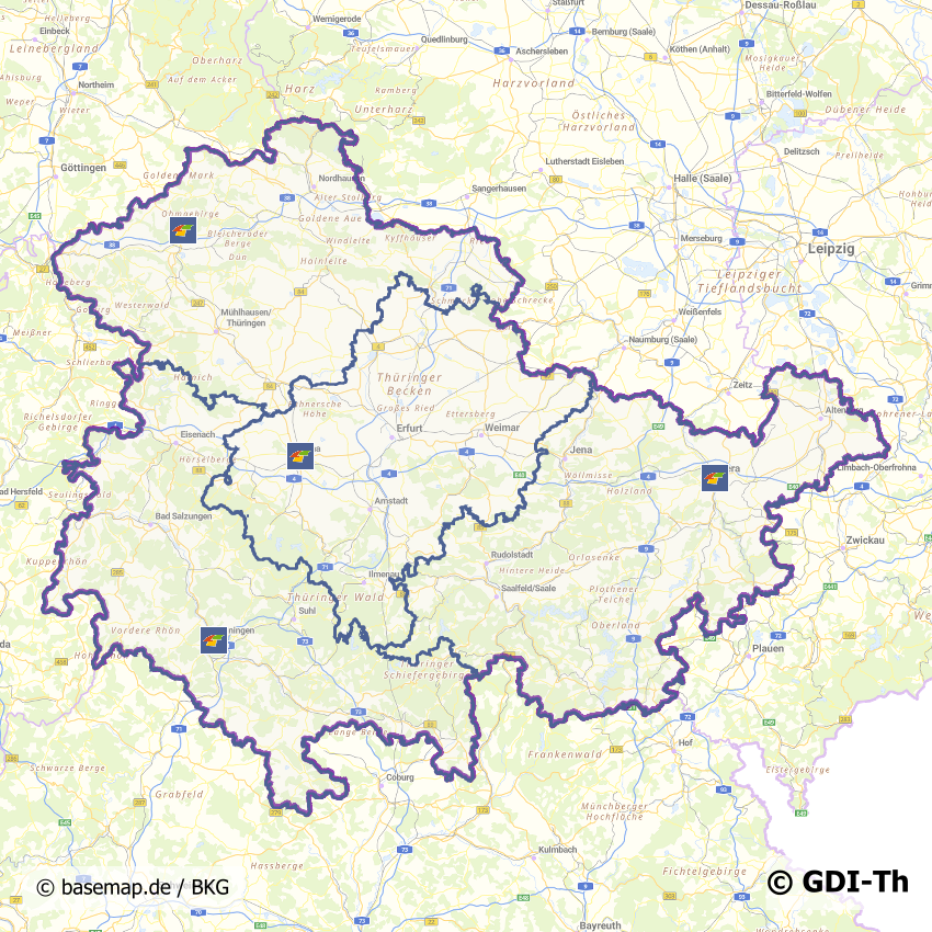
Flurbereinigungsbereiche in Thüringen
Thüringen ist in drei Flurbereinigungsbereiche aufgeteilt: Gera, Gotha und Meiningen. Diese sind jeweils für mehrere Landkreise zuständig.
Flurbereinigung verbindet zweckmäßige Neuordnung von ländlichem Grundbesitz mit Investitionen in die Infrastruktur im ländlichen Raum. Durch die Verbindung dieser beiden Komponenten dient die Flurbereinigung wie kein anderes Instrument dem Anspruch des ganzheitlichen Entwicklungsansatzes für die ländlichen Räume. Gesetzliche Grundlage ist das Flurbereinigungsgesetz.
|
|
Citation proposal
. Flurbereinigungsbereiche in Thüringen. https://gdk.gdi-de.org/geonetwork/srv/api/records/d5516171-448f-41f3-a9ef-a04f97008c6a |
INSPIRE
Identification
- File identifier
- d5516171-448f-41f3-a9ef-a04f97008c6a XML
- Hierarchy level
- Dataset
Online resource
- Protocol
- OGC:WMS-http-get-map
- Protocol
- WWW:LINK-1.0-http--link
Resource identifier
- Metadata language
- German
- Spatial representation type
- Vector
Encoding
- Format
- ESRI Shapefile
- Version
- 1.0
Projection
Classification of data and services
- Topic category
-
- Planning cadastre
Classification of data and services
Coupled resource
Coupled resource
Classification of data and services
Coupled resource
Coupled resource
Keywords
Other keywords
- Keywords
-
- Flurbereinigungsbereiche
- Flurbereinigung
- Flurbereinigungsgesetz
- Flurbereinigungsverfahren
- Bodenordnungsverfahren
- Freiwilliger Landtausch
- Flurbereinigungsgesetz
- LwAnpG
- opendata
- GOVE
- REGI
- JUST
- Thüringen
Geographic coverage
N
S
E
W
))
Temporal reference
Temporal extent
Temporal extent
- Date ( Creation )
- 2022-02-17
Quality and validity
- Lineage
- Die Zuständigkeiten orientieren sich an den Landkreisgrenzen.
- Distance
- 1 m
Conformity
Conformity
Conformity
Conformity
Conformity
Conformity
- Explanation
- Originäre Daten
Restrictions on access and use
- Access constraints
- Nutzungsbedingungen: Datenlizenz Deutschland-Namensnennung 2.0 in JSON Syntax
- Access constraints
- {"id": "dl-by-de/2.0", "name": "Datenlizenz Deutschland Namensnennung 2.0", "url": "https://www.govdata.de/dl-de/by-2-0 ", "quelle": "© GDI-Th"}
Restrictions on access and use
Responsible organization (s)
Contact for the resource
- Organisation name
- Thüringer Landesamt für Bodenmanagement und Geoinformation
Responsible organization (s)
Contact for the resource
- Organisation name
- Thüringer Landesamt für Bodenmanagement und Geoinformation
Metadata information
Contact for the metadata
- Organisation name
- Thüringer Landesamt für Bodenmanagement und Geoinformation
- Date stamp
- 2024-07-02T07:10:48
- Metadata language
- German
SDS
Conformance class 1: invocable
Access Point URL
Endpoint URL
Technical specification
Conformance class 2: interoperable
Coordinate reference system
Quality of Service
Access constraints
Limitation
Use constraints
Limitation
Responsible custodian
Contact for the resource
Conformance class 3: harmonized
Overviews
Vorschaubild
Provided by

Views
d5516171-448f-41f3-a9ef-a04f97008c6a
Access to the portal
Read here the full details and access to the data.
Associated resources
Not available