 www.geodatenkatalog.de (S3L)
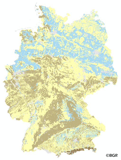
Air capacity of German soils
The map of the air capacity of soils in Germany gives an overview of the content of air in a soil at field capacity. The map shows the air, which is available for plant growth from the surface to effective rooting depth, which is derived from land use and soli data. The method is published in the Bodenkundliche Kartieranleitung 4 (1994) and in the documentation of Ad-hoc-AG Boden (representing the soil experts of the geological services of the German federal states). The land use information is derived from the Corine Land Cover data set (2006).
|
|
Citation proposal
(2015) . Air capacity of German soils. https://gdk.gdi-de.org/geonetwork/srv/api/records/d60d8925-06fd-455d-b5fe-62ad78766e0a |
Simple
- Alternate title
- LKWe1000_250
- Date ( Creation )
- 2014-06-20
- Date ( Publication )
- 2015-08-03
- Edition
- Version 2.0
- Identifier
- e5068530-8eb6-11e5-b4cd-8851fb422c62
Author
- Status
- completed Completed
Point of contact
Bundesanstalt für Geowissenschaften und Rohstoffe (BGR)
-
Stegger, Ulrich
Stilleweg 2
Hannover
30655
Deutschland
- GEMET - Concepts, version 2.4 ( Theme )
-
- Boden
- Bodenkarte
- Bodenluft
- Bodenwasserhaushalt
- GEMET - INSPIRE themes, version 1.0 ( Theme )
-
- Boden
- Soil
- SGD-Liste ( Theme )
-
- Porosität
- Freies Schlagwort ( Theme )
-
- Luft
- Keywords ( Place )
-
- Bundesrepublik Deutschland
- Access constraints
- Other restrictions
- Use constraints
- Other restrictions
- Other constraints
- Allgemeine Geschäftsbedingungen, siehe https://www.bgr.bund.de/AGB - General terms and conditions, see https://www.bgr.bund.de/AGB_en. Die bereitgestellten Informationen sind bei Weiterverwendung wie folgt zu zitieren: Datenquelle: LKWe1000_250 V2.0, (c) BGR, Hannover, 2015.
- Spatial representation type
- Grid
- Denominator
- 1000000
- Metadata language
- German
- Character set
- UTF8
- Topic category
-
- Geoscientific information
N
S
E
W
))
- Geographic identifier
- Regionalschlüssel / 000000000000
- Distribution format
-
- georef. TIFF (n/a )
- Transfer size
- 5
- OnLine resource
-
LKWe1000_250 (georef. TIFF)
LKWe1000_250 im Format georeferenziertes TIFF
- OnLine resource
- Website zum Thema
- OnLine resource
-
Karte im BGR-Geoviewer
Karte im BGR-Geoviewer
- Hierarchy level
- Dataset
Conformance result
- Date ( Publication )
- 2010-12-08
- Explanation
- siehe dazu die angegebene Durchführungsbestimmung
- Statement
- Bodendaten aus BÜK1000N V2.31 (BGR), Landnutzungsdaten aus CORINE Land Cover 2006 (UBA/DLR).
gmd:MD_Metadata
- File identifier
- d60d8925-06fd-455d-b5fe-62ad78766e0a XML
- Metadata language
- German
- Character set
- UTF8
- Hierarchy level
- Dataset
- Hierarchy level name
- Boden
- Date stamp
- 2025-03-12
- Metadata standard name
- INSPIRE Metadata Implementing Rules: Technical Guidelines based on EN ISO 19115 and EN ISO 19119
- Metadata standard version
- n/a
Point of contact
Overviews
Provided by

Views
d60d8925-06fd-455d-b5fe-62ad78766e0a
Access to the portal
Read here the full details and access to the data.
Associated resources
Not available