 www.geodatenkatalog.de (S2L)
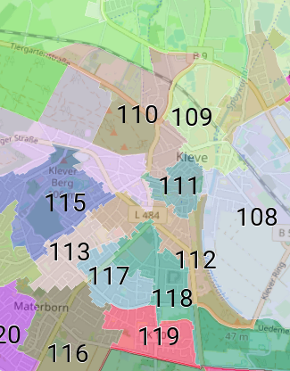
Ratswahlbezirke Kleve
Die Ratswahlbezirke werden räumlich anhand der durchschnittlichen Anzahl der Wahlberechtigten mit einer Abweichung von +/- 15% vom Durchschnitt innerhalb von Kleve vom Wahlausschuss festgesetzt.
Die Daten umfassen die aktuellen Wahlbezirksgeometrien. Sie werden vor jeder Wahl neu festgelegt bzw. beschlossen.
|
|
Citation proposal
(2024) . Ratswahlbezirke Kleve. Stadt Kleve https://gdk.gdi-de.org/geonetwork/srv/api/records/d6d55bb7-9dc7-481e-a945-57098ba7080b |
Simple
- Date ( Publication )
- 2024-11-19T00:00:00.000+01:00
Point of contact
Publisher
- Maintenance and update frequency
- As needed
- Update scope
- Dataset
- Keywords
-
- Ratswahlbezirke
- Stimmbezirke
- Wahlen
- Wahl
- Wahlkreis
- Wahlbezirk
- Kommunalwahl
- KW
- Kreis Kleve
- ARS
- Kleve
- 05154036
- Stadt Kleve
- UMTHES Thesaurus ( Theme )
- Use constraints
- Other restrictions
- Other constraints
- Datenlizenz Deutschland - Zero - Version 2.0 [https://www.govdata.de/dl-de/zero-2-0]
- Other constraints
- {"id":"dl-zero-de/2.0","name":"Datenlizenz Deutschland – Zero – Version 2.0","url":"https://www.govdata.de/dl-de/zero-2-0","quelle":""}
- Access constraints
- otherRestrictions Other restrictions
- Metadata language
- German
- Topic category
-
- Society
- Boundaries
- Extent type code
- true
- Geographic identifier
- Kleve, Gemeinde (051540036036)
N
S
E
W
))
- Extent type code
- true
- Distribution format
-
- ()
- OnLine resource
- Wahlbezirke Kreis Kleve
- OnLine resource
- WMS Wahlbezirke Kreis Kleve
- Hierarchy level
- Dataset
- Statement
- Kommunalwahlgesetz (KWahlG NRW)
- Description
- räumliches Zusammenfügen der Wahlberechtigten zu Bezirken
gmd:MD_Metadata
- File identifier
- d6d55bb7-9dc7-481e-a945-57098ba7080b XML
- Metadata language
- German
- Character set
- UTF8
- Parent identifier
- a6bb811e-ab7c-4f6d-8664-c99f53a990fb
- Hierarchy level
- dataset Dataset
- Date stamp
- 2024-11-28
- Metadata standard name
- ISO19115
- Metadata standard version
- 2003/Cor.1:2006
Point of contact
Kreis Kleve - Abt. Kataster- und Vermessung - Produktbereich GeoInformation (GIS)
Nassauerallee 15-23
Kleve
Nordrhein-Westfalen
47533
DEU
Overviews
Vorschau_Ratswahlbezirke_Kleve
Provided by

Views
d6d55bb7-9dc7-481e-a945-57098ba7080b
Access to the portal
Read here the full details and access to the data.
Associated resources
Not available