 www.geodatenkatalog.de (S1L)
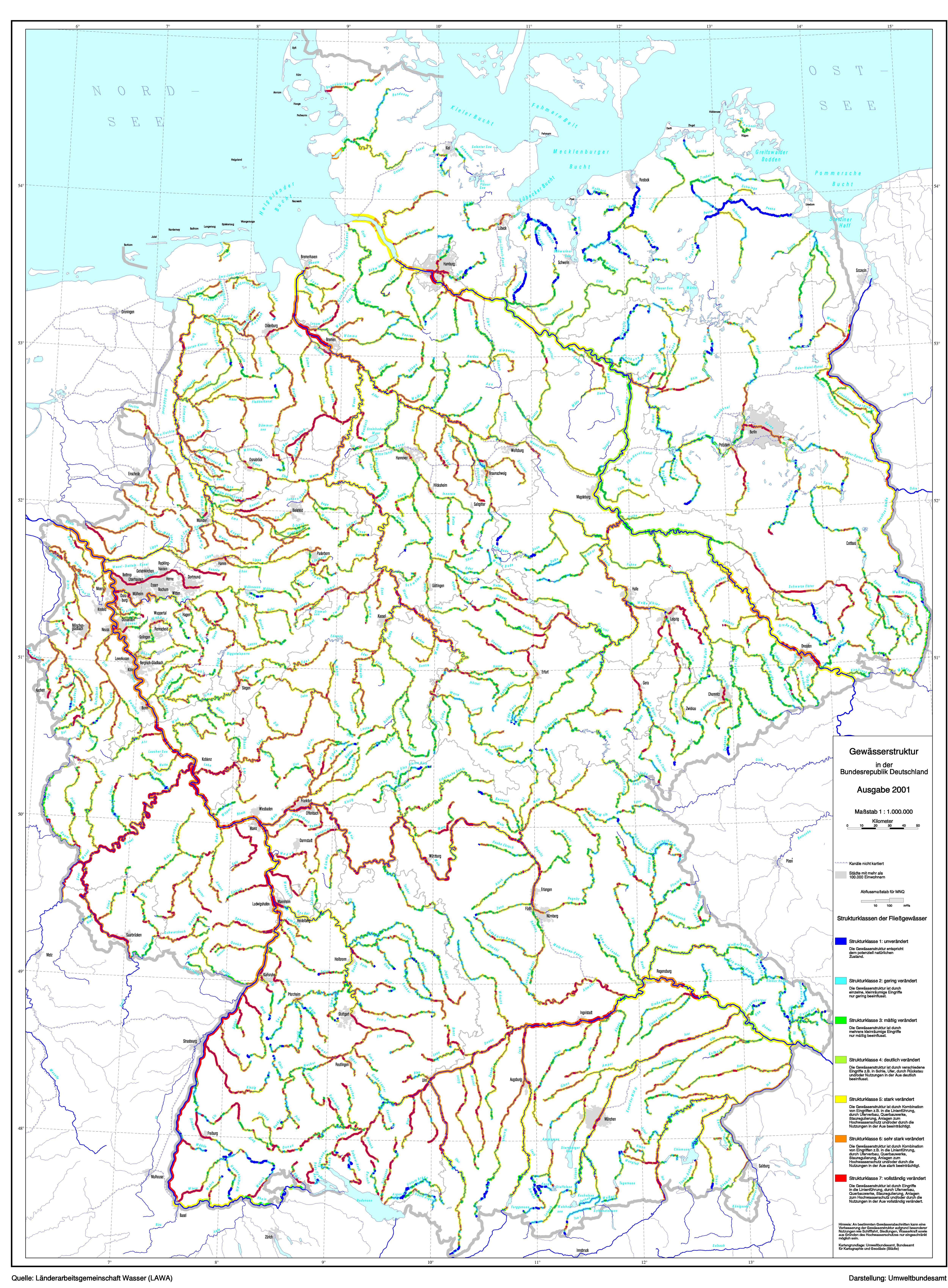
Gewässerstrukturkarte der Bundesrepublik Deutschland 2001
Gewässerstrukturkarte 2001
|
|
Citation proposal
(2012) . Gewässerstrukturkarte der Bundesrepublik Deutschland 2001. https://gdk.gdi-de.org/geonetwork/srv/api/records/d7255b1c-1e3f-41e6-9aeb-e8f3464cb567 |
- Identification
- Distribution
- Quality
- Spatial rep.
- Ref. system
- Content
- Portrayal
- Metadata
- Md. constraints
- Md. maintenance
- Schema info
Identification
Data identification
Citation
- Date ( Creation )
- 2002-01-01
- Date ( Publication )
- 2012-05-08
- Date ( Revision )
- 1998-06-01
Point of contact
- Keywords ( Theme )
-
- Fließgewässer
- Gewässerbelastung
- Gewässergüte
- Gewässerzustand
- Keywords ( Place )
-
- Deutschland
- Keywords ( Temporal )
-
- 2001
- Use limitation
- keine
Legal constraints
- Access constraints
- Other restrictions
- Other constraints
- keine
- Spatial representation type
- Vector
- Denominator
- 4000000
- Metadata language
- German
- Character set
- UTF8
- Topic category
-
- Inland waters
- Environment
N
S
E
W
))
Distribution
Distribution
Point of contact
- OnLine resource
- https://gis.uba.de/daten/gsk_2001.jpg
Quality
Data quality
Scope
- Hierarchy level
- Non geographic dataset
- Other
- Statement
- Datengrundlage: Wasserarbeitsgemeinschaft LAWA
Metadata
Metadata
- File identifier
- d7255b1c-1e3f-41e6-9aeb-e8f3464cb567 XML
- Metadata language
- German
- Character set
- UTF8
- Hierarchy level
- Non geographic dataset
- Hierarchy level name
- inlandWaters
- Date stamp
- 2022-06-28
- Metadata standard name
- ISO19115
- Metadata standard version
- 2003/Cor.1:2006
Point of contact
Overviews

Provided by

Views
d7255b1c-1e3f-41e6-9aeb-e8f3464cb567
Access to the portal
Read here the full details and access to the data.
Associated resources
Not available