• www.geodatenkatalog.de (S2L)
  •  
  •  
  •  

  Processed seismic data of Cruise SO137 GINCO I 1998

During RV SONNE cruise 137 from 21st November to 28th December 1998 Geoscientific Investigations on the active Convergence Zone between the east Eurasian and Indo-Australian Plate (GINCO I) were carried out along the Sunda Arc, off Sumatra, Java and the Sunda Strait. The studies were headed by the BGR in close cooperation with German and Indonesian research institutions. A total amount of 5,500 km of magnetic, gravity and swath bathymetric profiles were recorded of which multi-channel seismic data exceeded 4,100 km. The scientific objectives were: (1) investigation of the structure and age of the accretionary wedges, outer arc highs and fore-arc basins off Sumatra and Java with special emphasis on the evolution of the Sunda Strait and the Krakatau area (2) differences in tectonic deformation between oblique (Sumatra) versus frontal (Java) subduction (3) search for oceanic crustal splinters in the accretionary wedges (4) definition of seismic sequences, thicknesses and ages of the fore-arc basin sediments as a pre-requisite for later on hydrocarbon assessments (5) identification and regional occurrence of bottom simulating reflectors (BSR) indicating gas hydrates. From the GINCO I project there is evidence for the existence of two accretionary wedges along the Sunda Arc: wedge I is of assumed Paleogene age and wedge II of Neogene to Recent age. The first inner wedge I is composed of tectonic flakes which are correlated from SE Sumatra across the southern Sunda Strait to NW Java. This implies a very similar plate tectonic regime at the time of the flake development during the Upper Oligocene to Lower Miocene and without marked differences in plate convergence direction from Java to Sumatra. Wedge I shows backthrusting along the northern transition toward the fore-arc basin. Today, wedge I forms the outer arc high and the backstop for the younger, outer wedge II. Magnetic, gravity and seismic results show, that within both wedges, there are no indications for an oceanic crustal splinter as hitherto postulated. Both wedges are underlain by oceanic crust of the subducting Indo-Australian slab which could be correlated from the trench off Sumatra up to 135 km to the northeast and up to 65 km from the trench off Java. Since the top of the oceanic crust differs considerably in reflectivity and surface relief we distinguished two types in the seismic records. One type is characterized by strong top reflections and a smooth surface and underlies accretionary wedge II and the southwest part of the wedge I (outer arc high) off Sumatra and Java. The second type has a low reflectivity and a rougher relief and underlies the tectonic flakes of accretionary wedge I (outer arc high) between the southwestern tip of Sumatra, the SundaStrait and NW Java. The missing outer arc high off the southern entrance of the Sunda Strait is explained by Neogene transtension in combination with arc-parallel strike-slip movements. The NW-SE running, transpressional Mentawai strike-slip fault zone (MFZ) was correlated from the SE Sumatra fore-arc basin to the NW Java fore-arc basin. Off the Sunda Strait northward bending branches of the MFZ are connected with the Sumatra Fault zone (SFZ). It is speculated that the SFZ originally was attached to the Cimandiri-Pelabuhan-Ratu strike-slip faults and shifted from the volcanic arc position into the fore-arc basin area due to clockwise rotation of Sumatra with respect to Java as well as due to increasingly oblique plate convergence since the late Lower Miocene. We explain the transtension of the western Sunda Strait (Semangka graben) and the transpression with inversion of the eastern Sunda Strait, along the newly detected Krakatau Basin, by this rotation. Seismostratigraphic interpretation revealed 5 main sequences (A - E), tentatively dated as Paleogene to Recent in age. The oldest seismic sequence A of assumed Eocene to Oligocene age is bounded at the top by a major erosional unconformity that was identified on all GINCO seismic profiles. The seaward diverging seismic pattern of sequence A is interpreted as a correlative sequence to the prograding Paleogene deltaic sediments encountered by wells offshore central and northern Sumatra. This is opposed to previous interpretation which assumed seaward dipping reflector sequences of basaltic origin erupted along the former Mesozoic passive margin of Sumatra. According to constructed time structure maps, the main NW-SE running depocentres of the post-Paleogene sediments are arc-parallel off Sumatra and Java with thicknesses of 3 s (TWT) and 5 s (TWT), respectively. The main depocentres of the Semangka graben and of the Krakatau Basin of the Sunda Strait strike north-south and have infills of 2 s - 5 s (TWT). Bottom simulating reflectors (BSR) occur within the upper sequences C - D along the flanks of the fore-arc basins and along doming structures but could not be detected in basin centres. Empiric relations of heat flow values and depths of BSR were determined indicating that with increasing waterdepth and decreasing heat flow the depths of the BSR increase.
 
Citation proposal
. Processed seismic data of Cruise SO137 GINCO I 1998. https://gdk.gdi-de.org/geonetwork/srv/api/records/d84b85d7-1b1f-4d9d-8ec9-5e3aa2c6bdd3
 

Simple

Alternate title
SO137 GINCO I 1998
Date ( Creation )
1998-12-28
Identifier
5d32c875-b42b-2db2-9be4-44d2d9898d00
Status
completed Completed

  Point of contact

Federal Institute for Geosciences and Natural Resources  
Stilleweg 2 Hannover 30655

GEMET - INSPIRE themes, version 1.0 ( Theme )
  • Geologie
  • geology
GEMET - Concepts, version 2.4 ( Theme )
  • geophysics
  • Geophysik
  • raw material
  • Rohstoff
Keywords ( Theme )
  • Marine geology
  • Meeresgeologie
  • Seismics
  • Seismik
  • Two-dimensional seismic reflection
  • zweidimensionale Reflektionsseismik
Keywords ( Place )
  • Indian Ocean
  • Sunda Arc
  • Sunda Strait
  • Indischer Ozean
  • Sundabogen
  • Sundastraße
  • Sumatra
  • Java
Access constraints
Other restrictions
Use constraints
Other restrictions
Other constraints
Allgemeine Geschäftsbedingungen, siehe http://www.bgr.bund.de/AGB - General terms and conditions, see http://www.bgr.bund.de/AGB_en. Die bereitgestellten Informationen sind bei Weiterverwendung wie folgt zu zitieren: Datenquelle: SO137 GINCO I 1998, (c) BGR, Hannover, 2019
Spatial representation type
Vector
Metadata language
English
Character set
UTF8
Topic category
  • Geoscientific information
N
S
E
W


Distribution format
  • Shapefile (n/a )

Transfer size
2
OnLine resource
SO137 GINCO I 1998 (Shapefile)  

SO137 GINCO I 1998 im Format ESRI Shape

OnLine resource
Profile SO137-01  

Profile SO137-01

OnLine resource
Profile SO137-02  

Profile SO137-02

OnLine resource
Profile SO137-03  

Profile SO137-03

OnLine resource
Profile SO137-04  

Profile SO137-04

OnLine resource
Profile SO137-06  

Profile SO137-06

OnLine resource
Profile SO137-06A  

Profile SO137-06A

OnLine resource
Profile SO137-07  

Profile SO137-07

OnLine resource
Profile SO137-09  

Profile SO137-09

OnLine resource
Profile SO137-09A  

Profile SO137-09A

OnLine resource
Profile SO137-10  

Profile SO137-10

OnLine resource
Profile SO137-11  

Profile SO137-11

OnLine resource
Profile SO137-12  

Profile SO137-12

OnLine resource
Profile SO137-12A  

Profile SO137-12A

OnLine resource
Profile SO137-14  

Profile SO137-14

OnLine resource
Profile SO137-14A  

Profile SO137-14A

OnLine resource
Profile SO137-14B  

Profile SO137-14B

OnLine resource
Profile SO137-19  

Profile SO137-19

OnLine resource
Profile SO137-20  

Profile SO137-20

OnLine resource
Profile SO137-21  

Profile SO137-21

OnLine resource
Profile SO137-22  

Profile SO137-22

OnLine resource
Profile SO137-23  

Profile SO137-23

OnLine resource
Profile SO137-25  

Profile SO137-25

OnLine resource
Profile SO137-26  

Profile SO137-26

OnLine resource
Profile SO137-27  

Profile SO137-27

OnLine resource
Profile SO137-28  

Profile SO137-28

OnLine resource
Profile SO137-29  

Profile SO137-29

OnLine resource
Profile SO137-30  

Profile SO137-30

OnLine resource
Profile SO137-31  

Profile SO137-31

OnLine resource
Profile SO137-32  

Profile SO137-32

OnLine resource
Profile SO137-33  

Profile SO137-33

OnLine resource
Profile SO137-34  

Profile SO137-34

OnLine resource
Profile SO137-34A  

Profile SO137-34A

OnLine resource
Profile SO137-36  

Profile SO137-36

OnLine resource
Profile SO137-36A  

Profile SO137-36A

OnLine resource
Profile SO137-36B  

Profile SO137-36B

OnLine resource
Profile SO137-37  

Profile SO137-37

OnLine resource
Profile SO137-38  

Profile SO137-38

OnLine resource
Profile SO137-38A  

Profile SO137-38A

OnLine resource
Profile SO137-39  

Profile SO137-39

OnLine resource
Profile SO137-39A  

Profile SO137-39A

OnLine resource
Profile SO137-40  

Profile SO137-40

OnLine resource
Profile SO137-41  

Profile SO137-41

OnLine resource
Profile SO137-42  

Profile SO137-42

OnLine resource
Profile SO137-42A  

Profile SO137-42A

OnLine resource
Profile SO137-42B  

Profile SO137-42B

OnLine resource
Karte im BGR-Geoviewer  

Karte im BGR-Geoviewer

Hierarchy level
Dataset

Conformance result

Date ( Publication )
2010-12-08
Explanation
siehe dazu die angegebene Durchführungsbestimmung
Statement
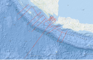
During the period from 21st November to 28th December 1998 BGR acquired seismic lines off Sumatra and Java during cruise SO137 with RV SONNE. The lines SO137-24, SO137-35 and SO137-35C are raw data. The lines SO137-01, SO137-02, SO137-03, SO137-06, SO137-06A, SO137-07, SO137-09, SO137-09A, SO137-10, SO137-11, SO137-12, SO137-12A, SO137-14, SO137-14A, SO137-14B, SO137-19, SO137-20, SO137-21, SO137-22, SO137-23, SO137-25, SO137-26, SO137-27, SO137-28, SO137-29, SO137-30, SO137-31, SO137-32, SO137-33, SO137-34, SO137-34A, SO137-36, SO137-36A, SO137-37, SO137-38, SO137-38A, SO137-39, SO137-39A, SO137-40, SO137-41, SO137-42, SO137-42A and SO137-42B are migrated data.

gmd:MD_Metadata

File identifier
d84b85d7-1b1f-4d9d-8ec9-5e3aa2c6bdd3   XML
Metadata language
English
Character set
UTF8
Parent identifier
06a73c56-06a2-40d8-b806-466222b0760d
Hierarchy level
Dataset
Hierarchy level name
Geophysik
Date stamp
2023-11-16
Metadata standard name
INSPIRE Metadata Implementing Rules: Technical Guidelines based on EN ISO 19115 and EN ISO 19119
Metadata standard version
n/a

  Point of contact

Bundesanstalt für Geowissenschaften und Rohstoffe (BGR)  

Website
https://produktcenter.bgr.de  


  Overviews

  Provided by

  Views

  • INSPIRE
  • Simple
  • Full
  • XML
d84b85d7-1b1f-4d9d-8ec9-5e3aa2c6bdd3   Access to the portal Read here the full details and access to the data.

  Associated resources

Not available


  •  
  •