 www.geodatenkatalog.de (S1L)
Processed seismic data of Cruise AL278 2006
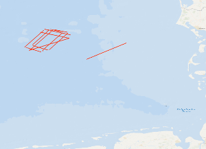
The cruise AL278 started on May, 10th 2006 in Kiel and ended in Kiel on May, 19th 2006. The previous BGR-cruises with RV AURELIA in 2003 and 2004 were designed to collect a grid of seismic MCS-data which should enable us to get a high-resolution overview over the upper 1 s TWT of the sediments of the German North Sea sector. During October/November 2005 a subsequent cruises with RV HEINCKE and FK SENCKENBERG was designed to tackle several special aims: - The detailed mapping of glacio-tectonic features North of Heligoland. - The shallow seismic mapping of the Holocene/Pleistocene-Boundary and topography of the Pleistocene sub-glacial valley system offshore of the East Friesian Islands. - High-resolution surveying of two areas designated for offshore wind farms in the southwestern German sector. - Detailed mapping of a wide and deep sub-glacial valley. One additional aim was to acquire a dense grid of seismic line in the area North of Weisse Bank where on several from previous cruises indications for shallow gas accumulations (e.g. “bright spots”) were found. Unfortunately, due to very bad weather conditions this aim could not be reached. Therefore this short cruise with RV ALKOR was used to acquire twelve MCS lines over this area. During the cruise a total ca. 1400 km of high quality MCS lines were surveyed and simultaneously measured by a sediment echosounder system that enabled additional profiles during transits with speeds 5 kn. Together with the previously acquired data these new data should help to extend our knowledge of the Late Tertiary and Quaternary evolution of the German North Sea Sector. The BGR high-resolution multichannel seismic reflection system consisting of a GI-Gun (0.8 l) and a 300 m streamer with 24 channels and a sediment echosounder type SES 2000 standard by Innomar, Rostock. While the BGR-seismic system was used to observe the shallow subsurface down to 2 s TWT penetration depth, the sediment echosounder with a penetration depth of several meters was primarily intended to identify sampling positions for the deployment of the BGR vibration corer during the succeeding Leg 2. Additionally, the echosounder system enables the relationship to the highest-resolution multichannel seismic measurements of the group of the University of Bremen on FK SENCKENBERG. All seismic records were processed onboard for the quality control and for a first interpretation.
|
|
Citation proposal
(2006) . Processed seismic data of Cruise AL278 2006. https://gdk.gdi-de.org/geonetwork/srv/api/records/d973f1af-db9f-4632-bd05-8964cc906b38 |
Simple
- Alternate title
- AL278 2006
- Date ( Publication )
- 2006-05-19
- Identifier
- b62a8da0-e746-aab6-f180-38893a8f03c5
- Status
- completed Completed
Point of contact
- GEMET - INSPIRE themes, version 1.0 ( Theme )
-
- Geologie
- geology
- GEMET - Concepts, version 2.4 ( Theme )
-
- geophysics
- Geophysik
- raw material
- Rohstoff
- Keywords ( Theme )
-
- Marine geology
- Meeresgeologie
- Seismics
- Seismik
- Two-dimensional seismic reflection
- zweidimensionale Reflektionsseismik
- GeolDG
- Keywords ( Place )
-
- German North Sea
- Nordsee
- German Bight
- Deutsche Bucht
- Access constraints
- Other restrictions
- Use constraints
- Other restrictions
- Other constraints
- Allgemeine Geschäftsbedingungen, siehe http://www.bgr.bund.de/AGB - General terms and conditions, see http://www.bgr.bund.de/AGB_en. Die bereitgestellten Informationen sind bei Weiterverwendung wie folgt zu zitieren: Datenquelle: AL278 2006, (c) BGR, Hannover, 2021
- Metadata language
- English
- Character set
- UTF8
- Topic category
-
- Geoscientific information
N
S
E
W
))
- Distribution format
-
- Shapefile (n/a )
- Transfer size
- 1
- OnLine resource
-
AL278 2006 (Shapefile)
AL278 2006 im Format ESRI Shape
- OnLine resource
-
Profile AL278-01
Profile AL278-01
- OnLine resource
-
Profile AL278-02
Profile AL278-02
- OnLine resource
-
Profile AL278-03
Profile AL278-03
- OnLine resource
-
Profile AL278-04
Profile AL278-04
- OnLine resource
-
Profile AL278-05
Profile AL278-05
- OnLine resource
-
Profile AL278-06
Profile AL278-06
- OnLine resource
-
Profile AL278-07
Profile AL278-07
- OnLine resource
-
Profile AL278-08
Profile AL278-08
- OnLine resource
-
Profile AL278-09
Profile AL278-09
- OnLine resource
-
Profile AL278-10
Profile AL278-10
- OnLine resource
-
Profile AL278-11
Profile AL278-11
- OnLine resource
-
Profile AL278-12
Profile AL278-12
- OnLine resource
-
Profile AL278-13
Profile AL278-13
- OnLine resource
-
Karte im BGR-Geoviewer
Karte im BGR-Geoviewer
- Hierarchy level
- Dataset
Conformance result
- Date ( Publication )
- 2010-12-08
- Explanation
- siehe dazu die angegebene Durchführungsbestimmung
- Statement
- During the period from the 12th of May 2006 to the 17th of May 2006 BGR acquired seismic lines in the German Bight. The lines AL278-01 to AL278-13 consist of stacked data.
gmd:MD_Metadata
- File identifier
- d973f1af-db9f-4632-bd05-8964cc906b38 XML
- Metadata language
- English
- Character set
- UTF8
- Parent identifier
- 06a73c56-06a2-40d8-b806-466222b0760d
- Hierarchy level
- Dataset
- Hierarchy level name
- Geophysik
- Hierarchy level name
- GeolDG
- Date stamp
- 2024-03-04
- Metadata standard name
- INSPIRE Metadata Implementing Rules: Technical Guidelines based on EN ISO 19115 and EN ISO 19119
- Metadata standard version
- n/a
Point of contact
Overviews
Provided by

Views
d973f1af-db9f-4632-bd05-8964cc906b38
Access to the portal
Read here the full details and access to the data.
Associated resources
Not available