 www.geodatenkatalog.de (S3L)
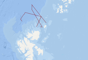
Processed seismic data of Cruise BGR13-2 2013 (PANORAMA-1)
The research cruise PANORAMA-1 onboard the Italian vessel OGS Explora was carried out within 2 legs in the period August, 16th – September 17th 2013. The designated survey area was located in a sector of the European Arctic north of Svalbard covering an area north of 80°N between 15°E and 35°E. Main objectives were to acquire new geophysical data and extract near surface sediment samples in an underexplored area of the European Arctic with special focus on the transition zone from the North Barents shelf towards the oceanic Nansen basin. During leg 1 of the cruise a 20 days geophysical survey 1056 km of multi-channel seismic data was acquired supplemented by a 221 km long sonobuoy profile. Additionally, magnetic and sediment echosounding data was acquired along these profiles. During all operations within the survey area gravity and multibeam echosounding data was continuously acquired. After a 1 day stopover in Longyearbyen in order to exchange part of the scientific crew OGS Explora returned to the survey area to continue survey operations during leg 2. Within these 10 days period near surface sediments were extracted by means of a gravity corer at 12 locations and heat flow soundings were conducted at 7 locations. Gravity, sediment and multibeam echosounding data was continuously acquired along all transit lines within the survey area during leg 2. Total line length of magnetic data was 2658.7 km. Over all track lines with bathymetric and gravity data amount to 5665.8 km in total.
|
|
Citation proposal
. Processed seismic data of Cruise BGR13-2 2013 (PANORAMA-1). https://gdk.gdi-de.org/geonetwork/srv/api/records/db44b03e-70df-43e2-baad-7a5ce4764b24 |
- Identification
- Distribution
- Quality
- Spatial rep.
- Ref. system
- Content
- Portrayal
- Metadata
- Md. constraints
- Md. maintenance
- Schema info
Identification
Data identification
Citation
- Alternate title
- BGR13-2 2013 (PANORAMA-1)
- Date ( Creation )
- 2013-09-17
- Identifier
- b091b5e4-c99e-4765-5b25-9a7825a19b67
- Status
- completed Completed
Point of contact
Federal Institute for Geosciences and Natural Resources
-
Christian Müller
Stilleweg 2
Hannover
30655
- GEMET - INSPIRE themes, version 1.0 ( Theme )
-
- Geologie
- geology
- Keywords ( Place )
-
- Barents Sea
- Barentssee
- Nansen Basin
- Nansen-Becken
- Spitzbergen
- Svalbard
- GEMET - Concepts, version 2.4 ( Theme )
-
- geophysics
- Geophysik
- raw material
- Rohstoff
- Keywords ( Theme )
-
- Marine geology
- Meeresgeologie
- Seismics
- Seismik
- Two-dimensional seismic reflection
- zweidimensionale Reflektionsseismik
Legal constraints
- Access constraints
- Other restrictions
Legal constraints
- Use constraints
- Other restrictions
- Other constraints
- Allgemeine Geschäftsbedingungen, siehe https://www.bgr.bund.de/AGB - General terms and conditions, see https://www.bgr.bund.de/AGB_en. Die bereitgestellten Informationen sind bei Weiterverwendung wie folgt zu zitieren: Datenquelle: BGR13-2 2013 (PANORAMA-1), (c) BGR, Hannover, 2021
- Metadata language
- English
- Character set
- UTF8
- Topic category
-
- Geoscientific information
N
S
E
W
))
Distribution
Distribution
- Distribution format
-
- Shapefile (n/a )
Digital transfer options
- Transfer size
- 2
- OnLine resource
-
BGR13-2 2013 (PANORAMA-1) (Shapefile)
BGR13-2 2013 (PANORAMA-1) im Format ESRI Shape
- OnLine resource
-
Karte im BGR-Geoviewer
Karte im BGR-Geoviewer
Quality
Data quality
Scope
- Hierarchy level
- Dataset
Conformance result
Citation
- Date ( Publication )
- 2010-12-08
- Explanation
- siehe dazu die angegebene Durchführungsbestimmung
- Statement
- During the period from the 16th of August to the 17th of September 2013 BGR acquired seismic lines north of Svalbard. The lines BGR13-201, BGR13-202, BGR13-203, BGR13-204, BGR13-205, BGR13-206, BGR13-207, BGR13-208 and BGR13-209 consist of migrated data.
Metadata
Metadata
- File identifier
- db44b03e-70df-43e2-baad-7a5ce4764b24 XML
- Metadata language
- English
- Character set
- UTF8
- Parent identifier
- 06a73c56-06a2-40d8-b806-466222b0760d
- Hierarchy level
- Dataset
- Hierarchy level name
- Geophysik
- Date stamp
- 2025-02-12
- Metadata standard name
- INSPIRE Metadata Implementing Rules: Technical Guidelines based on EN ISO 19115 and EN ISO 19119
- Metadata standard version
- n/a
Point of contact
Overviews
Provided by

Views
db44b03e-70df-43e2-baad-7a5ce4764b24
Access to the portal
Read here the full details and access to the data.
Associated resources
Not available