 www.geodatenkatalog.de (S3L)
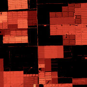
Geo-ForPy - Forest Cover Changes in the Paraguayan Chaco - Landsat-5/7/8,1987-2020
The dataset is based on the analysis of forest cover dynamics in the Paraguayan Chaco (northeastern part of Paraguay) between 1987 and 2020. The underlying forest masks were derived through annual forst classifications with a Random-Forest-Classifier trained on Landsat data from 1987 until 2020. The map shows the year in which the forest area was lost.
|
|
Citation proposal
German Aerospace Center (DLR). Geo-ForPy - Forest Cover Changes in the Paraguayan Chaco - Landsat-5/7/8,1987-2020. https://gdk.gdi-de.org/geonetwork/srv/api/records/dbc3ec56-a9d7-4050-ad14-1ff2e72a753 |
INSPIRE
Identification
- File identifier
- dbc3ec56-a9d7-4050-ad14-1ff2e72a753 XML
- Hierarchy level
- Dataset
Online resource
- Protocol
- OGC:WMS
- Protocol
- WWW:LINK-1.0-http--link
- Protocol
- WWW:LINK-1.0-http--link
- Protocol
- WWW:LINK-1.0-http--link
Resource identifier
- Metadata language
- English
- Spatial representation type
- Grid
Encoding
- Format
- Cloud Optimized GeoTIFF
Projection
Classification of data and services
- Topic category
-
- Biota
Classification of data and services
Coupled resource
Coupled resource
Classification of data and services
Coupled resource
Coupled resource
Keywords
- GEMET - INSPIRE themes, version 1.0 ( Theme )
-
- Land cover
- Spatial scope
Other keywords
- Keywords
-
- opendata
- DLR
- EOC
- GeoForPy
- Forest
- Forest Cover
- Landsat-5
- Landsat-7
- Landsat-8
- Paraguay
- Time Series
Geographic coverage
N
S
E
W
))
Temporal reference
Temporal extent
Temporal extent
- Date ( Creation )
- 2022-09-01T00:00:00
Quality and validity
- Lineage
- This data set provides an overview of 34 years of forest cover losses in the Paraguayan Chaco. The year in which there was the last change of an area from forest to non-forest is represented by its colour. Afforestaton cannot be represented in this dataset.
- Denominator
- 60000
Conformity
Conformity
Conformity
Conformity
Conformity
Conformity
- Explanation
- See the referenced specification.
Restrictions on access and use
- Access constraints
- Nutzungsbedingungen: Lizenz, https://creativecommons.org/licenses/by/4.0/ Terms of use: License, https://creativecommons.org/licenses/by/4.0/
- Access constraints
-
{"id": "cc-by-4.0",
"name": "Creative-Commons - Attribution 4.0 International (CC BY 4.0)",
"url": "http://dcat-ap.de/def/licenses/cc-by/4.0",
"quelle": "Copyright DLR (2022)"}
Restrictions on access and use
Responsible organization (s)
Contact for the resource
- Organisation name
- German Aerospace Center (DLR)
- Jennifer.Kriese@dlr.de
- Organisation name
- German Aerospace Center (DLR)
- geoservice@dlr.de
Responsible organization (s)
Contact for the resource
- Organisation name
- German Aerospace Center (DLR)
- Jennifer.Kriese@dlr.de
- Organisation name
- German Aerospace Center (DLR)
- geoservice@dlr.de
Metadata information
Contact for the metadata
- Organisation name
- German Aerospace Center (DLR)
- geoservice@dlr.de
- Date stamp
- 2024-06-20T13:07:37
- Metadata language
- English
- Character set
- UTF8
SDS
Conformance class 1: invocable
Access Point URL
Endpoint URL
Technical specification
Conformance class 2: interoperable
Coordinate reference system
Quality of Service
Access constraints
Limitation
Use constraints
Limitation
Responsible custodian
Contact for the resource
Conformance class 3: harmonized
Overviews

large_thumbnail
thumbnail
Provided by

Views
dbc3ec56-a9d7-4050-ad14-1ff2e72a753
Access to the portal
Read here the full details and access to the data.
Associated resources
Not available