 www.geodatenkatalog.de (S3L)
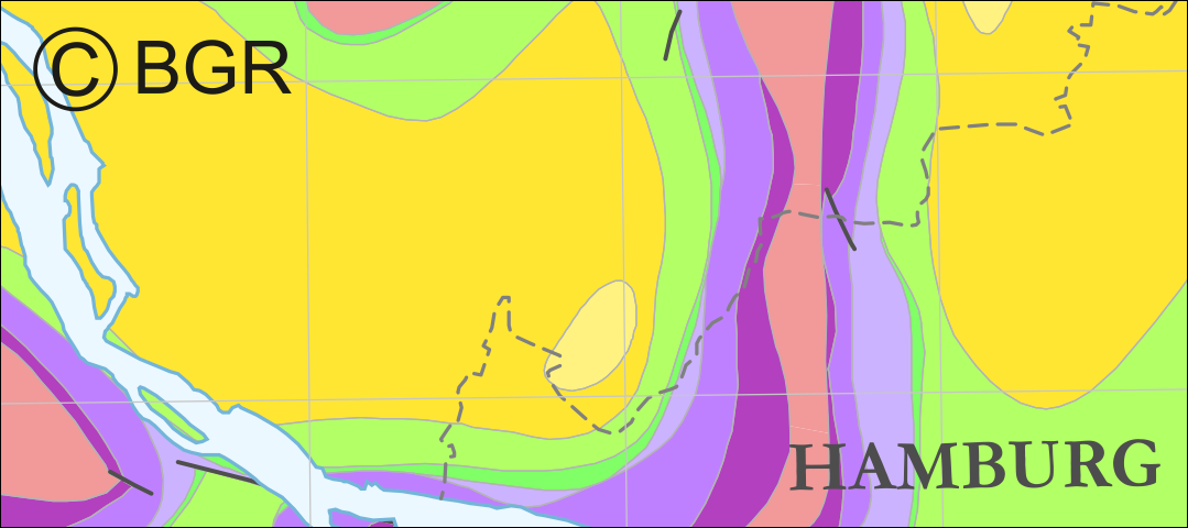
Horizontal cross-section maps of Northern Germany
Horizontal cross-section maps display the geological situation at a given depth. In concurrence of maps at different depths areal bedding conditions can be determined, e.g. to generally assess and interpret the spread of different stratigraphic units. Clearly visible are extent and shape of the salt structures within their regional context at the different depths, with extent and boundary of the salt structures having been the main focus of the project. Four horizontal cross-section maps covering the whole onshore area of Northern Germany have been developed at a scale of 1:500.000. The maps cover the depths of -500, -1000, -1500, -2000 m below NN. The four depths were selected by the project partners and are based on typical depth requirements of existing salt caverns in Northern Germany, mainly related to hydrocarbon storage. The shapes of the structures show rudimentary information of their geometry and their change with depths. In addition they form the starting point for rock mechanical calculations necessary for the planning and construction of salt caverns for storage as well as for assessing storage potentials. The maps can be used as a pre-selection tool for subsurface uses. It can also be used to assess coverage and extension of salt structures. As, at the time of preparation of the maps, energy storage and cavern operation in offshore areas could not be assumed as a priority, such areas were not treated within the project. All horizontal cross-section maps were adjusted with the respective state geological survey organisations.
|
|
Citation proposal
(2015) . Horizontal cross-section maps of Northern Germany. https://gdk.gdi-de.org/geonetwork/srv/api/records/dc32681d-02e5-4a2b-a888-701b2d5d942e |
INSPIRE
Identification
- File identifier
- dc32681d-02e5-4a2b-a888-701b2d5d942e XML
- Hierarchy level
- Dataset
Online resource
Resource identifier
- code
- 96b19435-d27c-4630-96fd-80680e7b2938
- Metadata language
- German
- Spatial representation type
- Vector
Encoding
- Format
- WMS
- Version
- OGC:WMS 1.3.0
Projection
Classification of data and services
- Topic category
-
- Geoscientific information
Classification of data and services
Coupled resource
Coupled resource
Classification of data and services
Coupled resource
Coupled resource
Keywords
- GEMET - INSPIRE themes, version 1.0 ( Theme )
-
- Geologie
- geology
- GEMET - Concepts, version 2.4 ( Theme )
-
- Salzstock
- Erneuerbare Energiequelle
Other keywords
- Keywords ( Place )
-
- Norddeutschland
- Norddeutsches Becken
- Keywords ( Theme )
-
- Diapir
- Jura
- Keuper
- Zechstein
- Energieträger
- Perm
- Salinar
- Salzintrusion
- Salzkissen
- Salzstruktur
Geographic coverage
N
S
E
W
))
Temporal reference
Temporal extent
Temporal extent
- Date ( Publication )
- 2015-11-23
Quality and validity
- Lineage
- Baldschuhn R. , Frisch, U. & Kockel, F. [Hrsg.] (1996): Geotektonischer Atlas von NW-Deutschland. Reinhardt, H.-G. (1989): Tiefender Horizonte T9 /X1 /X2 - Regionales reflexionsseismisches Kartenwerk, VEB Geophysik Leipzig (unveröff.).
- Denominator
- 500000
Conformity
Conformity
Conformity
Conformity
Conformity
Conformity
- Explanation
- siehe dazu die angegebene Durchführungsbestimmung
Restrictions on access and use
- Access constraints
- Allgemeine Geschäftsbedingungen, siehe https://www.bgr.bund.de/AGB - General terms and conditions, see https://www.bgr.bund.de/AGB_en. Die bereitgestellten Informationen sind bei Weiterverwendung wie folgt zu zitieren: Datenquelle: InSpEE-Niveauschnitte, (c) BGR, Hannover, 2015
Restrictions on access and use
Responsible organization (s)
Contact for the resource
- Organisation name
- Bundesanstalt für Geowissenschaften und Rohstoffe (BGR)
Responsible organization (s)
Contact for the resource
- Organisation name
- Bundesanstalt für Geowissenschaften und Rohstoffe (BGR)
Metadata information
Contact for the metadata
- Organisation name
- Bundesanstalt für Geowissenschaften und Rohstoffe (BGR)
- Date stamp
- 2025-04-07
- Metadata language
- German
- Character set
- UTF8
SDS
Conformance class 1: invocable
Access Point URL
Endpoint URL
Technical specification
Conformance class 2: interoperable
Coordinate reference system
Quality of Service
Access constraints
Limitation
Use constraints
Limitation
Responsible custodian
Contact for the resource
Conformance class 3: harmonized
Overviews
Provided by

Views
dc32681d-02e5-4a2b-a888-701b2d5d942e
Access to the portal
Read here the full details and access to the data.
Associated resources
Not available