 www.geodatenkatalog.de (S3L)
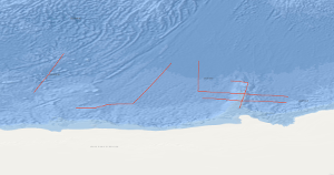
Processed seismic data of Cruise ANTVIII/6 1990
The POLARSTERN cruise ANTVIII/6 from 14. March to 30. April 1990 incorporated an integrated geophysical reconnaissance survey consisting of multichannel seismic measurements in parallel with gravimetric and magnetic measurements. The survey covered the plateaus Maud Rise, Astrid Ridge and Gunnerus Ridge off Queen Maud Land and the oceanic crust in their vicinity. Severe ice and weather conditions allowed seismic work only on the Gunnerus Ridge and on the oceanic crust. Together with previous BGR lines on the Astrid Ridge and the Maud Rise the new data improve considerably the understanding of the area. The main results are: 1. The oldest identified sea-floor spreading anomaly was M11 before the cruise, now it is M24. Thus spreading has begun not only 135 mill. years B.P., but at least 160 mill. years B.P. 2. The Gunnerus Ridge is strongly asymmetric. The mainly weak magnetic anomalies indicate that in contrast to the Astrid Ridge volcanism was not important during its development. 3. The magnetic anomalies are much stronger on the Astrid Ridge and west of it than east of the Astrid Ridge and on the Gunnerus Ridge. 4. The roughness of the basement surface of the oceanic crust varies in a wide range.
|
|
Citation proposal
. Processed seismic data of Cruise ANTVIII/6 1990. https://gdk.gdi-de.org/geonetwork/srv/api/records/dd441209-9466-4826-8766-7480e5f19025 |
INSPIRE
Identification
- File identifier
- dd441209-9466-4826-8766-7480e5f19025 XML
- Hierarchy level
- Dataset
Online resource
Resource identifier
- code
- e85e4a67-3d77-6b22-0219-20e494bc9182
- Metadata language
- English
- Spatial representation type
- Vector
Encoding
- Format
- Shapefile
- Version
- n/a
Projection
Classification of data and services
- Topic category
-
- Geoscientific information
Classification of data and services
Coupled resource
Coupled resource
Classification of data and services
Coupled resource
Coupled resource
Keywords
- GEMET - INSPIRE themes, version 1.0 ( Theme )
-
- Geologie
- geology
- GEMET - Concepts, version 2.4 ( Theme )
-
- geophysics
- Geophysik
- raw material
- Rohstoff
Other keywords
- Keywords ( Theme )
-
- Marine geology
- Meeresgeologie
- Seismics
- Seismik
- Two-dimensional seismic reflection
- zweidimensionale Reflektionsseismik
- Keywords ( Place )
-
- Atlantic-Indian Antarctic Basin
- Antarktisches Becken
- Astrid Ridge
- Gunnerus Ridge
- Maud Rise
- Astrid-Rücken
- Gunnerus-Rücken
- Maud-Kuppe
Geographic coverage
N
S
E
W
))
Temporal reference
Temporal extent
Temporal extent
- Date ( Creation )
- 1990-04-30
Quality and validity
- Lineage
- During the period from the 14th March 1990 to the 30th April 1990 BGR acquired seismic lines off Queen Maud Land in the Atlantic-Indian Antarctic Basin. The lines ANT8-1 to ANT8-10 consist of raw data.
Conformity
Conformity
Conformity
Conformity
Conformity
Conformity
- Explanation
- siehe dazu die angegebene Durchführungsbestimmung
Restrictions on access and use
- Access constraints
- Allgemeine Geschäftsbedingungen, siehe http://www.bgr.bund.de/AGB - General terms and conditions, see http://www.bgr.bund.de/AGB_en. Die bereitgestellten Informationen sind bei Weiterverwendung wie folgt zu zitieren: Datenquelle: ANTVIII/6 1990, (c) BGR, Hannover, 2019
Restrictions on access and use
Responsible organization (s)
Contact for the resource
- Organisation name
- Federal Institute for Geosciences and Natural Resources
- Marine_Seismik@bgr.de
Responsible organization (s)
Contact for the resource
- Organisation name
- Federal Institute for Geosciences and Natural Resources
- Marine_Seismik@bgr.de
Metadata information
Contact for the metadata
- Organisation name
- Bundesanstalt für Geowissenschaften und Rohstoffe (BGR)
- Date stamp
- 2023-11-14
- Metadata language
- English
- Character set
- UTF8
SDS
Conformance class 1: invocable
Access Point URL
Endpoint URL
Technical specification
Conformance class 2: interoperable
Coordinate reference system
Quality of Service
Access constraints
Limitation
Use constraints
Limitation
Responsible custodian
Contact for the resource
Conformance class 3: harmonized
Overviews
Provided by

Views
dd441209-9466-4826-8766-7480e5f19025
Access to the portal
Read here the full details and access to the data.
Associated resources
Not available