 www.geodatenkatalog.de (S1L)
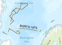
Processed seismic data of Cruise BGR 1975
Reconnaissance surveys were carried out in 1975 within the framework of the BGR program "Geoscientific studies in the North Atlantic". The data format is Society of Exploration Geophysicists SEG Y. The areas covered were the continental margin of Spitsbergen, the Barents Sea and the Norwegion continental margin. On the vessel LONGVA (30th August, 1975 - 29th September, 1975) multichannel seismic measurements were carried out on 37 lines with a total length of 2,815 km.
|
|
Citation proposal
. Processed seismic data of Cruise BGR 1975. https://gdk.gdi-de.org/geonetwork/srv/api/records/dd4fd1fa-4371-4afa-939c-f02a4a64d64a |
INSPIRE
Identification
- File identifier
- dd4fd1fa-4371-4afa-939c-f02a4a64d64a XML
- Hierarchy level
- Dataset
Online resource
Resource identifier
- code
- 544495f0-fbf3-4e01-83ca-e52cc236f870
- Metadata language
- English
- Spatial representation type
- Vector
Encoding
- Format
- Shapefile
- Version
- n/a
Projection
Classification of data and services
- Topic category
-
- Geoscientific information
Classification of data and services
Coupled resource
Coupled resource
Classification of data and services
Coupled resource
Coupled resource
Keywords
- GEMET - INSPIRE themes, version 1.0 ( Theme )
-
- geology
- Geologie
- GEMET - Concepts, version 2.4 ( Theme )
-
- geophysics
- Geophysik
- raw material
- Rohstoff
- marine geology
- Meeresgeologie
Other keywords
- Keywords ( Theme )
-
- seismics
- Seismik
- two-dimensional seismic reflection
- zweidimensionale Reflektionsseismik
- MSSP
- Keywords ( Place )
-
- North Atlantic
- Nordatlantik
- Barentssea
- Barentssee
Geographic coverage
N
S
E
W
))
Temporal reference
Temporal extent
Temporal extent
- Date ( Creation )
- 1975-09-29
Quality and validity
- Lineage
- During the period from 29th of August to 29th of September 1975 BGR aquired seismic lines in the North Atlantic. The lines BGR75-01, BGR75-02A, BGR75-05, BGR75-06, BGR75-07, BGR75-08, BGR75-09, BGR75-10, BGR75-11A, BGR75-12, BGR75-13, BGR75-14, BGR75-15, BGR75-16, BGR75-17, BGR75-18, BGR75-19, BGR75-20, BGR75-21, BGR75-22A, BGR75-22B, BGR75-23, BGR75-24, BGR75-26, BGR75-26A are processed (stack) data and BGR75-01A, BGR75-02, BGR75-03, BGR75-04, BGR75-07A, BGR75-08A, BGR75-11, BGR75-15A, BGR75-22, BGR75-25 are raw data.
Conformity
Conformity
Conformity
Conformity
Conformity
Conformity
- Explanation
- siehe dazu die angegebene Durchführungsbestimmung
Restrictions on access and use
- Access constraints
- Allgemeine Geschäftsbedingungen, siehe https://www.bgr.bund.de/AGB - General terms and conditions, see https://www.bgr.bund.de/AGB_en. Die bereitgestellten Informationen sind bei Weiterverwendung wie folgt zu zitieren: Datenquelle: BGR75, (c) BGR, Hannover, 1975
Restrictions on access and use
Responsible organization (s)
Contact for the resource
- Organisation name
- Federal Institute for Geosciences and Natural Resources
- Marine_Seismik@bgr.de
Responsible organization (s)
Contact for the resource
- Organisation name
- Federal Institute for Geosciences and Natural Resources
- Marine_Seismik@bgr.de
Metadata information
Contact for the metadata
- Organisation name
- Bundesanstalt für Geowissenschaften und Rohstoffe (BGR)
- Date stamp
- 2025-04-07
- Metadata language
- English
- Character set
- UTF8
SDS
Conformance class 1: invocable
Access Point URL
Endpoint URL
Technical specification
Conformance class 2: interoperable
Coordinate reference system
Quality of Service
Access constraints
Limitation
Use constraints
Limitation
Responsible custodian
Contact for the resource
Conformance class 3: harmonized
Overviews
Provided by

Views
dd4fd1fa-4371-4afa-939c-f02a4a64d64a
Access to the portal
Read here the full details and access to the data.
Associated resources
Not available