 My GeoNetwork catalogue
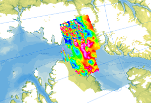
Helicopter-borne Magnetics NARES I + II (Kane Basin)
In May/June 2001, as part of the expedition NARES I, an aeromagnetic survey was carried out in the area of the eastern Kane Basin in cooperation with the Canadian GSC, in addition to the survey over the Robeson Channel and parallel to marine geophysical investigations with the Canadian icebreaker Louis S. St. Laurent. Another survey, NARES II, was conducted from Alexandra Fiord in 2003 and covered coastal areas of Ellesmere Island and the western Kane Basin. The aim of the research was to detect and localize the Wegener Fault, a transform fault between Ellesmere Island and NW Greenland, which is closely linked to the opening of the North Atlantic and the Arctic Ocean. The helicopter-borne magnetic surveys NARES I + II (Kane Basin) were carried out with a flight line spacing of 2 km, and control profiles were flown every 10 km. During the two expeditions, 11806 km of line data were collected (3573 km in 2001, and 8333 km in 2003), covering an area of approximately 20000 km². The aeromagnetic data were recorded by a magnetometer, which was towed approx. 25 m beneath the helicopter.
Simple
- Alternate title
-
AeromagNARES
- Date (Publication)
- 2023-02-22
- Citation identifier
- e99937e5-a02d-63ad-7afa-5afe19039d3e
- Status
- Completed
-
GEMET - INSPIRE themes, version 1.0
-
-
Geologie
-
Geology
-
-
GEMET - Concepts, version 2.4
-
-
Geophysik
-
- Theme
-
-
Aerogeophysik
-
Aeromagnetik
-
Anomalien des erdmagnetischen Feldes
-
Airborne geophysics
-
helicopter-borne /fixed-wing magnetics
-
anomalies of the Earth’s magnetic field
-
- Place
-
-
Arktis
-
Arctic
-
Nordpolargebiet
-
North Polar
-
Nares Strait
-
- Access constraints
- Other restrictions
- Other constraints
- Es gelten keine Zugriffsbeschränkungen
- Use constraints
- Other restrictions
- Other constraints
-
Allgemeine Geschäftsbedingungen, siehe https://www.bgr.bund.de/AGB - General terms and conditions, see https://www.bgr.bund.de/AGB_en . Die bereitgestellten Informationen sind bei Weiterverwendung wie folgt zu zitieren: Datenquelle: AeromagNARES, (c) BGR, Hannover, 2023
- Language
- English
- Character set
- UTF8
- Topic category
-
- Geoscientific information
))
- Unique resource identifier
- EPSG:3995
- Distribution format
-
-
GeoTIFF
(
n/a
)
-
shp
(
n/a
)
-
WMS
(
OGC:WMS1.3.0
)
-
GeoTIFF
(
n/a
)
- OnLine resource
-
AeromagNARES (GeoTIFF)
AeromagNARES im Format geoTiff
- OnLine resource
- Karte im BGR-Geoviewer
- OnLine resource
-
Flightlines (Shape)
Flightlines im Format Shape
- OnLine resource
- Polarforschung - CASE
- Hierarchy level
- Dataset
- Statement
-
The aeromagnetic data were jointly collected by GSC Canada and BGR between Ellesmere Island and NW Greenland as part of the NARES I and II expeditions.
- File identifier
- ddbc45ac-7d84-4ff5-80b1-adaae860ad18 XML
- Metadata language
- English
- Character set
- UTF8
- Parent identifier
-
Helicopter-borne Magnetics in the Arctic region
e85d6dcc-91b8-48bc-a80d-7ca0f9546cda
- Hierarchy level
- Dataset
- Hierarchy level name
-
Geophysik
- Date stamp
- 2026-01-13
- Metadata standard name
-
INSPIRE Metadata Implementing Rules: Technical Guidelines based on EN ISO 19115 and EN ISO 19119
- Metadata standard version
-
n/a
Overviews
Spatial extent
Provided by
